
LB BARKING & DAGENHAM
DIGITAL INFRASTRUCTURE DELIVERY PLAN

1. INTRODUCTION
1.1 Infrastructure Covered in this Plan
1.1.1 The London Borough of Barking and Dagenham (the ‘Council’) has commissioned Troy Planning + Design to prepare an Infrastructure Delivery Plan (IDP) to help support the emerging Local Plan.
1.1.2 The term ‘infrastructure’ covers a wide range of services and facilities provided by public and private organisations; it is defined in section 216(a) of the Planning Act 2008 (as amended). The Barking and Dagenham IDP covers a mix of physical, social and green infrastructure, including:
Physical Infrastructure
- Flood Defences
- Water Supply and Wastewater
- Transport
- Utilities
- Telecommunications (and Internet)
- District Energy Network
- Waste
- Wholesale Markets
Social Infrastructure
- Education
- Health and Social Wellbeing
- Emergency Services
- Community Facilities (including Recreation and Sports Facilities)
Green Infrastructure
- Open Spaces
- Allotments
- Burial Grounds
1.2 Purpose of the Report
1.2.1 This IDP seeks to assess the current provision of infrastructure (by type) in Barking and Dagenham, whilst also providing an overview of future infrastructure requirements and needs for the Borough that reflects emerging Local Plan policies. Discussions with a variety of service providers have taken place, both within Be First, and with the Council and external providers, to generate a comprehensive insight into current infrastructure position, and future proposals. Consideration has also been given to adopted strategies, evidence bases and plans. This IDP consolidates all information that has been made available by strategy review and agencies’ feedback to form one full document.
1.2.2 Any future update to this report that relates to the Local Plan’s progress will require infrastructure providers to think strategically and specifically about potential borough-wide, planning policy-related challenges (brought about by significant, planned long-term growth) and future provision. This should encourage information sharing and coordinated infrastructure planning between different service providers, the Council and Be First.
1.3 Status of the report
1.3.1 The IDP is a supporting document to the emerging Local Plan, which will provide strategic policies for the Borough; it forms part of the Plan’s evidence base. A series of site-specific, non-statutory masterplans will
provide more detailed, non-strategic policies for areas within the Borough and will further support the emerging Local Plan. The IDP will cover
the full Local Plan period up to 2037. The IDP should be regarded as a living document, which will be subject to periodic monitoring and review, particularly as more information on strategic development site allocations emerge.
1.3.2 This document includes details of the current infrastructure baseline, acknowledging future proposals and providers’ intentions where they exist or are known. Where possible, this document also calculates future infrastructure requirements over the Plan period (up to 2037).The
development trajectory that the IDP is based on has an earlier start date as it makes an allowance for development that has already been permitted.
1.4 Engagement with Service Providers and Developers
1.4.1 Due to the uncertainties surrounding future infrastructure requirements, this IDP is intended to be regularly updated in partnership with relevant agencies in order to reflect the fluid and constantly evolving nature of infrastructure planning.
1.4.2 Organisations contacted to date, to help inform this IDP, include:
- Barking Havering and Redbridge (BHR) NHS CCG
- Be First
- BT Openreach
- East London Waste Authority
- Environment Agency
- Essex and Suffolk Water
- London Borough of Barking and Dagenham (LBBD) Council
- London Borough of Havering
- London Borough of Newham
- London Borough of Redbridge
- London Fire Brigade
- Marine Management Organisation (MMO)
- Metropolitan Police
- National Grid
- Port of London Authority
- Sports England
- Transport for London (TfL)
- UK Power Networks (UKPN)
- Virgin Media
1.4.3 In order to gain a fuller understanding of the current and future level of infrastructure provision, relevant Council staff and external service
providers were invited to submit detailed information in response to the following questions:
- What level of infrastructure is currently provided?
- Are there any specific problems which influence the level of
infrastructure provided? - What existing plans and proposals for new infrastructure are in place?
- What additional infrastructure will be needed as a result of the growth proposed in the Plan period (up to 2037)?
- What are the costs of the planned infrastructure, and what funding mechanisms will be used (e.g.s106 planning obligation/ community infrastructure levy (CIL))?
- What are the likely costs of new infrastructure?
1.4.4 A series of additional questions tailored to each specific infrastructure type
was also included at this stage.
1.4.5 In March 2020, workshops were held with internal service providers. These workshops were structured around the three key pillars of: physical, social and environmental infrastructure. The aim of this exercise was to assess the accuracy of our existing baseline, in addition to gathering new information on the future plans for each infrastructure type over the next 18 years. Information gathered during the workshops and subsequent follow-up was incorporated into the IDP.
1.4.6 Developers, site promoters and landowners were also contacted as part of the IDP engagement process. Information was sought from developers whose strategic sites identified for 500 or more homes in the emerging Local Plan. Information including: the site context, constraints, indicative masterplans/site layouts and planned provision of on-site and off-
site infrastructure was requested from site developers. In each case, information received was incorporated into Chapter 9 of this report.
1.5 Approach
1.5.1 In recognition of the complexities surrounding borough-wide infrastructure requirements for Barking and Dagenham, a number of important principles have been used as reference points to guide the formation of this IDP. They include the following:
- Unless stated otherwise, all assumptions in the IDP are based on the growth earmarked within the Council’s July 2020 housing trajectory. It is noted that the Council has applied the following criteria when allocating sites:
a) total site area or remaining developable area equates to >0.25ha or;
b) the site delivers 1,000 units or more, or;
c) can deliver a critical/essential piece of infrastructure over the Plan period, or;
d) is allocated as a masterplan site (Thames Road, Chadwell Heath, Castle Green, Barking Town Centre) - The IDP does not seek to make up for historic deficits in infrastructure. However, there are instances where supporting growth might most effectively be achieved through the upgrading of existing facilities. This could include, for example, extending existing schools or enhancing current public transport services.
- Not all housing and employment growth planned for individual sites will attract specific additional infrastructure requirements that can be addressed through the development of that site alone. In most cases, the infrastructure needs that have been identified reflect the cumulative impact of growth in a wider area e.g. based on growth through the strategic sites, smaller allocations and windfall sites that are used for planning purposes by the Council.
- London Boroughs are increasingly looking to co-locate their services in order to make the most of their existing assets. Driven in part by the rising costs associated with the lack of availability – and high cost – of land and floorspace, co-location is seen by some as a method of capturing multiple benefits for local communities. Co-location can take many forms. For example, schools are increasingly looking to raise revenue by hiring out sports pitches and other facilities outside of school hours to house local community group meetings. The co-location of new residential development and schools – with considerable potential funding benefits – is an emerging proposition. The shift of GP services into consolidated primary healthcare hubs may yield a more equitable share of resources and facilities for a range of health providers, as well as offering a more diverse range of facility uses e.g. healthcare services, community centres and retail. Ultimately, decisions relating to the co-location of services are tied to changes made to financial arrangements and management structures. There may be some cases where these intricacies have been difficult to capture within this IDP.
- Whilst it is important to be aware of the changeable components to service delivery, it is extremely difficult for an IDP to be definitive about what future service requirements may be. Therefore, it is important to note that variances in service needs will have significant impacts on future infrastructure requirements and associated costs.
1.6 Reflective Summary
1.6.1 Information within the IDP has been gathered through an in-depth analysis of all relvant strategies and plans, as well as engagement with statutory and non-statutory consultees. This includes engament with Duty to Cooperate partners and internal and external service providers. In some cases, it was not possible to obtain the most up-to-date informattion regarding particular infrastructure types. Limited information was available for the following infrastructure types: Wastewater, Water Supply, Gas, Adult Learning, Further Education, Community Centres, Children’s Play and Youth Facilties, Allotments and Burial Grounds.
1.6.2 It is acknowledged that supplementary plans and strategies are to be published in due course. It should therefore be noted that this IDP will be reviewed periodically to ensure that it reflects the most up-to date information available.
2. POLICY CONTEXT
2.1 National Planning Policy
2.1.1 The context for the IDP is provided by the National Planning Policy Framework (NPPF [1], revised 2019). As stated by the NPPF, the planning system’s key purpose is to contribute to achieving sustainable development. For example, the NPPF [para.8] states that its objectives include: ‘identifying and coordinating the provision of infrastructure’ and ‘supporting strong, vibrant and healthy communities… with accessible services and open spaces that reflect current and future needs and support communities’ health, social and cultural well-being’.
2.1.2 The NPPF [para.20] further states that:
2.1.3 ‘Strategic policies should set out an overall strategy for the pattern, scale
and quality of development, and make sufficient provision for:
- housing (including affordable housing), employment, retail, leisure and other commercial development;
- infrastructure for transport, telecommunications, security, waste management, water supply, wastewater, flood risk and coastal change management, and the provision of minerals and energy (including heat);
- community facilities (such as health, education and cultural infrastructure); and
- conservation and enhancement of the natural, built and historic environment, including landscapes and green infrastructure, and planning measures to address climate change mitigation and adaptation’.
2.1.4 Paragraph 72(d) of the NPPF states that local authorities should ‘make a realistic assessment of likely rates of delivery, given the lead-in times for large scale sites, and identify opportunities for supporting rapid
implementation (such as through joint ventures or locally led development corporations)’.
2.1.5 Furthermore, (footnote 35) highlights that ‘the delivery of large-scale developments may need to extend beyond an individual plan period, and the associated infrastructure requirements may not be capable of being identified fully at the outset. Anticipated rates of delivery and infrastructure requirements should, therefore, be kept under review and reflected
as policies are updated’. The above policies have proved particularly informative in developing this IDP.
2.2 National Infrastructure Assessment
2.2.1 In July 2018 the first ‘National Infrastructure Assessment’ was published. This sets out a long-term strategy for the UK’s economic infrastructure from 2020 to 2050. It includes a number of recommendations to Government that could be implemented within the time period covered by the emerging Local Plan. These include:
- Nation-wide full fibre broadband by 2033.
- Half of the UK’s power to be provided by renewables by 2030.
- Three quarters of plastic packaging to be recycled by 2030.
- Preparing for 100 per cent electric vehicle sales by 2030.
2.2.2 Other recommendations include:
- £43 billion of stable long-term transport funding for regional cities.
- Ensuring resilience to extreme drought.
- A national standard of flood resilience for all communities by 2050.
2.2.3 The implication is that the Government, along with service providers and regulating bodies, all need to begin delivering the necessary programmes to put the above in place. For London specifically, it is recognised that future growth of the transport networks will not be possible without substantial increases in capacity.
2.3 Development Plan
2.3.1 The statutory Development Plan for the Borough consists of:
- The London Plan (adopted 2016) and the ‘Intend to Publish’ London Plan, published in December 2019.
- The Local Plan (2010) is comprised of the following Development Plan Documents (DPDs):
– Core Strategy (2010)
– Borough Wide Development Policies (2011)
– Site Specific Allocations (2010)
– Barking Town Centre Area Action Plan (2011)
– Proposals Map (2012) - Joint Waste Delivery Plan (2012) – made up of four East London Waste Authority boroughs (Barking and Dagenham, Havering, Newham and Redbridge) – currently under review
2.3.2 Be First for the Council is currently preparing a Local Plan which will set out future planning policies in the Borough between 2019 and 2037. The emerging Local Plan will be structured by seven sub-areas. The Plan will provide employment and housing targets to be delivered in the Plan period, as well as setting out requirements for new transport links and community facilities to meet the needs of new and existing residents. The emerging Local Plan went through its Regulation 18 consultation process in late 2019; therefore it is not yet part of the development plan but is a material consideration in the determination of planning applications. Increasing weight will be attached to it, the further it progresses through the plan making process (e.g. reflecting how it is amended to respond to public consultation outcomes, for example).
2.4 London Plan
2.4.1 Barking and Dagenham’s planning policies must be in ‘general conformity’ with the London Plan. The current London Plan outlines the Mayor
of London’s spatial development strategy, and sets out an integrated transport, economic, environmental and social framework for Greater London. As emphasised by the London Plan, all future infrastructure should contribute to improving the overall sustainability of activities within London.
2.4.2 Despite the emerging Intend to Publish London Plan not yet being formally adopted, it is important to afford considerable weight to the emerging London Plan’s policies; which have been subject of Panel examination (the Inspectors’ Report was published on 8th October 2019 [2]). Of relevance to this IDP and the proposed growth within the Borough, the Intend to Publish London Plan policies (2019) state that:
2.4.3 Chapter 8 of the Intend to Publish London Plan [3] states that “Green infrastructure should be actively planned, designed and managed to bring about benefits such as promoting mental and physical health and wellbeing, and mitigating climate change effects.”
2.4.4 The Intend to Publish London Plan also emphasises the importance of planning for social infrastructure, which includes: health provision,
education, community, play, youth, early years, recreation, sports, faith, criminal justice and emergency facilities.
2.4.5 Physical infrastructure priorities set out in the Intend to Publish London Plan include strategic transport priorities for London, including the Barking Riverside to Abbey Wood London Overground crossing and the Barking Riverside Overground extension (paras. 2.1.40 and 2.1.43). In addition, Policy E5 Strategic Industrial Locations (SIL) highlights that Dagenham Dock, Rippleside and River Road Employment Area are to be given strategic protection.
2.4.6 Policy SD1 has allocated 44,000 new homes and 29,000 new jobs for the London Riverside Opportunity Area (this Opportunity Area includes development earmarked on sites south of the A13).
2.4.7 Policy D2 stipulates that “the density of development proposals should consider, and be linked to, the provision of future planned levels of infrastructure rather than existing levels; and; be proportionate to the site’s connectivity and accessibility by walking, cycling and public transport to jobs and services (including both PTAL and access to local services)”.
2.4.8 Policy SD2 states that borough should “identify Strategic Areas for Regeneration in Local Plans and develop policies that are based on a thorough understanding of the demographics of communities and their needs”. The Plan notes that “there should be a focus on these areas […] to ensure these areas benefit from investment in strategic infrastructure, social infrastructure and regeneration initiatives”.
2.4.9 Policy D1 highlights the importance of planning for growth, by stating that “in preparing Development Plans, boroughs should […] assess the capacity of existing and planned physical, environmental and social infrastructure to support the required level of growth, and, where necessary, improvements to infrastructure capacity should be planned in infrastructure delivery plans or programmes to support growth”.
2.4.10 Policy D3 clarifies that “all development must […] follow a design-led approach which […] responds to a site’s context and capacity for growth, and existing and planned supporting infrastructure capacity”.
2.4.11 With regard to local housing capacity figures, paragraph 4.1.12 asserts that “[in cases where a target is need beyond the 10 year period up to 2028/29], boroughs should draw on the 2017 SHLAA findings (which cover the period to 2041) and any local evidence on identified capacity, in consultation with the GLA, and should take account any additional capacity that could be delivered as a result of any committed transport infrastructure improvements, and roll forward the housing capacity assumptions applied in the London Plan for small sites”.
2.4.12 Table 4.1 outlines that the ten-year housing target (2019/20-2028/29) for Barking and Dagenham is 19,440 units.
2.4.13 Policy S1 states that “[when preparing Development Plans], boroughs should ensure the social infrastructure needs of London’s diverse communities are met”. Policy S1 later adds that “in areas of major new devleopment and regeneration, social infrastructure needs should be addressed via area-based planning such as Opportunity Area Planning Frameworks, Area Action Plans, Development Infrastructure Funding Studies, Neighbourhood Plans of master plans”.
2.4.14 With regard to London’s existing industrial land, Policy E4a) iterates that
“a sufficient supply of land and premises in different parts of London to meet current and future demands for industrial and related functions should be provided and maintained, taking into account strategic and local employment reviews, industrial land audits and the potential for intensification, co-location and substitution”.
2.4.15 Policy E4c) stipulates that “the retention, enahancement and provision of additional industrial capacity across the three categors of industrial land (Strategic Industrial Locations, Locally Significant Industrial Sites and Non-Designated Industrial Sites) should be planned, monitoried and managed, having regard to the industrial property market area and borough-level categorisations. This should ensure that in overall terms across London there is no net loss of industrial floorspace capacity (and operational yard space capacity) within designated SIL and LSIS”.
2.4.16 Barking and Dagenham is classified as ‘limited release’, whereby industrial land vacancy rates are currently well above the London average and boroughs are encouraged to intensify industrial floorspace capacity, investigate the reasons for high levels of vacancy and take positive steps to bring vacant sites back into use where there is demand, whilst also supporting the re-use of surplus industrial land and floorspace for other uses through a proactive plan-led approach”.
2.4.17 Policy E4c) adds that “any release of industrial land in order to manage issues of long-term vacancy and to acheive wider planning objectives, including the delivery of strategic infrastructure, should be facilitated through the processes of industrial intensification, co-location and substitution”.
2.4.18 Policy E10 encourages the strengthening of London’s visitor economy by “enhancing and extending its attractions, inclusive access, legibility, visitor experience and management and supporting infrastructure”.
2.4.19 With regard to London’s cultural offering, Policy HC5 supports the continued growth and evolution of London’s diverse cultural facilities and creative industries, through “protecting existing venues, facilities and uses where appropriate and supporting the development of new cultural venues in town centres and places with good public transport connectivity”.
2.4.20 Linked to the above, Policy HC6 states that Development Plans should “promote the night-time economy”.
2.4.21 Policy G1 states that “London’s network of green and open spaces, and green features in the built environment should be protected and enhanced”.
2.4.22 Policy SI3 states that “Boroughs should engage at an early stage with relevant energy companies and bodies to establish the future energy and infrastructure requirements from large-scale development proposals”.
2.4.23 Policy SI5 states that “Development Plans should promote improvements to water supply infrastructure to contribute to security of supply”.
2.5 Infrastructure Funding Statements
2.5.1 On 1 September 2019, amendments to the CIL Regulations [4] came into force. The Government has revoked Regulation 123, which has in effect removed the “pooling restriction”, which until 1 September had prevented local planning authorities from using more than five section 106 obligations to fund a single infrastructure project [5]. As of 31 December 2020, local authorities are required to publish annual infrastructure funding statements, instead of Regulation 123 infrastructure lists. Within these statements, local authorities will be obliged to set out infrastructure projects that the authority intends will be, or may be, wholly or partly funded by planning obligations (including S106) or by the levy (CIL). This amendment lifts restrictions currently in place, such that local planning authorities will no longer be tied to spending CIL receipts specified on the currently required Regulation 123 lists. The Council and Be First are currently preparing an Infrastructure Funding Statement, which is due to be published in late 2020.
3. BARKING & DAGENHAM CONTEXT
3.1 Overview
3.1.1 The London Borough of Barking and Dagenham is an Outer London Borough located in East London. It covers an area of 3,611ha [6] and borders the London Boroughs of Havering, Bexley, Greenwich, Newham and Redbridge.
3.1.2 Mid-2018 population statistics estimate that Barking and Dagenham has a total population of 211,998, of which 27% are aged 0-15, 63% are aged 16-64 and 9% are 65 or over [7]. As of 2018, 69% of the population are in employment, compared to the national average of 74.5%. Educational
attainment within the Borough is varied and somewhat polarised, as 33% of the population have a qualification equivalent to an NVQ4 or higher, whilst 8.2% have no qualifications [8].
3.1.3 The population of Barking and Dagenham is highly diverse, as 37.8% of the resident population were born abroad. The largest migrant population by birth are Nigerian, who make up 4.7% of the overall population within the Borough [9].
3.1.4 The median house price in the Borough was £234,500 in 2015, which was
£156,450 lower than the median house price for Greater London. Census data (2011) [10] reveals that 48% of homes in the Borough are owner- occupied, 28% are Council-owned, 18% are privately rented, 5% are listed under registered social landlords and 1% represent other tenures.
3.1.5 Car ownership is lower than the national average (0.8 cars per household, in comparison to 1.1). Despite this, only 8.8% of the adult population cycle at least once per month, relative to the national average of 14.7% of adults.
3.2 Economy
3.2.1 There are currently 65,000 jobs within Barking and Dagenham, of which 11% of employee jobs are within the wholesale and retail trade industry.
3.2.2 Within the Borough, there is a concentration of micro-enterprises and local units (92.8% and 88.4% respectively), in comparison to national averages (90.6% and 87.1% respectively). There is a notable lack of larger enterprises (250+ employees) within the Borough, as they make up just 0.2% of the business offer, in comparison to the national average (0.4%).
3.2.3 Recent changes to Barking and Dagenham’s economic landscape include the re-use of the redundant energy site at Barking Riverside (earmarked for approx. 9,600 homes) and the closure of Barking Reach power station in 2014. Together, these ongoing and/or proposed changes drastically alter the infrastructure requirements within the borough. The emerging Local Plan includes policies which seek to intensify existing industrial sites to enable land to be freed up for alternative uses such as housing. This is the case for strategic sites such as Barking Riverside, the Stamping Plant and the Chadwell Heath Industrial Estate.
3.2.4 In addition, the projected change in demand for warehouse floorspace and land is estimated to increase by 245,900sqm (equating to 37.8ha) over the 2016-2041 period.
3.2.5 The following chapters make reference to the Borough’s seven sub-areas. It is important to note that these sub-areas have been set out and defined in the emerging Local Plan as areas which comprise “distinctive characters, opportunities, constraints and broad principles for development.” These seven sub-areas are:
- Barking Town Centre and River Roding
- Thames Road, Barking Riverside and Castle Green
- Dagenham Dock, Beam Park and the Stamping Plant
- Dagenham East and Dagenham Village
- Becontree
- Becontree Heath and Rush Green
- Chadwell Heath and Rush Green
3.3 Transport
3.3.1 Although the Borough is serviced by a variety of transport modes, there are recurring issues regarding a lack of connectivity and fragmentation
– both locally and further afield. At present, there are 248 miles of road in Barking and Dagenham, including the A12 and A13 which connect the Borough with Stratford, Poplar and Essex [11].
3.3.2 With regard to rail infrastructure, Barking and Dagenham is served by the east-west radial network, which is comprised of: National Rail services connecting London and Southend; London Underground services via the District and Hammersmith and City lines; London Overground connecting Barking to Gospel Oak; and TfL, which offers suburban services between London and Shenfield. In addition, the Borough is served by 26 bus routes offering local connections, of which 23 run daily services across the local authority area. A key challenge concerning transport connectivity within Barking and Dagenham is the lack of north/south and orbital links.
3.3.3 The walking and cycling network in the Borough is extensive, including: Cycle Superhighway 3 (providing links between Barking and Tower Hill); local ‘Quietways’; 7km of continuous Greenway cycling routes through borough parks and a 16km rights of way network among other more localized routes. Walking and cycling routes are however perceived as fragmented and there are opportunities to link the existing infrastructure.
3.3.4 The Council’s third Local Implementation Plan (LIP3) (2019) outlines their strategy for delivering improvements to Barking and Dagenham’s
transport system. It aims to secure funding and deliver extensive transport improvements/investments and interventions to serve anticipated growth.
4. SCALE AND LOCATION OF GROWTH
4.1 Proposed Growth in Barking and Dagenham over the Plan period (2019-2037)
4.1.1 The Intend to Publish London Plan has set a ten-year housing target (2019/2020-2028/2029) of 19,440 homes in Barking and Dagenham. The housing supply in the emerging Local Plan thus needs to conform with GLA targets. It is also worth noting that Barking and Dagenham forms part of the London Riverside Opportunity Area as earmarked in the Intend to Publish London Plan, which has indicative target of 44,000 new homes and 29,000 new jobs.
4.1.2 The emerging Local Plan’s vision states that “the borough will play an important role in shaping east London’s future by moving away from industrial decline and driving London’s economic growth, whilst leaving no-one behind by creating high quality places for people to live, work and visit.” Central to this vision, the Plan has identified opportunities for new and existing infrastructure, which includes the opportunity to “delivering
new and improved infrastructure to unlock land for new redevelopment and stimulate and facilitate investment, particularly a new rail station at Barking Riverside with the extension of the London Overground, the proposed undergrounding of a section of the A13 road, and the arrival of Crossrail at Chadwell Heath”.
4.1.3 The emerging Local Plan figure has allocated for approximately 40,000 homes over the Plan period and an additional 19,000 (approx.) beyond the Plan period. In addition, approximately 40 hectares of land has been earmarked for employment uses, together with a vision to deliver 20,000 new jobs over the Plan period.
| SUB-AREA | New homes delivered in Plan period (2019-2037) | New homes delivered beyond Plan period (2037+) |
| Barking Town Centre and the River Roding | 15,198 | 66 |
| Thames Road, Barking Riverside and Castle Green | 13,170 | 11,250 |
| Dagenham Dock, Beam Park and the Stamping Plant | 6,316 | 0 |
| Becontree | 1,386 | 0 |
| Chadwell Heath and Marks Gate | 3,868 | 685 |
| Becontree and Rush Green | 561 | 0 |
| Dagenham East and Dagenham Village | 1,217 | 0 |
Table 01: A breakdown of Barking and Dagenham’s housing trajectory over and beyond the Plan period (based on July 2020 housing trajectory)
4.2 Proposed housing phasing throughout Plan period (2019-2037)
4.2.1 Future growth across the borough will primarily consist of new allocations on former industrial sites, including residential intensification in sites situated in Barking Town Centre. It is intended that these allocated sites will undergo phased deliveries spanning the Plan period, divided into years 0-5, 6-10 and 11-18 of the Plan period. Indicative phasing of housing delivery for each of the Borough’s sub-areas is highlighted in Table 2 below.
4.2.2 As shown, in sub-areas which include larger site allocations (such as Dagenham Dock, Beam Park and the Stamping Plant and Thames Road and Castle Green), phased delivery will occur in a staged manner throughout the Plan period, whereas in areas earmarked for less growth (Becontree and Becontree Heath and Rush Green) phased delivery will commence in the early-mid stages of the Plan period.
| SUB-AREA | Years 1-5 of Plan period (2019/20- 2023/24) | Years 6-10 of Plan period (2024/25- 2029/30) | Years 11-18 of Plan period (2030/2031- 2036/37) |
| Barking Town Centre and the River Roding | 4,626 | 7,735 | 2,837 |
| Thames Road, Barking Riverside and Castle Green | 3,284 | 4,772 | 5,114 |
| Dagenham Dock, Beam Park an the Stamping Plant | 1,165 | 2,985 | 2,166 |
| Becontree | 223 | 1,013 | 150 |
| Chadwell Heath and Marks Gate | 653 | 1,215 | 2,000 |
| Becontree and Rush Green | 561 | 0 | 0 |
| Dagenham East and Dagenham Village | 135 | 451 | 631 |
| TOTAL: | 10,647 | 18,171 | 12,898 |
Table 02: Phasing delivery for Barking and Dagenham’s housing trajectory over the Plan period (based on July 2020 housing trajectory)
4.3 Employment Growth
4.3.1 The emerging Local Plan (2019) supports the delivery of approximately 20,000 new jobs between 2019 and 2037. The Council’s economic vision states that the Borough will evolve as one of London’s most distinctive and future-facing economies, where significant investment will deliver new jobs and improve the productivity of the economy [12 – The Future of Our Employment Land LBBD, Hawkins/Brown and We Made That (2019)]. The emerging Local Plan highlights that new major office development will be directed to Barking’s town centre, with secondary provision in district centres.
4.3.2 With reference to proposed site allocations in the emerging Local Plan and the The Barking and Dagenham Industrial Land Strategy (draft), the intensification of industrial sites is planned for the following areas:
- Dagenham Dock and London Sustainable Industries Park (approx. capacity for additional 664,420 sqm floorspace) which makes up part of the Barking Riverside development (delivering 6000 new homes over the Plan period)
- Stamping Plant (approx. capacity for additional 129,463 sqm B2/B8 floorspace), delivering 2500 new homes over the Plan period
- Sterling & Wantz Road (approx. capacity for additional 70,000sqm B2/B8 floorspace), which includes the Wantz Road (Oxlow Lane) development (which will deliver 63 new homes over the Plan period)
4.3.3 The principal future employment sites within the Borough are: Chadwell Heath; Dagenham Dock; Sterling and Wanz Road; Stamping Plant; Thames Road; Castle Green and River Road. The Economic Vision [13 – Economic Vision Note – The Future of Our Employment Land LBBD, Hawkins/Brown and We Made That (2019)] for the Borough highlights that securing investment for planned sites, creating higher density employment uses (specifically offices and industrial spaces) and integrating flexible workspaces will help to achieve the Council’s aspirational target of increasing the size of the economy by moving from a ratio of 0.4 jobs per working age resident to the average for the growth borough of 0.46 (excluding Barking and Dagenham).
4.3.4 The Council will support proposals which seek to deliver employment floorspace, where it can be demonstrated that the proposed development aligns to the principles set out for each of the emerging Plan’s seven sub-areas.

Figure 01: Barking and Dagenham’s emerging housing and employment site allocations (based on July 2020 housing trajectory and November 2019 employment trajectory)
4.4 Population Change
4.4.1 Based on the housing trajectory (July 2020 version), over the Plan period (2019-2037) there is an estimated population increase of 95,987 persons and an additional 27,602 persons beyond the Plan period (2038+), equating to an overall increase of 123,589 persons (figures calculated using the UK average household size). In line with the Borough’s housing trajectory, the majority of this growth will be concentrated in Barking Town Centre and on former industrial land on sites such as Barking Riverside, Rippleside, Beam Park and the Stamping Plant, as highlighted below.
4.4.2 Tables 3 and 4 below set out the Borough’s population estimates and the indicative population change estimates for each of the seven sub-areas.
| Current population (ONS Mid-18 Estimates): | 211,998 |
| Projected population at end of Plan period (2037) based on July 2020 housing trajectory and ONS Mid-18 estimates: | 307,984 |
| GLA population estimate for end of Plan period (2037) (2016 based trend projections, central migration scenario): | 267,300 |
Table 3: Varying population estimates for Barking and Dagenham
| SUB-AREA | Population increase during Plan period (2019-2037) | Population increase beyond the Plan period (2038+) | Total population increase: |
| Barking Town Centre and the River Roding | 34,995 | 152 | 35,147 |
| Thames Road, Barking Riverside and Castle Green | 30, 291 | 25,875 | 56,166 |
| Dagenham Dock, Beam Park an the Stamping Plant | 14,527 | 0 | 14,527 |
| Becontree | 3,188 | 0 | 3,188 |
| Chadwell Heath and Marks Gate | 8,896 | 1,576 | 10,472 |
| Becontree Heath and Rush Green | 1,290 | 0 | 1,290 |
| Dagenham East and Dagenham Village | 2,799 | 0 | 2,799 |
| TOTAL: | 95,986 | 27,603 | |
| TOTAL OVERALL: | 123,589 |
Table 04: Population estimates by sub-area, based on the Council’s July 2020 housing trajectory
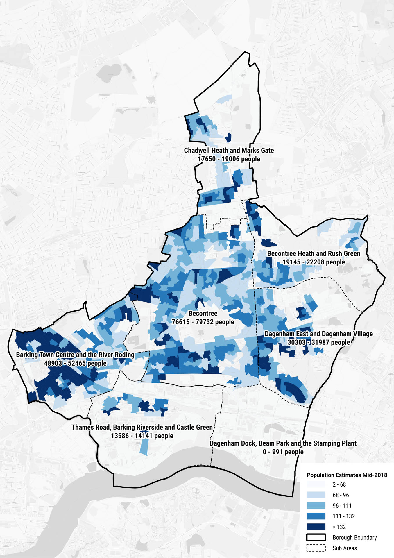
Figure 02: Existing population density in Barking and Dagenham’s seven sub-areas (based on Mid-2018 estimates by hectare)
5. WORKSHOPS AND ENGAGEMENT
5.1 Overview
5.1.1 There has been ongoing engagement with internal service providers, external service providers and relevant agencies throughout the development of this IDP. The aim of this process was to gather technical information relating to the existing levels of infrastructure, their functionality, and what future considerations would be required in order to meet the proposed scale of growth in the Borough. During the first stage of this project, Royal Haskoning DHV provided technical advice to Troy Planning + Design, to ensure that the information provided by providers was accurate and sufficiently detailed. Key dates are as follows:
- Council service providers and external service providers were contacted in September
- Follow-up workshops with internal service providers were held on 5th March
- Further meetings were held with external service providers and Duty to Cooperate partners in April-May
5.1.2 Strategic site developers were contacted as part of the engagement process in June 2020. Service providers were asked to provide technical information relating to the The key findings from these discussions are outlined in the main body of this chapter. It is important to note that in some cases, service providers were unable to provide detailed responses, due to the incompletion of internal demand/need assessments.


5.2 Key findings: physical infrastructure
- Currently, 9,335 properties are at risk of flooding within the Borough; approximately 4% of these properties are at a high risk of flooding.
- Additional wastewater infrastructure is funded through Infrastructure Charges that developers pay to Thames Water on occupation of the development.
- There is a significant level of traffic congestion in Barking Town Centre – an area earmarked for growth over the Plan period.
- There are deficiencies in north-south transport connectivity across the Borough; and high cost /lack of funding for major transport infrastructure inhibits new provision.
- There are opportunities to link fragmented walking and cycling routes, through the implementation of the London-wide strategic cycle network.
- There have been a number of aborted transport projects (e.g. the DLR extension) or scaled-back interventions (e.g. ELT buses – downgraded from trams).
- There is a discrepancy between the perception of required car parking provision between residents and developers.
- With regard to electricity infrastructure requirements, it is acknowledged that the high level of network utilisation is a city-wide concern.
- It was expected that 21,134m of gas mains would be replaced in the Borough in 2017/18.
- Barking and Dagenham is covered by Openreach’s expansion of their FTTP Ultrafast Broadband network expansion.
- With regard to future broadband capabilities, it has been highlighted that new fibre spine cables will be required to link Openreach locations to development sites throughout the Plan periodThere are two district energy schemes currently in development at Becontree and Barking town centre sites.
- Initial scoping work for a number of new district energy networks is currently being undertaken within the Borough.
- The East London Waste Authority (ELWA) is the statutory Waste Disposal Authority for the Borough and many of the services which ELWA is responsible for are delivered by Renewi.
- With regard to publicly accessible waste infrastructure, Frizland Lane Re-use and Recycle Centre (RRC) is the only RRC within the Borough although it is also served by RRCs in the neighbouring boroughs of Havering, Redbridge and Newham.
5.3 Key findings: social infrastructure
- Service providers voiced concern over the high turnover of residents within the Borough. Retaining and solidifying the local community (including skilled workers) will be a key challenge throughout (and beyond) the Plan period.
- Service providers state that the emerging Local Plan provides an opportunity for the Borough to respond to all community needs. In particular, there is scope to improve the lives of the elderly, faith communities, youths, and domestic abuse survivors living and working in the area through effective Borough-wide planning.
- At present, the Borough can meet Early Years’ demand, however it is recognised that there may be increased pressure on the future availability of places due to changes in the Early Years’ funding system.
- There is a lack of primary schools in the northern and southern areas of the Borough.
- There is a higher proportion of secondary schools in the west of the Borough in comparison to the east.
- There are current demand issues for both primary and secondary schools within the Barking town centre area.
- There is an additional need for SEN provision in the centre of the Borough.
- Adult learning (AL) providers should seek opportunities to maximise the usage of existing built facilities.
- Barking and Dagenham is currently facing a shortage of young GPs. The Borough has a high proportion (40%) of GPs aged 60 or over. This may translate into an overall shortage in GPs in the Borough over the coming years, as GPs reach retirement.
- 34.5% of rated GP surgeries in Barking and Dagenham require improvement or are deemed inadequate.
- A new healthcare facility of 2,800sqm will be developed in the Barking Riverside area in order to cater for residents.
- Dagenham Police Station is the only station which provides 24/7 front counter access in the Borough.
- Dagenham Fire Station was extensively improved in 2016 as part of a £57 million project to build nine new stations in London.
There is currently one ambulance station in the Borough which is managed by the NHS. - There are a total of 19 community centres and 7 children’s centres within Barking and Dagenham.
Developer contributions (S106) and CIL are the primary funding mechanisms for the Borough’s community centres. - The Community Infrastructure Plan estimates that the cost of community infrastructure required to support growth in the Borough to 2025 equates to £3,600,000 for libraries (including revenue costs for Barking Riverside Library and ongoing maintenance fees of the existing estate.
- The Parks and Open Space Strategy (2017) highlights that there are deficiencies of accessible play provision across all age groups within the Borough, particularly in the wards of Becontree, Whalebone, Albion, Eastbury, Heath, Longbridge, Parsloes, Valence and Village wards.
- There is a deficiency of play spaces for children aged 0-5 years old across the whole Borough with the exception of parts of Gascoigne ward.
- Indoor sports provision is provided in the form of two leisure centres and twenty sports halls.
- There is an undersupply of junior rugby pitches within the Borough.
5.4 Key findings: green infrastructure
- Green infrastructure provision is failing to match the projected level of growth (and future need) in the Borough due to a lack of funding.
- Developer contributions (S106) and CIL help to contribute towards open space provision.
- It is likely that there will be an increase in demand for food growing spaces. However, the exact number of additional allotment plots required is currently unknown.
- Burial capacity within the neighbouring borough of Redbridge may provide opportunities to address Barking and Dagenham’s undersupply of burial spaces.
6. PHYSICAL INFRASTRUCTURE

Figure 03: Thames Barrier [source]
This section of the IDP presents in detail the infrastructure requirements associated with ‘physical infrastructure’, covering:
- Flood Defences
- Water Supply and Wastewater
- Transport
- Utilities
- Telecommunications (and Internet)
- District Energy Network
- Waste
- Wholesale Markets
6.1 Flood Defences
INTRODUCTION
6.1.1 The Council is the Lead Local Flood Authority, responsible for managing flood risk in the Borough. The Council is also the Local Highways Authority, and as such responsible for managing flood risk associated with the Council’s highway assets. The Environment Agency is responsible for managing flood risk associated with the five Main Rivers, including the River Thames.
6.1.2 The Strategic Flood Risk Assessment [14], [15] (SFRA, 2017) and Local Flood Risk Management Strategy [16] (LFRMS, 2017) highlight the River Thames as the main source of tidal flood risk to the Borough, with the River Roding and Beam River the primary sources of fluvial flooding.
CURRENT PROVISION
6.1.3 Currently, 9,335 properties are at risk of flooding within the Borough. Of these, 356 are at high risk (greater than 3.3% [1 in 30 chances of flooding each year]).
6.1.4 The River Thames floodplain which lies south of the A13 is highly dependent upon manmade defences for flood protection. This land lies within Flood Zone 3 and lies downstream of the Thames Barrier, therefore gaining no defensive benefits from the barrier. The River Roding does however benefit from the Barking Barrier, as the barrier effectively keeps flood levels down during spring tides. Within these areas, development control areas principles (i.e. opportunities to reduce overall flood risk through the layout and form of the proposed development, relocating existing development to land with lower flood probability and restoring functional floodplain) will apply to both defended and undefended areas, however the management of identified flood risk may vary.
6.1.5 With regard to the proposed strategic sites in the emerging Local Plan, review of Environment Agency Flood Zone data places sites in the Barking Town Centre and the River Roding, Thames Road, Barking Riverside
and Castle Green and Dagenham Dock, Beam Park and the Stamping Plant in Flood Zone 3 (land assessed as having a 1 in 100 or greater annual probability of river flooding (>1%), or a 1 in 200 or greater annual probability of flooding from the sea (>0.5%) in any year.
INFRASTRUCTURE PLANNING CONSIDERATIONS
6.1.6 Modelled breaches of the Thames Barrier in the LFRMAS indicate that there is an extreme risk to the majority of Barking Town Centre, Creekmouth, Dagenham Dock, and land to the south of the A13. The Barking Creek Flood Barrier is considered to be key flood management infrastructure for Barking and Dagenham.
6.1.7 The LFRMS stated that the area to the north of the Barking Bypass (encompassing the areas around Gascoigne Road, Boundary Road and The Shaftesburys) – an area associated with the River Roding – is currently undefended. Furthermore, the Environment Agency indicate that the west of the Borough (between the River Roding and the A406) is at risk of reservoir flooding from the Basin Reservoir in Wanstead and the Perch Pond Reservoir in Wanstead Park. Similarly, Choats Manor Way in the east of the Borough is at risk of flooding from the Washlands Flood Storage Area. There is a substantial risk of surface water flooding at Creekmouth, Barking Reach and land west of Barking Station. As outlined in the NPPF [17], “all plans should apply a sequential, risk-based approach to the location of development.” This ensures that new development is steered to areas with the lowest risk of flooding. The SFRA affirms that a Sequential Test must be applied for all new development within the Borough. Sites located within Flood Zones 2 and 3 will be required to pass the Exception Test via a Flood Risk Assessment and should be regarded as priority areas for flood protection and mitigation.
6.1.8 Barking and Dagenham forms part of the Roding, Beam and Ingrebourne catchment partnership, whom prioritise physical modifications for urbanisation and flood protection [18]. The Thames Estuary 2100 (TE2100) Plan [19], published by the Environment Agency, provides recommendations for flood risk management for London and the Thames Estuary up to 2100. The TE2100’s vision for Barking and Dagenham is to provide opportunities for local realignment and landscaping along the Thames frontage as a result of changes made to flood defences. This includes a reduced dependency on vertical walls where possible, to provide more robust and sustainable defences with access for maintenance. In addition, there is scope for new open spaces, which can serve as flood storage and environmental improvement areas. The TE2100 Plan’s vision also seeks to improve the river frontage on the River Roding.
6.1.9 The Environment Agency are currently in the process of developing a series of Riverside Strategies, which effectively include a masterplan of a set area. Once adopted, these strategies will help to improve flood risk management in the vicinity of the River Thames, will create better access along the riverside and will improve the riverside environment.
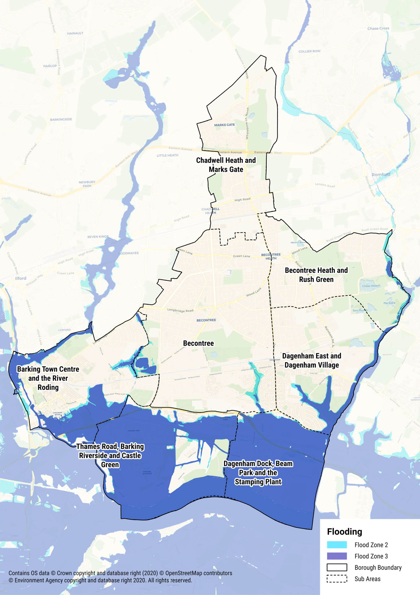
Figure 04: Flood risk in Barking and Dagenham
6.2 Water Supply and Wastewater
6.2.1 Essex and Suffolk Water (ESW) is the statutory water supplier, and Thames Water the sewerage infrastructure provider for the Borough dealing with wastewater. The Borough is located within the Essex Water Resource Zone (WRZ) [20 – ESW Final Water Resources Management Plan, August 2019], which serves approximately 1.65 million customers.
6.2.2 ESW has published a Water Resources Management Plan in 2019 (WRMP19), in line with their requirement to produce a plan every five years. The purpose of this document is to demonstrate their ability to maintain an efficient, sustainable and secure supply of water over their planning period from April 2020 to March 2060.
6.2.3 Intrinsic water resources for the Essex Area are the rivers Chelmer, Blackwater, Stour and Roman River, which support pumped storage reservoirs at Hanningfield and Abberton – with treatment works near Langford, Langham, Hanningfield and Layer. Water is also supplied into the Essex area via: raw water bulk supply from the Chigwell; raw water bulk supply from Thames Water Utilities’ Lea Valley Reservoirs; and the Ely Ouse to Essex Transfer Scheme. The Chigwell raw water bulk supply provides approximately 20% of the potable water in the WRZ, once processed. Approximately 2% of the total water supplied in the Zone is derived from groundwater via a chalk well and additional sources in the South/South West of the zone.
6.2.4 The water supply network is a highly integrated one, with a large degree of flexibility for directing water supply to where demand requires.
6.2.5 Thames Water produces a Water Resource Management Plan (WRMP) every five years. The current version is the Plan adopted in 2014 (WRMP14), covering a plan period from 2015-2040. At current, Thames Water’s 5 Year Draft Plan (2020 to 2025) has been drafted and has received ‘draft determination’ feedback from Ofwat. In response, Thames Water has reviewed and responded to the regulator. To date, the Plan has not yet been published. Thames Water supplies an area covering 13,000 sqkm, with provision split into six water resource zones (WRZs), of which only some areas within Barking and Dagenham fall into the ‘London’ Thames Water WRZ. Thames Water’s five-year business plan for 2020- 2025 outlines its strategy with regards to wastewater and sewerage, the main targets of which are:
- Reduce internal sewer flooding by 20% (to 995 incidents by 2024/2025) – digitising the sewer network by installing up to 200,000 low cost blockage sensors to facilitate sophisticated network modelling, to better inform where to focus sewer cleaning. Over 1,000 sensors have already been installed.
- A commitment to reduce pollution by 30% (to 19.5 incidents per 10,000km of sewer by 2024/2025) [21]
CURRENT PROVISION
6.2.6 The Environment Agency has designated Barking and Dagenham as an area of ‘Serious Water Stress’ [22], thus indicating that a serious stress level has been placed on the water environment by the use of water through abstraction, discharge and management of storage. Despite this, ESW estimates that there will be an efficient and sustainable supply of water from 1st April 2020 up to 31st March 2060. The continued roll-out of ESW’s ‘Every Drop Counts’ will help to reduce water usage within the Borough.
6.2.7 Thames Water has committed to reducing leakage to 606 million litres a day by 2020. However, leakage targets have been missed for the last two years. There was an initial plan to install 441,000 smart meters by 2020 but this has now been reduced to 300,000.
PLANNED INFRASTRUCTURE CONSIDERATIONS
6.2.8 As of 1st April 2018, all off site water and wastewater network reinforcement works necessary as a result of new development will be delivered by the relevant statutory undertaker. Local reinforcement works will be funded by the Infrastructure Charge (a fixed charge for water and wastewater for each new property connected). Strategic water and wastewater infrastructure requirements will be funded through water companies’ 5-year cycle investment programmes, known as Asset Management Plans. Requirements for additional water and wastewater infrastructure will be determined at the time of individual planning applications, or, with larger regeneration allocations, in pre-application discussions with the service providers. Water providers will require an element of certainty of an application coming to fruition before they will commit to any changes to their infrastructure provision.
6.2.9 As part of an Inset Agreement, SSE Water will supply water supply and sewerage services to Barking Riverside phases 2-4 [23 – Variation of SSE Water Limited’s appointment to include Barking Riverside stages 2-4], which will include potentially up to 10,000 homes. Water will be supplied via a bulk supply agreement with ESW (Northumbrian Water) and a bulk discharge agreement with Thames Water. The development will also include a surface water discharge system, which will be owned by the developer, rather than SSE Water. There were no existing infrastructure assets in the area prior to SSE Water’s involvement in the development, and, as the statutory supplier, they will provide the associated infrastructure as part of the agreement.
6.2.10 Thames Water encourage all developers to consider the net increase in water and wastewater demand to serve their developments and also off- site impacts to the network. Developers are encouraged to use Thames Water’s pre-planning service to establish whether there is capacity in water and/or wastewater networks to serve their development.

Figure 05: Essex and Suffolk Water supply area [Source]
6.3 Transport
INTRODUCTION
6.3.1 Responsibility for transport infrastructure within the Borough varies. The majority of highways are managed by the Council, with some primary routes are managed by TfL, which form part of the TfL Road Network. Public transport services are generally the responsibility of TfL, Network Rail and the private rail operators. Delivery of schemes and infrastructure improvements are identified and planned for by those organisations, who together forge a strategic view of future growth and use.
6.3.2 The Mayor’s Transport Strategy (MTS, 2018) [24] identifies that behavioural changes and a modal shift towards sustainable transport use are key in shaping future successful transport systems in London. Furthermore, the increased use of public transport plus increased walking and cycling are critical. The aim is that by 2041, 80% of all trips in London are to be made on foot, by bicycle or by public transport.
6.3.3 In January 2019, the Council published its Local Implementation Plan 3 (LIP3) [25] as a strategy for delivering improvements to the transport system in the Borough. LIP3 reflects the MTS (2018) – and the driving principles include regeneration, community, health and wellbeing. The Council recognises that road traffic volumes in Barking and Dagenham have increased by 10% from 2012 to 2016 and that of all daily trips made between 2014/2015 – 2016/2017, 44% in Barking and Dagenham were made by car. Furthermore, the number of people killed and seriously injured on the Borough’s roads has increased by 49% in recent years.
6.3.4 In order to address the key issues identified, the Council has identified several key targets in LIP3. These include:
- Increasing the walking, cycling and public transport mode share from 55% to 72% by 2041;
- Increasing the percentage of people achieving at least 20 minutes of active travel a day from 18% to 70% by 2041;
- Ensuring no deaths and seriously injured (KSI) casualties from road collisions by 2041;
- Achieving a 5-10% reduction in the volume of traffic on the Borough’s roads by 2041;
- Reducing CO2, NOx, and particulate emissions significantly by 2041;
- Increasing average bus speeds by between 5% to 15% by 2041;
- Doubling the number of daily trips made by public transport by 2041.
CURRENT PROVISION
6.3.5 The Borough is well serviced by an extensive east to west rail network, comprised of National Rail services, TfL Rail and both London Underground and London Overground. There are three main railway stations, five tube stations and one Overground station. There are a number of bus routes within the Borough, as well as a number of night bus services in operation. Further information on bus routes serving the Borough’s sub-areas can be found in Chapter 6.3. There are 350 bus stops in the Borough and 93% of these are classed as being fully accessible by disabled passengers. However, it is acknowledged that there are poor north/south public transport links, as well as weaker links to orbital routes around London.
6.3.6 Existing National Rail services are operated by Trenitalia c2c between London Fenchurch Street and Southend, known as Essex Thameside. Trenitalia c2c manage Barking and Dagenham Dock railway stations.
6.3.7 Existing rail freight yards are located at Fords Dagenham, DHL Box Lane depot (off Renwick Road) and DB Schenker’s logistic centre accessed off Ripple Road. The DB Schenker site has a direct connection with High Speed 1 and the Channel Tunnel allowing it to handle international rail freight traffic bound for London. The high-speed line is used to bring perishable food from Valencia in Spain to Barking via the Channel Tunnel.
6.3.8 The Borough is predominantly flat – which is a positive attribute for encouraging walking and the use of cycling routes. LIP3 identifies that the Borough is served by a number of on and off-road cycle routes, as well as walking routes/facilities. In terms of cycling infrastructure this includes: 7km of ‘Greenways’ routes; local ‘Quietways’; Cycle Superhighway 3; and cycle parking facilities. There is also a 16km Rights of Way network, the Thames Path, eight ‘Just Walk’ routes and a network of designated ‘safe routes to schools’. Presently, some of the routes are fragmented and this provides an opportunity to provide a more comprehensive and linked network. A consultation on proposals to link Ilford and Barking Riverside closed in August 2019. If given the go-ahead, these proposals are likely to contribute to safer and more accessible cycling and walking networks [26].
6.3.9 There are 396 km (248 miles) of roads in Barking and Dagenham, including the A12 and A13 which links Barking and Dagenham to the London Inner Ring Road and to the North Circular. LIP3 identified that vehicular travel is relatively popular within the Borough. As a result, Barking and Dagenham suffers from poor air quality and traffic congestion, as well as having some of the busiest roads in London.
6.3.10 Within East London, it is recognised that the River Thames is an under- utilised transport network for commuters. There is however significant industrial freight activity around Barking Reach.
INFRASTRUCTURE PLANNING CONSIDERATIONS
6.3.11 In terms of secured future provision, construction has begun on the Barking Riverside extension which will add 4.5km to the London Overground Gospel Oak to Barking line. There will be a new station at Barking Riverside to serve the extensive housing development in this area. It is expected that train services will start in December 2021 [27]. Within the extension, passive provision exists for a second station on the extension to serve Castle Green that could be accessed from Renwick Road. This proposed station could provide better access to public transport for potential development sites in the Castle Green area.
6.3.12 More strategic projects such as the creation of the Elizabeth Line (formerly known as Crossrail), will have implications for Barking and Dagenham. Chadwell Health, in the north of the Borough, has been included as a station stop on this line. It is expected that a full service will start in late 2020-early 2021 [28]. TfL is also currently upgrading the District Line (which services all of the tube stops in the Borough) through the Four Line Modernisation project. This includes new trains, new track and drainage, and a new signalling system. The project is expected to be completed in 2023 [29].
NATIONAL RAIL
6.3.13 Anticipated passenger growth on the Essex Thameside route (serving Barking and Dagenham Dock) to both 2023 and 2043 can be met through further train lengthening of services to 12 carriages. Should growth projections exceed that forecasted, capacity improvements could be implemented earlier. Trenitalia c2c are committed to introduce an additional 60 carriages to their fleet in 2021 to meet increased demand and investment of circa £105M.
RAIL FREIGHT
6.3.14 As part of the work underway on the Barking Riverside Extension the track layout at Ripple Lane has been modified. The changes enable the existing short sidings to be converted to form a nodal freight yard capable of accommodating longer freight trains up to 775m in length. Longer freight trains increase the utilisation of the North London Line, allowing additional passenger services for Overground services.
DOCKLANDS LIGHT RAILWAY EXTENSION
6.3.15 TfL is currently considering options to extend the DLR from Beckton to Thamesmead. Whilst the plans do not impact the Borough directly, there may be opportunities to extend the DLR north to Barking and Ilford in the future.
6.3.16 A previous extension of the DLR from Beckton to Dagenham Docks was cancelled. In place of this, the extension of the London Overground provides access to Barking Riverside. Extending the Overground from Barking Riverside to Thamesmead would require a major alteration to the existing extension as the terminal station is at high level and so not compatible with a tunnelled crossing of the River Thames.
A13 IMPROVEMENTS
6.3.17 In September 2019 TfL submitted a bid to the Department for Transport (DfT) for funding improvements to the major road network in London. The total bid for ten schemes was for £375M with the funding for each scheme would be between £20M and £50M. The bid included a bid for a major asset renewal of the A13 Lodge Avenue Flyover. If the bid were successful, this would enable the existing temporary steel flyover to be replaced with a longer-term solution.
6.3.18 TfL and the Council have investigated the option of replacing the section of the A13 between Lodge Avenue and Renwick Road with a 1.3km road tunnel. This project, known as the A13 Riverside Tunnel would address existing traffic congestion and would allow for the redevelopment of the Castle Green area. It is understood that TfL is supportive of the principle of the scheme, but the proposals are not part of the current TfL Business Plan.
MARITIME INFRASTRUCTURE
6.3.19 In May 2018 the GLA published a draft of the Safeguarded Wharves Review. It included an assessment of which wharves were to be safeguarded, retained or released. In the Borough, Alexanders Wharf was recommended for safeguarding and Welbeck Wharf was recommended for release. A list of the wharves,
owners and uses is provided in Table 05. In accordance with this, core Objective 01 of the Draft South East Marine Plan (2020) [30] states that “infrastructure is in place to support and promote safe, profitable and efficient marine businesses”.
6.3.20 There are a number of existing port facilities in the Borough along the River Thames and Roding. A major wharf in Dagenham is the Ford engine manufacturing plan that exports engines to other Ford plants in Europe. Recent reports suggest the plant is under significant pressure due to uncertainties surrounding Brexit [31]. This site also receives, and stores imported Ford vehicles prior to distribution within the UK.
6.3.21 Other significant facilities include Stolthaven Terminal, which receives liquid chemical deliveries by ship prior to distribution across London and the region by road. Many wharves deal with construction and demolition materials, including recycling. For example, Dagenham Wharf is owned by CEMEX (concrete producers) and Hanson who handle aggregates for the construction industry. The 9.25 acre Welbeck Wharf site in River Road was purchased and released in 2018 as part of a consolidation scheme as part of strategic land use change.
| Facility | Status | Location | Owner/Operator | Description | Average tonnage
2014-2018 (Tones Per Annum) |
| Alexanders Wharf | Safeguarded | Barking | ELG Haniel Metals Ltd | Metal recyclate | 5,000 tpa |
| Amey’s Jetty | Safeguarded | Dagenham | Hanson Aggregates | Bulks | Unknown |
| Barking Riverside | Not safeguarded | Dagenham | Barking Riverside Ltd. | Potential site for Thames Clipper passenger services to Canary Wharf | N/A |
| No. 7 Jetty | Not safeguarded | Dagenham | Cemex | Formally Dagenham Docks | |
| No. 8 Jetty | Safeguarded | Barking | – | Bulks | – |
| No. 1 Western Extension | Safeguarded | Dagenham | Eurovia Roadstone | Aggregates | 113,000 tpa |
| No. 2 Jetty | Not safeguarded | Dagenham | – | Formally Dagenham Docks | |
| No. 4 Jetty | Safeguarded | Dagenham | Hanson | Aggregates | 1,031,000 tpa |
| Debden Wharf | Not safeguarded | Barking | McGrath Group | Waste | – |
| DePass Wharf | Safeguarded | Dagenham | Mixit (Modern Mix) | Aggregates and concrete products | Victoria Stone and DePass have combined throughput
of 500,000 tpa |
| Docklands Wharf | Safeguarded | Barking | S. Norton & Co. Ltd | Metal recyclate | 95,000 tpa |
| East Jetty | Safeguarded | Dagenham | Van Dalen UK Ltd. | Metals and other recyclate | 192,000 tpa |
| Fords Dagenham Terminal | Safeguarded | Dagenham | Ford Motor Company Ltd. | Vehicles | 674,000 tpa |
| Steel (Kierbeck) Wharf | Safeguarded | Barking | H Sivver Ltd. | Construction, Demolition and Excavation (C,D and E) waste, aggregates and project cargos | – |
| Pinns Wharf | Safeguarded | Barking | Pinns Wharf Ltd. | Metal recyclate | 70,000 tpa |
| Rippleway Wharf | Safeguarded | Barking | McGrath Group | Aggregates, Construction, Demolition and Excavation (C,D&E) waste | 40,000 tpa |
| Dagenham Wharf | Not safeguarded | Dagenham | Cemex | Aggregates | 459,000 tpa |
| Thunderer Jetty | Safeguarded | Dagenham | Stolthaven Dagenham Ltd | Liquid bulk storage (fuel, gas oils, vegetable oils) | – |
| Victoria Stone Wharf | Safeguarded | Barking | Mixit (Modern Mix) | Aggregates and concrete products | Victoria Stone and DePass have combined throughput
of 500,000 tpa |
| Welbeck Wharf | Proposed to be released from Safeguarded Status as part of the London Mayors 2018 Safeguarded Wharves Review | Barking | – | – | |
| Pinnacle Terminal | Safeguarded | Dagenham | TDG European Chemicals | Petroleum products, chemicals | 714,000 tpa |
Table 05: Overview of wharves in Barking and Dagenham (Port of London Authority, 2020)
6.3.22 An assessment of future demand for river traffic was undertaken in 2016. It included common freight such as construction materials, sugar, waste, vehicles, agricultural bulks steel and petroleum products.
LOCAL IMPLEMENTATION PLAN – PLANNED PROVISION
6.3.23 LIP3 states that Barking and Dagenham is London’s next ‘big growth story’, particularly with the construction of Barking Riverside in the south of the Borough. It is recognised however that this growth has the potential to exacerbate existing issues regarding congestion and air pollution. As mitigation, the Plan states that the Council will adopt a Healthy Streets approach, whereby new strategies are required to put people and their health at the heart of decision-making [32]. In line with this, all new developments will be required to be in line with the Mayor of London’s seven transport principles of ‘Good Growth’ [33] and the clean air goal within DEFRA’s 25-Year Environment Plan (2018) [34]. In order to facilitate that growth, LIP3 states that new development in the Borough will be dependent on improvements to transport infrastructure and services.
6.3.24 LIP3 includes a three-year programme of investment for funding secured through TfL’s Healthy Streets funding, which will support walking, cycling and public transport initiatives. This funding is detailed in Table 06.
| Funding Type | Programme | 2019/20 Confirmed | 2020/21 Indicative | 2021/22 Indicative |
| Formula | Corridors, Neighbourhoods and Supporting Measures | £1,377,000 | £1,377,000 | £1,377,000 |
| Local Transport Fund | £100,000 | £100,000 | £100,000 | |
| Discretionary | Liveable Neighbourhoods | – | – | – |
| Borough Assets | £0 | TBC | TBC | |
| Strategic* | Bus Priority | – | – | – |
| Borough Cycling | – | – | – | |
| Other Healthy Streets | – | – | – | |
| TOTAL | £1,477,000 | £1,477,000 | £1,477,000 |
Table 06: LBBD Healthy Streets funding allocation: 2019/20 – 2021/22
* – Strategic schemes subject to separate allocations/bidding process with funding formally approved at the start
of each financial year.
6.3.25 In addition, the new Green Grid includes ‘A Routes’ which connect green infrastructure elements within the Borough and neighbouring boroughs, and ‘B Routes’ which connect local communities with local parks and connections to A Routes [35].
6.3.26 Further funding is also available from a range of other sources. This funding will contribute towards new walking and cycling infrastructure, improvements to Barking Town Centre and other transport upgrades across the Borough.
| Funding Type | Programme | 2019/20 | 2020/21 | 2021/22 |
| Council Capital/ Revenue | Highways Improvement Programme | £2,920,000 | TBC | TBC |
| GLA | Green Capital Grant | |||
| (The Ripple Nature Reserve and Greenway) | £397,000 | – | – | – |
| Heritage Lottery Fund (HLF) | Barking Town Centre Heritage Project | £500,000 | £370,000 | £275,000 |
| Developer Funding (e.g. S106/CIL) | Various highways / public realm improvements | TBC | TBC | TBC |
| TOTAL | £3,817,000 | £370,000 | £275,000 |
Table 07: Alternative funding sources for LBBD’S Healthy Streets: 2019/20 – 2021/22
6.3.27 For full details on all planned transport infrastructure projects in the Borough, please view Chapter 9.
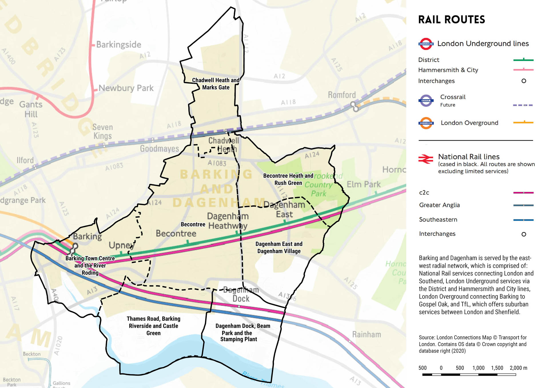
Figure 06: Rail routes and stations within Barking and Dagenham

Figure 07: Road network within Barking and Dagenham

Figure 08: Cycle lanes and cycle parking facilities within Barking and Dagenham

Figure 09: PTAL scoring across Barking and Dagenham in 2015
6.4 Electricity
INTRODUCTION
6.4.1 National Grid Electricity Transmission (NGET) owns and maintains the electricity transmission system in England. Within London, the South East and the East of England, electricity is distributed from National Grid sites and local energy generators to customers through the distribution networks, which are owned and operated by UK Power Networks (UKPN).
CURRENT PROVISION
6.4.2 It is considered that there is a good level of available capacity within the Borough. At present, a 400kV and 275kV power line runs in an east-west direction through the Borough, delivering an energy supply to the localised distribution networks.
6.4.3 As a general rule, NGET will undertake any necessary improvements to the system (to provide supplies to the local distribution network) are as a result of an overall increased regional demand rather than site specific requirements.
INFRASTRUCTURE PLANNING CONSIDERATIONS
6.4.4 The current London Plan notes that the high level of network utilisation is a city-wide concern. This is due to the level of development required to accommodate anticipated population and business growth.
6.4.5 The Intend to Publish London Plan also considers that the increased uptake of electric vehicles and switch to electric heating systems; coupled with economic and population growth, will contribute to the growing electricity demand in London.
National and Regional Considerations
6.4.6 A draft business plan for period 2021 – 2026 was published in July 2019 that provides an overview of NGET’s role in providing a transparent, affordable and sustainable energy system. The value of the plan is £8.4bn over five years. An example of the investment being undertaken to strengthen the electric transmission within London is London Power Tunnels 2. This is a second phase of cable renewal that improves the connection between east and west London.
Figure 10: London Power Tunnel networks (1 and 2) [source]
6.4.7 NGET is also considering the implications for the network resulting from the switch to electric vehicles. In particular, the requirement for a national network of rapid charging points on the strategic road network. NGET proposes a network of 50 ultra-rapid EV charging points, affordably implemented along the existing motorway network. Upgrading grid connections will be a key requirement to ensure that this plan can be operationalised. The estimated costs of these works are £0.5 billion – £1 billion. It should be noted that NGET’s plans align with the Mayor of London’s zero-carbon emission vision, as outlined in the electric vehicle infrastructure delivery plan (EV-IDP [36]). The EV IDP outlines a number of recommendations, including the roll-out of rapid chargers in London’s town centres and the development of five new rapid charging hubs across London (as shown in Figure 11).
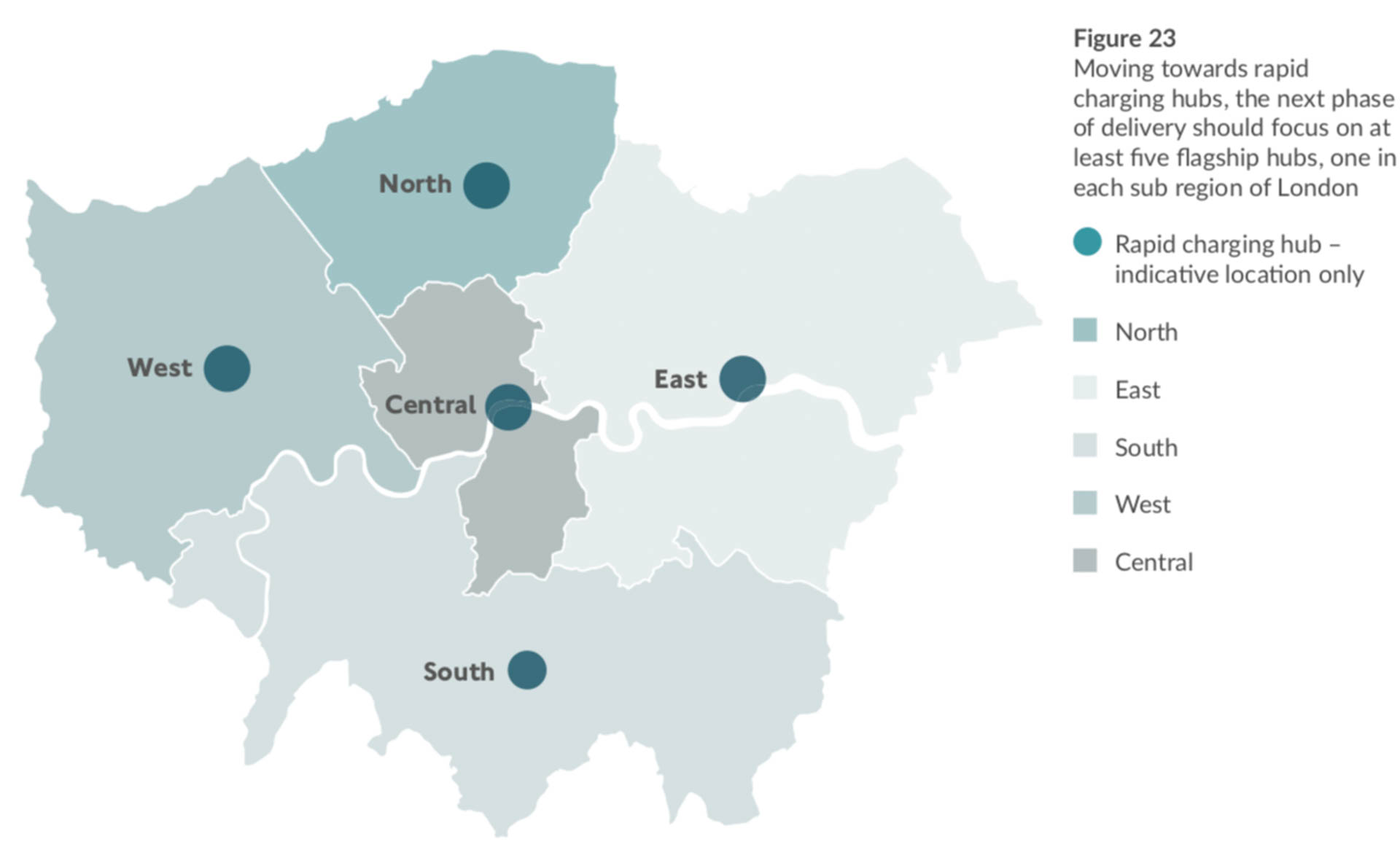
Figure 11: Proposed rapid charging hub locations, as set out in the London electric vehicle infrastructure delivery plan (2019)
Local Considerations
6.4.8 UKPN operates on a customer-driven model. As a general rule, local electricity capacity can accommodate additional demand for 2,000- 3,000 homes per site. Site proposals which exceed the 2,000-3,000 home threshold will be subject to further engagement between UKPN and the developer. Typically, the developer will be liable to provide financial contributions under the ‘Second Comer Regulation’, to ensure that the local distribution network has sufficient capacity to accommodate the new development.
6.4.9 Based on the proposed growth within the emerging Local Plan (external engagement with UKPN took place in May 2020. Electrical requirements based on LBBD’s April 2020 trajectory), UKPN state that the following works will be required within each of the major growth areas: Thames Road and Barking Riverside (operated by London Power Networks).
6.4.10 Within the major development sites, high voltage/low voltage diversions of the substations will be required to facilitate to these sites. With regard to the infill areas, connection and reinforcement works may be required due to the size of the land parcel. Any redevelopment would need to consider the high voltage underground cables and 132Kv towers within the area.
Castle Green and Barking Town Centre (operated by London Power Networks)
6.4.11 Redevelopment within the area would require multiple high voltage/low voltage diversions to move the existing substations. Redevelopment within the existing capacity would see relocation & connection costs only. Any increase in demand will likely drive network reinforcement.
Londoneast-UK employment site (operated by Eastern Power Networks)
6.4.12 Planned growth on this site would require reinfrocement and new connections/diversions.
Chadwell Heath and Marks Gate Sub-Area (operated by Eastern Power Networks)
6.4.13 Planned development within this sub-area is likely to require connection and diversion costs. However, due to the quantity of planned infill, additional reinforcement works may also be required.
Dagenham Dock, Beam Park and the Stamping Plant Sub-Area (operated by Eastern Power Networks)
6.4.14 Existing District Network Operator primary substations have ongoing load issues, therefore any substantial development will require network reinforcement.
6.4.15 Please note, for security reasons, we were unable to map the local electricity distribution network (operated by UK Power Networks). Therefore, mapped assets include only those owned by National Grid.

Figure 12: National Grid electrical assets in Barking and Dagenham
6.5 Gas
INTRODUCTION
6.5.1 As depletion of North Sea gas reserves continue, the UK is increasingly depending on natural gas imports of liquified natural gas (LNG) and long-distance pipelines from the global market [37]. In 2018, net UK imports increased by 11% in comparison to 2017 levels [38]. It is acknowledged that longer-term (2030 onwards) natural gas trends in the UK power and heat generation mix are uncertain [39], as the future of natural gas production is dependent on the direction of UK government policy.
6.5.2 National Grid Gas plc (NGG) owns and operates the high-pressure gas transmission system in England, Scotland and Wales. In the UK, gas leaves the transmission system and enters the distribution networks at high pressure. It is then transported through a number of reducing pressure tiers until it is finally delivered to consumers. There are eight regional distribution networks, operated by four owners. Cadent Gas Ltd is the network operator for the North London network, within which Barking and Dagenham falls. Figure 13 reveals the distribution networks’ regions by individual operator [40].
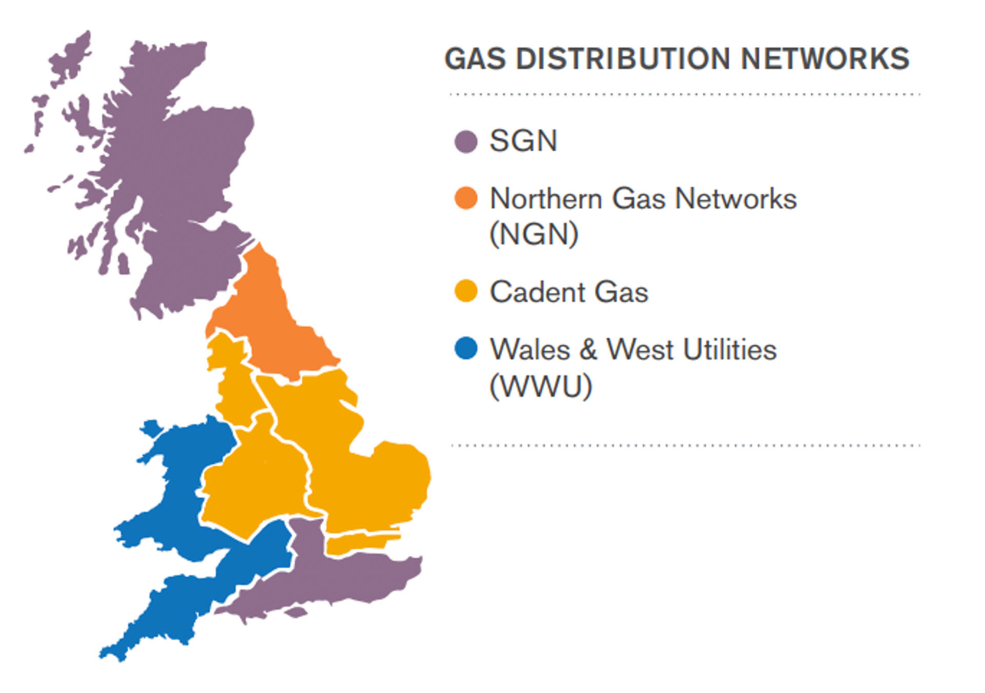
Figure 13: UK-wide individual operator distribution networks
CURRENT PROVISION
6.5.3 In 2017, Cadent invested £90 million to upgrade 390km of metal gas pipes in the North London region. It was expected that 21,134m of gas mains would be replaced in LBBD in 2017/18 [41].
INFRASTRUCTURE PLANNING CONSIDERATIONS
6.5.4 Due to ongoing uncertainties regarding future gas production, combined with complexities surrounding the UK energy mix, it is difficult to assess specific future infrastructure requirements for the Borough. However, national and regional policies and emerging technological advancements do help to imply what the effects of changes to wider-level gas production might be for the Borough.
6.5.5 With regard to London-wide gas supplies, a large proportion of the Borough is situated within the London Riverside Opportunity Area. Within this in mind, the adopted London Plan states that ‘[…] partly because of improvements in operational efficiency, the industry is currently not expecting a general increase in gas demand. However, alongside the continuing programme of replacing old metal gas mains, local infrastructure improvements may be required to supply growth areas such as Opportunity Areas. This may also require the provision of new pressure reduction stations.’ It is therefore expected that local gas infrastructure improvements may be required in the Borough.
6.5.6 The draft London Plan acknowledges that ‘demand for natural gas in London has been decreasing over the last few years with a 25% reduction since 2000’. It is noted that both Cadent Gas and SGN (the operator for south London) are implementing gasholder de-commissioning programmes.
6.5.7 The recently published ‘Future Homes Standard’ consultation paper also has implications for future domestic gas use. If adopted, the new Homes Standard will see polluting heating systems (including gas boilers) banned from new homes by 2025, in replacement for new clean technology. This would be a requirement for proposed allocation sites with phased construction covering the mid-latter stage of the Local Plan period (2025- 2037).
6.5.8 In addition, the National Grid Grain LNG terminal is located 37 miles east of London. At current, it provides 20% of imported natural gas through a direct connection to European market [42]. National Grid is currently considering the decarbonising role gas could play by converting methane to hydrogen for industrial and residential use. It is envisaged that this site could operate as a fuel station operator in the future, providing compressed natural gas and hydrogen at LNF filling services to lorries and fleets at the LNG Grain Facility [43]. In turn, this may have future regional domestic implications for the uptake of hydrogen gas production.
6.6 Telecommunications and Internet
CURRENT PROVISION
6.6.1 The supply of telecommunications is managed by private companies; Virgin Media and British Telecom (BT) the two core providers of networks in the Borough.
6.6.2 Broadband coverage and speeds are very good in Barking and Dagenham [44], with 99.05% of residential and business premises having access to superfast broadband of 30Mbps and above; for the Borough as a whole, fibre coverage is at 99.1%. The national target for superfast broadband household availability by 2016 was 95% [45 – Ofcom Infrastructure Report 2014].
6.6.3 Within the emerging Local Plan’s allocation sites, Openreach has a predominantly copper network, in addition to small levels of fibre network. The current Openreach network consists of underground boxes and ducts and overhead plant. Connections to residential properties are made with cabling and telegraph poles. Virgin Media’s existing network is primarily covered by hybrid co-axial 3.0 cabling. Virgin Media are currently in the process of phasing out copper cabling and are also integrating phones to IP phones.
6.6.4 In December 2018, Barking and Dagenham was confirmed to be the 16th area in the UK to be covered by Openreach’s expansion of their FTTP (Fibre to the Premises) Ultrafast Broadband network expansion scheme [46]. This scheme forms part of plans to reach 3 million premises in the United Kingdom, by 2020, with speeds of up to 1Gbps. As of September 2019, the Borough is registered ‘Complete’ as part of Openreach’s FTTP Fibre First Towns, Cities and Boroughs Build Programme meaning the construction of the required exchange has largely been completed.
6.6.5 In addition, Openreach is contracted to deliver FTTP to 4390 homes across 38 new developments in the IG11, RM6, RM8, RM9 and RM10 postcodes.
6.6.6 Further aims of Openreach’s programme include:
- Upgrading city cabinets previously restricted by technical challenges or planning restrictions;
- FTTN (Fibre to the Node) and broadband cabinets for multi-dwelling units;
- Openreach network equity for competing BT internet providers.
6.6.7 Public Wi-Fi in community facilities and public buildings has been delivered by the Council. Barking and Dagenham offers free Wi-Fi at all of its libraries across the Borough.
6.6.8 In 2016, TfL delivered station Wi-Fi to 250 Tube and 79 Overground stations across the network, including Barking and parts of the Overground.

Figure 14: Status of Openreach’s FTTP Fibre First Towns, Cities and Boroughs Build Programme in Barking and Dagenham

Figure 15: Telecommunications and internet connection in Barking and Dagenham
6.7 District Energy Heating
INTRODUCTION
6.7.1 Policy 5.5 of the London Plan states that ‘the Mayor expects 25% of the heat and power used in London to be generated through the use of localised decentralised energy systems by 2025’. In order to achieve this target, the Mayor prioritises the development of decentralised heating and cooling networks at the development and area-wide levels, including larger scale heat transmission networks.
6.7.2 B&D Energy Ltd is a district energy company, wholly owned by the Council. It is an Energy Services Company (ESCo), supplying low carbon heat and electricity to specific schemes connected via buried heating networks an, where appropriate, private wire electricity networks. A combination of solar photovoltaics, combined heat and power (CHP) generators and back- up conventional boilers are used to generate electricity and heat, which is subsequently delivered through underground district heating pipes and a Private wire electricity network.
6.7.3 The process by which B&D Energy is approached by developers to provide decentralised energy varies. Commonly, discussions will begin during the planning application process; this is either through the pre-application process with the Council’s planning officers, or through dialogue with the consultants tasked with preparing the site’s Energy Strategy. Through the latter process, consultants – in accordance with the London Plan – are tasked with exploring the potential for heat networks within the local area.
CURRENT PROVISION
6.7.4 The emerging Local Plan states that ‘detailed heat mapping and energy master planning of the entire Borough has identified seven potential district energy opportunity areas. The largest of these is in Barking Town Centre’. These seven areas are currently being re-planned, with three on hold and a further number planned. The latest schedule is outlined in Table 8.
6.7.5 B&D Energy has two operational schemes. The first is Becontree (previously Dagenham Civic Centre), a development of 170 homes by Countryside Properties that is linked by a district heating network to a new Energy Centre at the Becontree Leisure Centre. The first phase of Barking town centre is also ready to start development. This is the redevelopment of the east side of the Gascoigne Estate into the Weavers Quarter, to provide 1,500 homes, together with a new primary school and secondary schools connected via a heat and electricity network. Currently, circa 400 homes are serviced from this first phase.
6.7.6 The Barking Town Centre proposal is planned to go ahead as detailed in the 2019/2020 Business Plan.
INFRASTRUCTURE PLANNING CONSIDERATIONS
6.7.7 In November 2019, B&D Energy were awarded £5 million in grant funding from the Department for Business, Energy & Industrial Strategy Heat Networks Investment Project. A key challenge for service providers is to develop viable schemes with sufficient core loads which are capable of being connected over a reasonable time-scale.
6.7.8 B&D Energy’s main proposal is to develop a Greater London Authority (GLA)-designated ‘Strategically Significant District Energy Network’, connecting 8,000 homes and 60,000sqm of commercial floor area into one local energy network in Barking town centre. The proposal involves installing approximately 2km of buried pipework, dependent on the above referred-to £5m capital grant from BEIS Heat Network Investment Project (HNIP). A new strategic-scale energy centre situated north west of Barking Town Centre will be linked to the existing energy centre on the Gascoigne East redevelopment site.
6.7.9 There will be a requirement to roll out a number of Strategically Significant Heat Networks (SSHN) across the Borough, replicating the SSHN planned for Barking Town Centre. These will be sized proportionally to the potential connected loads in each area. The development of these networks will also require energy centres sized to meet the loads in each area.
6.7.10 Future energy sources will be incorporated into B&D Energy’s heating networks including waste heat from industry and waste energy in order to phase energy to large scale and fully renewable zero carbon sources by 2050, in line with the Mayor of London’s ‘Zero Carbon London’ target47.
6.7.11 Until heat network opportunities are explored in more detail throughout Barking and Dagenham, it is difficult to estimate costs for the potential level of district energy infrastructure required over the Plan period. Future cost estimates are further complicated by the relative densities of opportunity areas, as denser areas will require significantly less network per connected load.
6.7.12 For reference, a typical linear metre of district heating (including trench and pipework works) costs approx. £2,000.
6.7.13 Based on the current and planned schemes outlined over the Plan period, a further capital expenditure of approx. £75 million is estimated. For the Barking Town Centre scheme alone, costs are expected to reach approximately £25 million.
For a list of all of B&D Energy’s proposed heat network schemes, please see Table 8 below.
| B&D Energy – District Energy Opportunity Areas | |||
| Phase | Name | Status | First Identified |
| PHASE A | Barking Town Centre | Ready to start development, HNIP funding awarded November 2019 | 2015 Heat Mapping |
| Becontree (previously called Dagenham Civic Centre) | Operational | ||
| Thames Road (previously called Thames – EETV) | Full energy master plan to be developed (scoping work commenced in 2019) | September 2019 meeting with Be First | |
| Marks Gate (previously called Chadwell Heath) | |||
| Dagenham East (Film Studios area) | |||
| PHASE B | Dagenham Dock (Markets area) | ||
| Castle Green | |||
| Chadwell Heath | |||
Table 8: District energy heat mapping schedule

Figure 16: Current provision of district energy networks in Barking and Dagenham
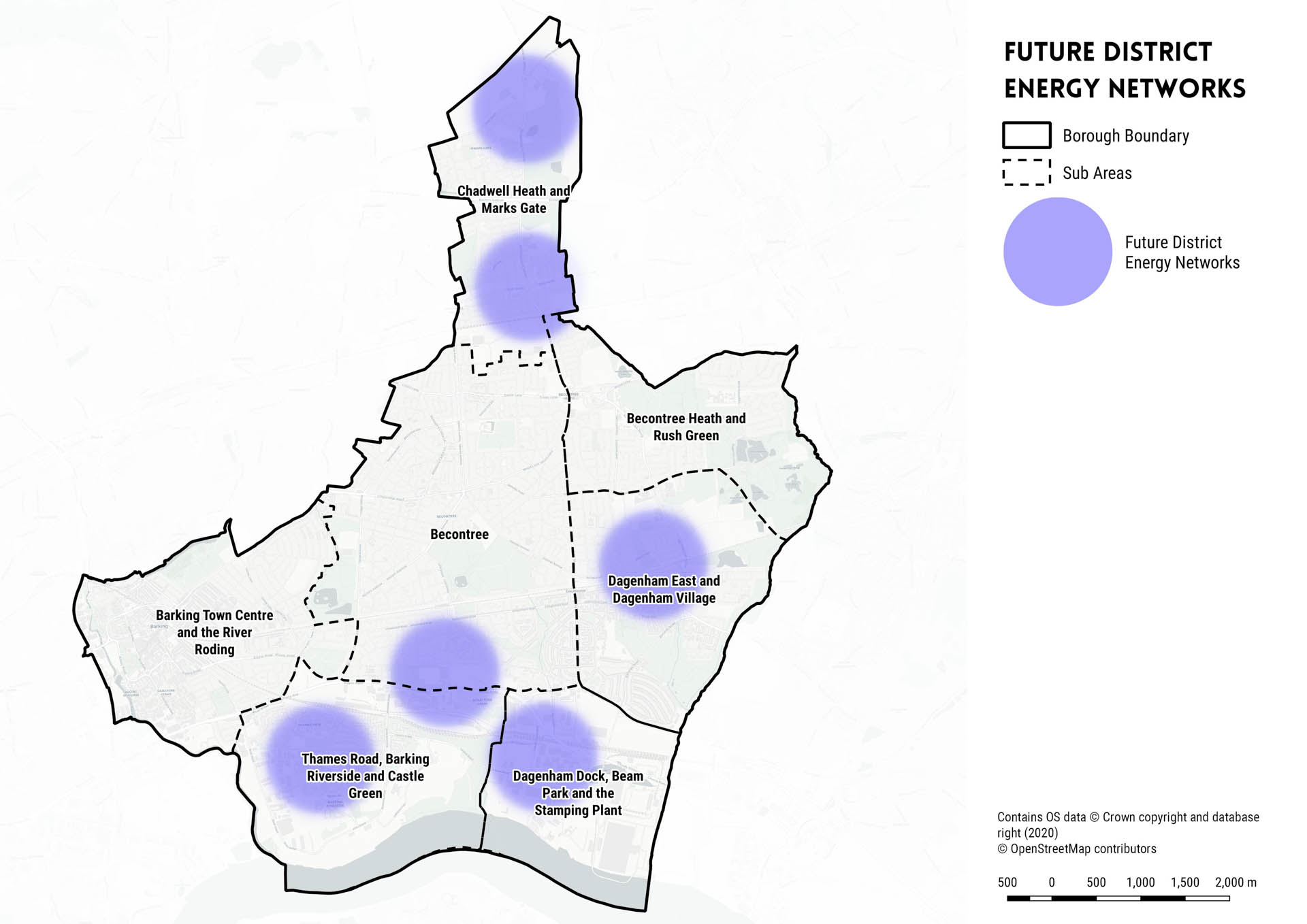
Figure 17: Proposed district energy networks in Barking and Dagenham (broad locations)
6.8 Waste
6.8.1 Waste treatment and disposal is managed by the East London Waste Authority (ELWA), as the Statutory Waste Disposal Authority for the London Boroughs of Barking and Dagenham, Havering, Newham and Redbridge. Many of the services for which ELWA is responsible are delivered by Renewi, the operator of the Integrated Waste Management Services (IWMS) Private Finance Initiative (PFI) contract.
6.8.2 The East London Joint Waste Management Strategy 2006 is summarised in the Joint Waste Development Plan (JWDP) adopted in 2012 and part of the Borough’s development plan. It sets out the services the Council undertakes, the current capacity at which their facilities operate, and the safeguarding of their necessary facilities required to meet 2011 London Plan waste apportionments until 2021.
CURRENT PROVISION
6.8.3 The main Reuse & Recycling Centre (RRC) for Borough residents is Frizlands Lane, but Gerpins Lane (Havering), Jenkins Lane (Newham) and Chigwell Road (Redbridge) also serve required demand. These facilities are managed by Renewi on behalf of ELWA as part of the IWMS PFI contract, which is in the second half of its long term (2002-2027). Upgrades to the sites were implemented in 2003 [48].
6.8.4 Jenkins Lane RRC/Mechanical Biological Treatment (MBT) facility (Newham) and Frog Island MBT (Havering), while outside of Borough boundaries, also manage waste received by the Borough. The Ilford Recycling Centre (Redbridge) receives material collected by Renewi from the Borough’s public recycling bank network. Overall, around 200,000 tonnes of total waste are converted into Refuse-Derived Fuel (RDF) which is then exported to the EU by Renewi.
6.8.5 There are additional waste transfer facilities located in and around Barking and Dagenham that are managed by private businesses.
INFRASTRUCTURE PLANNING CONSIDERATION
6.8.6 The boroughs of Barking & Dagenham, Havering, Newham and Redbridge are aiming to launch a review necessary to update the existing Joint Waste Development Plan. This is a land use allocation plan for waste infrastructure that forms part of each council’s Local Plan – with the current version expiring in 2021. The current East London JWDP is due to be updated by 2021, once adoption of the Mayor’s draft new London Plan confirms new Borough-wide statutory waste apportionments. ELWA is only a stakeholder in this particular work but provides expertise and resources/ research support to the four planning authorities.
6.8.7 The Joint Waste Development Plan will allocate land to be reserved/ allocated for waste infrastructure, which could be developed by either the public or private sector. However, this document will not directly lead to development actually taking place, nor prevent other suitable sites being brought brought forward for the development of waste infrastructure.
6.8.8 Separately, ELWA’s four constituent councils are developing an East London Joint Resources and Wastes Strategy (ELJRWS). This is a new joint municipal waste strategy setting out approaches to waste reduction, reuse, recycling and treatment/disposal for household and commercial wastes from the four constituent councils of ELWA, as well as waste deposited directly at Reuse and Recycling Centres. The ELJRWS covers the period of 2027-2057; however, action plans for periods prior to these dates will arise from the work. The Strategy is intended to be delivered
in three stages. The first stage involves the forecasting and modelling of baseline infrastructure capacities and scenario-planning, to assess waste costs, performance and carbon emissions. The scenario-forecasting exercise will take account of a range of socio-economic influences (including consumer behaviours) which affect waste infrastructure demands within the area. The ELJRWS’s forecasting will be set out in 2 strands: kerb-side and flats – the latter being an emerging focus for the ELWA and waste planners alike. Stage 2 of the Strategy will provide an appraisal of existing waste technologies; Stage 3 will assess future technological and infrastructural requirements within the four boroughs covered by the ELWA.
6.8.9 The ELJRWS will ultimately include an infrastructure strategy for ELWA and the four Constituent Councils, covering the provision of waste transfer, sorting and treatment services for the managing of the wastes presented to them. Adoption is projected for late 2022 onwards, with a consultation likely to be held in 2023.
6.8.10 The ELWA highlights that the 2022 ELJRWS will apply joined-up thinking and will consider contemporary theories to waste infrastructure planning. Barking and Dagenham is regarded as a good strategic location – with direct access to the Thames and the existing rail network, offering a multitude of opportunities for transferring waste to plants both London- wide and further afield. A number of key options are currently being evaluated by ELWA, including the implementation of new transfer stations both within and outside the Borough and the consideration of alternative, less car-dependent transfer modes such as rail and river.
6.8.11 The 2022 Strategy will also have due regard to themes such as the circular economy package, as well as repair and re-use schemes and emerging market trends. With the level of housing growth density envisioned across the Borough, there is also an identified requirement for innovative thinking in regard to the waste management needs of tall apartment buildings by the London Waste and Recycling Board, alongside a working group of partners, to help meet waste and recycling targets49. A report detailing waste management planning advice for flatted properties, waste management case studies and a template waste management strategy for developers proposing medium to high density housing has been produced.
6.8.12 With regard to planned developments in the Borough, considerable efforts will be required to ensure the waste requirements for the City of London’s new wholesale market at Barking Reach have been addressed and adequately planned-for.
6.8.13 Information on future infrastructure requirements will be made available when the ELJRWS is published in late 2022, although this date is subject to change. Further information regarding the future finance arrangements of the ELWA will be made public in 2027.
6.9 Wholesale Markets
6.9.1 Policy 2.17 (Strategic Industrial Locations) of the adopted London Plan asserts that “the Mayor will, and boroughs and other stakeholders should, promote, manage and, where appropriate, protect the strategic industrial locations (SILs) […], as London’s main reservoirs of industrial and related capacity, including general and light industrial uses, logistics, waste management and environmental industries (such as renewable energy generation), utilities, wholesale markets and some transport functions.”
6.9.2 Policy E4 of the Intend to Publish London Plan addresses the need to provide a sufficient supply of land for industry, logistics and services to support London’s economic function. Policy E4 states that “A) a sufficient supply of land and premises in different parts of London to meet current and future demands for industrial and related functions should be provided and maintained, taking into account strategic and local employment land reviews, industrial land audits and the potential for intensification, co-location and substitution. This should make provision for the varied operational requirements of […] wholesale markets”. Paragraph F) of Policy E4 further states that “efficient wholesale functions should be retained to meet London’s requirements whilst enabling opportunities to consolidate composite wholesale markets to meet long- term wholesaling needs”.
CURRENT PROVISION
6.9.3 There are five principal wholesale food and flower markets situated within London [50 – GLA (2007). Wholesale Markets Review]. These are: New Spitalfields, Smithfield, Billingsgate, New Covent Garden and New International. The City of London Corporation currently operates and manages three of these markets – Billingsgate, New Spitalfields and Smithfield. The City of London Corporation’s current role is to provide and maintain the sites and their infrastructure, as well as managing long-term leasing contracts.
INFRASTRUCTURE PLANNING CONSIDERATIONS
6.9.4 In June 2019, the City of London Corporation launched a public consultation to gauge the public’s thoughts on the proposal to consolidate and relocate the City of London’s three wholesale markets to the former Barking Reach Power Station site. As of May 2020, no planning application has been submitted for this development. However, prior approval for the demolition of Barking Reach Power Station was approved in February 2020 [51 – Planning reference: 20/00129/PRIOR4]. Jon Cruddas MP [52] states that consideration has been given to ensuring the development alleviates pressure on the A13, whilst also having due regard for sustainability and air quality impacts. As plans for this scheme continue to develop, further consideration for: transport, utilities, waste and adult learning infrastructure will be necessary.
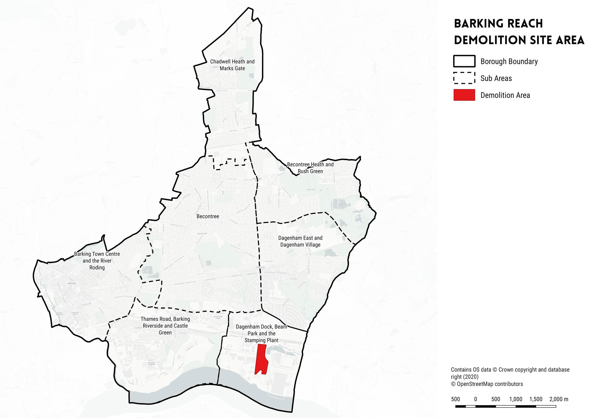
Figure 18: Barking Reach Demolition Site Area
8. GREEN INFRASTRUCTURE

Figure 32: Eastbrookend Country Park [source]
This section of the IDP presents the infrastructure requirements associated with ‘green infrastructure’ covering:
- Open space (including parks and gardens, amenity, natural and semi- natural green spaces)
- Allotments
- Burial Spaces
8.1 Planning Context
8.1.1 The revised NPPF (2019) [108] outlines the relevance of green infrastructure (GI) to the development of a Local Plan:
8.1.2 Paragraph 20 highlights that ‘Strategic policies should set out an overall strategy for the pattern, scale and quality of development, and make sufficient provision for… conservation and enhancement of the natural, built and historic environment, including landscapes and green infrastructure’.
8.1.3 Paragraph 91 requires that planning policies and decisions should aim to achieve healthy, inclusive and safe places, referencing safe and accessible green infrastructure, sports facilities and high-quality public space.
8.1.4 Paragraph 150 states that ‘New development should be planned for in ways that avoid increased vulnerability to the range of impacts arising from climate change…including through the planning of green infrastructure’.
8.1.5 Paragraph 171 states that ‘Plans should…take a strategic approach to maintaining and enhancing networks of habitats and green infrastructure’.
8.1.6 Paragraph 181 links the requirement for the identification of green infrastructure provision and enhancement at the plan making stage to the improvement of air quality or mitigation of impacts relating to this issue. The NPPF also provides a mechanism by which local authorities can protect some open spaces under a ‘Local Green Space’ designation (paras. 99 and 100).
8.1.7 The London Plan [109] and its emerging replacement contain numerous policies relating to the provision, safeguarding and management of green infrastructure. Chapter 7 (London’s Living Spaces and Places) of the adopted London Plan contains the most significant policies. In particular, Policy 7.18 states that ‘the Mayor supports the creation of new open space in London to ensure satisfactory levels of local provision to address areas of deficiency’.
8.1.8 Furthermore, open space provision should be monitored through ‘audits of all forms of open space and assessments of need’.
8.1.9 The All London Green Grid (ALGG) is a set of supplementary planning guidance (SPG) published by the Mayor in 2012 that comprises London Plan policies on green infrastructure and urban greening. Barking and Dagenham Borough falls into one of the eleven ALGG Area Frameworks: Thames Chase, Beam and Ingrebourne (Area 3 ALGG).
8.1.10 The Mayor’s Biodiversity Strategy [110] was published in 2002 as the first statutory biodiversity strategy at the regional level. The Green Infrastructure & Open Environments: Preparing Borough Tree and Woodland Strategies (February 2013) SPG [111] is a joint publication with the Forestry Commission, which gives guidance on the London Plan policies regarding trees and woodland.
8.1.11 The Mayor of London has set out requirements for the provision of private amenity space in the Housing SPG (2016) [112], which requires that a minimum of 5sqm of private outdoor space should be provided for 1-2 person dwellings and an extra 1 sqm for each additional occupant.
8.1.12 Barking and Dagenham’s Parks and Open Space Strategy (2017) [113] provides an overview of parks and open space provision and future demand in the Borough. The Strategy notes increasing demand for greenspace as a result of predicted population growth within the Borough. The Strategy includes an analysis of the distribution of regeneration areas in relation to their proximity to parks. The Parks and Open Space Strategy (2017) is one of a number of initiatives that the Council is adopting to shape the future of the Borough. The Strategy also helps to demonstrate the multiple benefits of the Borough’s parks and open spaces through local case studies.
8.1.13 Ownership and the responsibility for open space management in Barking and Dagenham rests with a broad number of public and private bodies. This includes:
- London Borough of Barking and Dagenham;
- Other public sector-owned and managed;
- Publicly owned and private sector-managed;
- Private sector-owned and managed;
- Publicly owned and voluntary sector-managed; and
- Voluntary sector-owned and managed.
8.1.14 There are a number of areas of designated Metropolitan Open Land (MOL) which are protected in accordance with the current London Plan; Policy G3 of the draft new London Plan will apply. MOL follows the principles of national green belt policy. The three areas of MOL in Barking and Dagenham are: Barking Park, Mayesbrook Park and Parsloes Park. MOL is of strategic importance as an open space resource in London.
8.1.15 There are five Local Nature Reserves in the Borough, these are: Beam Parklands; Beam Valley Country Park; Chase Nature Reserve; Eastbrookend Country Park; Ripple Nature Reserve; Scrattons Farm Ecopark; and St Peter and St Paul’s Churchyard. There are no Sites of Special Scientific Interest (SSSI) in the Borough. The Borough has 13 Sites of Importance for Nature Conservation (SINCs). The majority of these designated sites fall within parks or natural green spaces.
8.1.16 The Parks and Open Space Strategy (2017) highlights that there are deficiencies of greenspace throughout the Borough; in particular, in wards such as Beacontree and Whalebone where there are no parks. By contrast, in Eastbrook Ward there is a considerable level of green space.
8.1.17 The Borough’s Green Infrastructure and Biodiversity Strategy [114] was published in 2019. The Strategy provides a baseline review of the Borough’s environmental assets, in addition to setting a number of design principles which will help to define Barking and Dagenham’s current and future ecological and environmental networks.
8.2 Open Spaces – Parks and Gardens, Amenity, Natural and Semi-Natural Green Spaces
CURRENT PROVISION
8.2.1 The Council’s Parks and Open Spaces Strategy (2017) [115] highlights that over 13% of the Borough’s surface area is made up of parks and greenspace.
8.2.2 The Borough currently has a portfolio of 28 parks and open spaces, providing 463 hectares (ha) of public open space with a concentration in a central belt from Barking Town Centre eastwards towards Central Park and Eastbrookend Country Park. Across the entire portfolio, more parks across the Borough score poorly in relation to their overall quality (42% scored ‘averagely’ in 2003, compared to just 36% in 2017). Parks tend to score worst in terms of management and health and catering for people with disabilities. With reference to the GLA’s 2011 Public Open Space categorisations, Tables 26 and 27 below highlight the future requirements for open space up to 2026, as well as the typology and size of Barking and Dagenham’s 28 existing parks and public open spaces.
8.2.3 The Strategy outlines that current and future standards of provision in the north of the Borough are comparable with Borough-wide figures; those for the east are considerably higher, whilst standards for the west fall short of the Borough average.
8.2.4 Transport corridors such as the A13 road corridor, mainline rail services and London Underground cause accessibility barriers between local neighbourhoods and open spaces. In addition, the Parks and Open Spaces Strategy (2017) acknowledges that UK parks are facing significant funding cuts, and that it is vital that the Council continues to recognise the important health and environmental benefits of preserving and enhancing its parks and open spaces.
|
2017 |
2026 |
|
| Population Projection |
209,149 |
236,329 |
| Current ha of open space |
463.2 |
N/A |
| Future ha of open space |
N/A |
548.7 |
| Area required for 2.80Ha/1,000 HOP |
585.6 |
661.7 |
| Additional ha required to meet 2.80 Ha Standard |
122.4 |
113.1 |
| Area required for 2.4ha/1,000 HOP |
502.0 |
567.2 |
| Additional ha required to meet 2.40 ha Standard |
38.8 |
18.5 |
Table 26: Borough-wide demand for open spaces up to 2026 (LBBD Parks and Open Space Strategy, 2017)
INFRASTRUCTURE PLANNING CONSIDERATIONS
8.2.5 It is estimated that the Council’s planned regeneration programme estimates that over 71ha of public space will be delivered up to 2037 (i.e the Local Plan period) at Barking Riverside, Castle Green and Chadwell Heath [116 – *reference to Creekmouth allocation has been omitted from the July 2020 housing trajectory and is therefore the reference to this site is not included in the IDP]. These figures are based on the assumption that 20% of a regeneration area will become greenspace, in line with planned green space provision for Barking Riverside. Table 28 outlines future greenspace requirements for allocation sites and potential S106 revenue from each development, based on Barking Riverside S106 allocations (£140,000/ Ha). Table 29 sets out greenspace requirements and associated potential S106 revenues by sub-area. It is important to note that this is in line with assumptions included within the Borough’s emerging Local Plan (2.4Ha per 1,000 head of population), the Council’s housing trajectory (July 2020 version) and S106 sums generated at Barking Riverside. These figures may therefore change as development schemes evolve.
8.2.6 At present, greenspace provision equates to 2.64ha per 1,000 head of population. Taking into account future population growth, by 2027 this figure will have reduced to just 2.38ha per 1,000 head of population – which sits below the emerging Local Plan’s open space provision requirement of 2.4ha per 1,000 head population in the Borough.
8.2.7 Open space provision across all types of green space, (parks, playgrounds, sports sites, natural and semi-natural greenspaces) is 888.76ha (approximately 25% of the area of the Borough). The Parks and Open Space Study (2017) states that, due to a growing population, the Borough can no longer provide enough open space in accordance with existing Local Plan (2010) standard requirements (2.8ha per 1,000 head of population). The Study compares currently adopted standard requirements against the National Playing Fields Association Six Acre Standard (2.4ha per 1,000 head of population), which has subsequently been adopted in the emerging Local Plan.
8.2.8 The Parks and Open Space Strategy also includes a set of ten masterplans for the Borough’s parks to provide a template for future development up to 2027. Feasibility studies were undertaken for each masterplan proposal. Details of each of these masterplan proposals is provided in Chapter 9.
8.2.9 As stated in the 2017 Parks and Open Space Study, the London Borough of Barking and Dagenham has a number of mechanisms that can be used to secure funding for the improvement of existing open spaces and the creation of new open space in areas of deficiency. The Heritage Lottery Fund (HLF) and Parklife are the most important contributors to funding for parks’ investment projects.
8.2.10 The Council uses CIL to help fund open space projects as a form of infrastructure. It is noted that all three of the projects that were allocated CIL in 2018 were for parks. Similarly, the Council also uses s106 planning obligations to offset negative impacts of development and ensure sufficient access to high quality public open space for occupants of future schemes.
8.2.11 Table 30 outlines the possible funding streams for proposed parks and open spaces within the Borough over the Parks and Open Space Strategy’s 10-Year Plan period up to 2027.
8.2.12 Emerging Local Plan Policy DMNE1 (Parks, Open Spaces and Play Spaces) states that the Council will ‘will protect and enhance the Borough’s parks, public open spaces and playing pitches, working closely with a range of stakeholders to address deficiencies in quantity, quality and access.’. In addition, Policy SP6 (Green and Blue Infrastructure) states that proposals should ‘maximise opportunities to create and increase publicly accessible open space (including playing pitches and ancillary sporting facilities) with a range of sizes and for a range of users, particularly in locations which experience the highest level of open space deficiency within the Borough’.

Figure 33: Public parks and gardens in Barking and Dagenham
| Name | Typology | Size (ha) |
| Abbey Green – Abbey Ruins | Local |
6.27 |
| Barking Park | District |
29.80 |
| Beam Parklands | District |
38.75 |
| Beam Valley Country Park | District |
26.99 |
| Castle Green Park | Local |
10.41 |
| Central Park | District |
50.17 |
| Chase Nature Reserve | District |
42.22 |
| Eastbrookend Country Park | District |
55.45 |
| Essex Road Gardens | Small OS |
0.74 |
| Goresbrook Park | Local |
14.71 |
| Greatfields Park | Local |
5.80 |
| Heath Park Open Space | Small OS |
1.23 |
| Mavesbrook Park | District |
48.95 |
| Newlands Park | Small OS |
0.79 |
| Old Dagenham Park | Local |
13.38 |
| Padnall Open Space | Small OS |
1.44 |
| Parsloes Park | District |
59.57 |
| Pondfield Park | Local |
5.68 |
| Ripple Nature Reserve | Local |
7.23 |
| Scrattons Farm Ecopark | Local |
3.77 |
| St Chads Park | Local |
14.44 |
| St Peter and St Paul’s Churchyard | Small OS |
0.87 |
| Tantony Green | Small OS |
1.64 |
| The Leys | Local |
7.54 |
| Valence Park | Local |
12.20 |
| Quaker Burial Ground | Small OS |
1.69 |
| Kingston Hill Recreation Ground | Small OS |
0.56 |
| King George’s Fields | Small OS |
0.90 |
| TOTAL: |
463.19 |
Table 27: Existing parks and open spaces in Barking and Dagenham
| Allocation Site | Areas of Parks and Gardens Required (ha) | Total Estimated Value (accrued through S106) |
| Barking Riverside |
51.5 |
£7,154,000 |
| Castle Green |
13.5 |
£1,890,000 |
| Chadwell Heath (Industrial Estate) |
6.5 |
£910,000 |
| TOTAL: |
71.5 |
£9,954,000 |
Table 28: Open space requirements for proposed allocation sites within the Borough, based on a 20% overall greenspace assumption (LBBD Parks and Open Space Strategy, 2017)
| Sub-Area | Total open space requirement (based on emerging Local Plan requirements up to 2037) | Estimated S106 revenue allocated to open space provision over Plan period |
| Barking Town Centre and the River Roding |
83.76ha |
£11,726,000 |
| Becontree |
7.65ha |
£1,071,000 |
| Becontree Heath and Rush Green |
3.10ha |
£434,000 |
| Dagenham Dock, Beam Park and the Stamping Plant |
34.86ha |
£4,880,400 |
| Thames Road, Barking Riverside and Castle Green |
72.70ha |
£10,178,000 |
| Dagenham East and Dagenham Village |
6.72ha |
£940,800 |
| Chadwell Heath and Marks Gate |
21.35ha |
£2,989,000 |
Table 29: Open space requirement by sub-area
| External Sources: | Total Paid by External Sources (£): | Internal Sources (£): | Overall Total (£): |
| Heritage Lottery Fund |
3,143,700 |
540,127 |
3,683,827 |
| Sport England |
1,000,000 |
165,000 |
1,165,000 |
| Sport governing bodies |
500,000 |
82,500 |
582,500 |
| London Marathon Trust |
200,000 |
50,000 |
250,000 |
| Landfill Communities Scheme |
200,000 |
50,000 |
250,000 |
| Parklife partners |
3,000,000 |
400,000 |
3,400,000 |
| S106/CIL | – |
1,000,000 |
1,000,000 |
| TOTAL |
£10,331,327 |
Table 30: Funding mechanisms for planned open space provision in the Borough
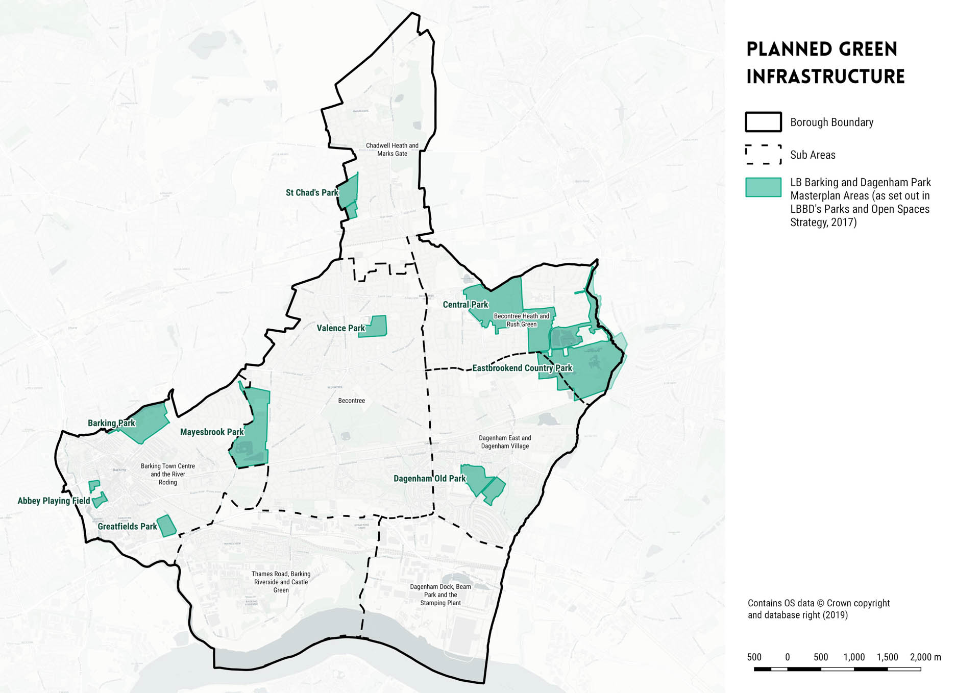
Figure 34: Proposed park improvement masterplan areas in Barking and Dagenham
8.3 Allotments
8.3.1 The IDP grouping of allotments includes allotments, community gardens and city farms. Growing food in parks has become more commonplace within the Borough over the past decade.
8.3.2 Policy 7.22 (Land for Food) of the current London Plan (2016) [117] supports the continued use of allotments, by stating that‘ […] Boroughs should protect existing allotments. They should identify other potential spaces that could be used for commercial food production or for community gardening, including for allotments and orchard’. Policy G8 of the draft new London Plan (2018) [118] also states that the Borough should ‘protect existing allotments and encourage provision of space for community gardening, including for food growing, within new developments or as a meanwhile use on vacant or under-utilised sites’.
8.3.3 The Emerging Local Plan (2019) Policy DMNE6 (Local Food Growing Including Allotments) reaffirms the stance taken by the current London Plan (2016), by outlining that ‘redevelopment of existing allotments will only be permitted in exceptional circumstances where it can be demonstrated that they are no longer needed by the community and existing allotment users are relocated to an alternative allotment that is within reasonable proximity to their homes’. Policy DMNE6 also states that ‘proposals for new allotments will be supported where there is a demonstrable local need through appropriate engagement with key stakeholders and the local community, and where this does not prejudice alternative land uses from coming forward, including residential use.’
8.3.4 Barking and Dagenham’s Parks and Open Space Strategy (2017) [119] states that the Borough has supported the principle of food growing as part of the Capital Growth campaign, through policy and through developing practical projects for several years.
CURRENT PROVISION
8.3.5 As is the case with most other London boroughs, the demand for allotments has grown within Barking and Dagenham. There are currently 20 active food growing projects that have been initiated in schools, care homes, housing estates and communal areas within the Borough . Of these, nearly all of the allotment sites operate a waiting list which the Council has made efforts to reduce. The Council has also created some new sites, whilst re-locating others (all of which are now independently managed).
8.3.6 There are 13 allotments within the Borough. These are shown in Table 31. Most of the allotments listed above have some form of restricted access, to enable volunteers to benefit from the harvest. In addition, the Borough has a further 16 food growing spaces, including: 1 far; 1 activity centre; 1 prescription garden; 1 community allotment; 1 children’s centre; 1 community garden; 9 school gardens/gardening clubs; and 1 victory garden.
8.3.7 The spatial distribution of allotment provision is uneven, with a lack of food growing and allotment space in the south of the Borough, with deficiencies primarily concentrated in Creekmouth and Barking Reach.
8.3.8 The key resource opportunities for food growing initiatives within the Borough are:
- Voluntary-led
- Council-led schemes
- Community and social enterprise
- London-wide initiatives
INFRASTRUCTURE PLANNING CONSIDERATIONS
8.3.9 The Council has no standard requirement for the provision of allotment space per 1,000 head of the population. Therefore, given the predicted population growth for the Borough over the emerging Plan period, it is likely that there will be an increase in demand for food growing spaces. However, the exact number of additional allotment plots required is currently unknown.
8.3.10 The Parks and Open Spaces Strategy (2017) recommends that there are further opportunities to expand the Central Park and Growing Communities Dagenham Farm, in addition to plans for new orchards (associated with St Chads and Barking Park) and the incorporation of herb beds at Eastbrook End Country Park. A key priority for the Council is to develop a new growing area at Old Dagenham Park and Barking Park Pavilion.
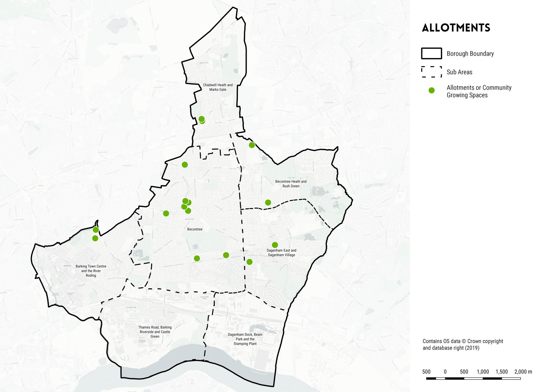
Figure 35: Allotments in Barking and Dagenham
8.4 Cemeteries
8.4.1 Policy SP4 (Delivering Social and Cultural Infrastructure Facilities in the Right Locations) states that ‘the Council will seek to ensure that a range of high quality social and cultural infrastructure facilities for existing and new residents and workers are provided in appropriate locations throughout the Borough’.
8.4.2 In addition, Policy S7 (Burial Space) of the draft new London Plan (2018) states that ‘cemeteries should be protected, and the re-use of burial space supported’.
CURRENT PROVISION
8.4.3 There is currently a shortage of burial spaces within the Borough. In 2018, only one of the three existing cemeteries had space for new burials.
8.4.4 There are currently three burial grounds in Barking and Dagenham, including: Rippleside, Eastbrookend and Chadwell Heath [120 – An Audit of London Burial Provision, (2011), Julie Rugg and Nicolas Please].
8.4.5 All burial grounds within the Borough are council owned. Rippleside, the largest and oldest cemetery within the Borough, is the only cemetery with a Muslim faith section.
| Name | Date | Area (ha) | Owner | Capacity |
| Rippleside |
1886 |
12.7 |
LBBD | Re-open only |
| Eastbrookend |
1914 |
4.5 |
LBBD | N/A |
| Chadwell Heath |
1934 |
8.0 |
LBBD | Closed |
Table 32: Burial space capacity within the Borough
INFRASTRUCTURE PLANNING CONSIDERATIONS
8.4.6 In 2016, the Borough invested £400,000 into the Chadwell Heath Cemetery expansion . The development proposal stated that 500 additional burial spaces would be provided, with 10% of these spaces being allocated for Muslim burials [121]. In addition, a new landscaped columbarium would provide space for people to store cremated remains. The new development will also include a designated pet cemetery.
8.4.7 To address Barking and Dagenham’s needs, it is possible that the surplus of burial spaces in the neighbouring borough of Redbridge may be able to part-meet Barking and Redbridge’s underlying need. In 2011, Redbridge had an additional capacity of 13,800 burial spaces available, of which 13,000 spaces are available at Forest Park. It has been noted that Forest Park Cemetery could use existing virgin-land to extend the site further.
8.4.8 There are currently no plans to expand the Rippleside or Eastbrookend sites, nor are there any proposals to develop a new burial ground within the Borough. Future burial space provision requirements are therefore not known at this time.
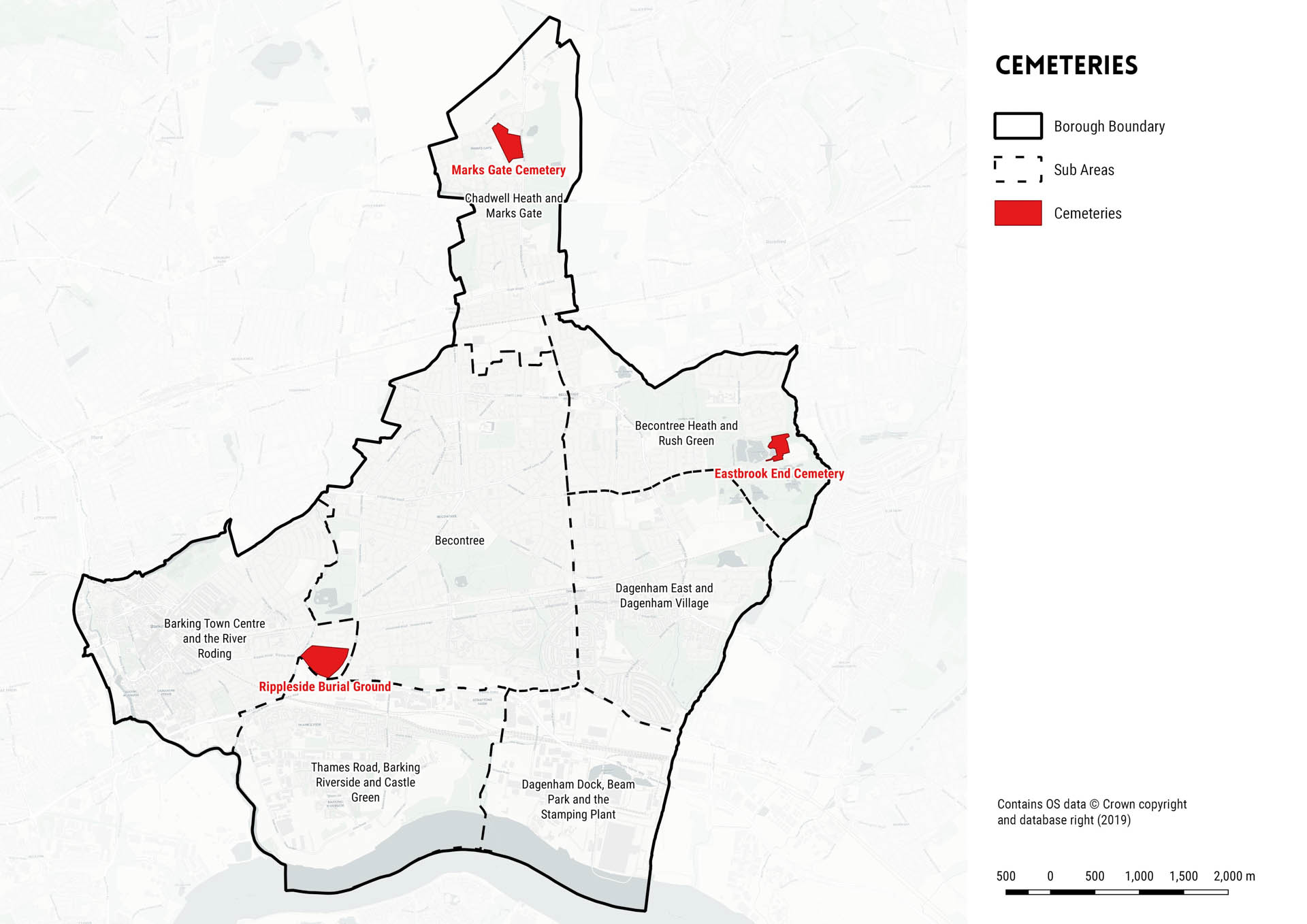
Figure 36: Cemeteries in Barking and Dagenham
9. SUB-AREA ANALYSIS
This section of the IDP provides a summary of the following for each of the Borough’s seven sub-areas:
- Proposed housing and employment growth (based on the emerging Local Plan)
- Current infrastructure
- Proposed infrastructure (covering the Plan period and beyond the Plan period)
- Borough-wide proposed infrastructure

Figure 37: Sites allocated for housing and employment in the emerging Local Plan (based on the July 2020 housing trajectory and November 2019 employment trajectory)
9.1 Sub-Area Analysis
9.1.1 In order to simplify the assessment of the infrastructure needs of the Borough, a thematic approach has been adopted which categorises the types of infrastructure, as set out in the previous chapters of this report.
INFORMATION SOURCES
9.1.2 Proposed infrastructure projects/requirements were identified through a number of sources. Sources include:
- Adopted Plans and Strategies;
- Service provider engagement (including internal service provider workshops, external meetings, Duty to Cooperate meetings, follow- up conversations);
- Submitted planning applications and associated documentation (this is only the case where we were made aware of major infrastructure plans by Plans, service providers or the Council).
- Developer engagement (completion of our developer survey).
9.1.3 In all cases, the main sources of information have been referenced within this Chapter.
INFRASTRUCTURE TABLE INFORMATION SUMMARY
9.1.4 For each proposed infrastructure project/requirement, information has been recorded for each of the following headings:
- Estimated overall cost
- Funding source(s)
- Identified secured funding
- Funding gap
- Project timescales
- Lead organisation(s)
- Category (critical, necessary or important)
- Status (in development, planned or identified need figure only)
- Associated Local Plan policies
- Source(s)
9.1.5 Where information is missing, missing gaps have been recorded as ‘unknown’. It is considered that further information is likely to come forward as plans develop.
PROJECT TIMESCALES
9.1.6 To align with the emerging Plan period (2019-2036/37), the IDP has divided project timescales into the following phases:
- Phase A (2019-2023/24)
- Phase B (2025-2028/29)
- Phase C (2030-2036/37)
CATEGORISING INFRASTRUCTURE
9.1.7 The IDP assesses infrastructure requirements and needs and assigns each project/requirement a priority based on whether the provision
is critical, important and desirable. For the purposes of the IDP, the definitions which apply to the prioritisation of infrastructure are summarised in Table 33. It is important to note that infrastructure project prioritisation (phasing) is not reflective of its associated categorisation. For more information on the prioritisation of infrastructure projects, please see the ‘Project/Requirement Status’ section below.
ASSOCIATED LOCAL PLAN POLICIES
9.1.8 This Chapter includes emerging Local Plan policies which are relevant to each specific project/requirement.
PROJECT / REQUIREMENT STATUS
9.1.9 Projects/requirements outlined in the sub-area analysis have been assigned a status based on the latest information relating to the current delivery and progress of each project/requirement. Definitions which apply to the status of infrastructure are highlighted in Table 34.
9.1.10 As highlighted in Figure 38, the status of each infrastructure project/ requirement in part reflects its delivery stage. Put simply, it is likely that those projects/requirements that are in development are likely to be delivered before those with an ‘identified need’ status, as, those ‘in development’ have already progressed through the planning process. Please note, this is a generalised approach which reflects a snapshot of project/requirements made during the time of writing. In some cases, emphasis on ‘identified need’ projects/requirements may change over the Plan period and therefore some projects/requirements may become prioritised over others. In essence, it is critical that balance is achieved to ensure that infrastructure provision can fully support the existing and new community. The ability to strike this balance will, in turn, affect the speed of build-out rates of developments.
| Category | Definition |
| Critical | Delivery of the identified infrastructure is critical and without which
development cannot commence |
| Necessary | The identified infrastructure is necessary to support new development, but the precise timing and phasing is less critical, and development may be able to commence ahead of its provision. |
| Important | Delivery of the identified infrastructure is important in order to help build sustainable communities, but timing and phasing is not critical over the Plan period |
Table 33: Categorisation of infrastructure types
| Status | Definition |
| In Development | Projects/requirements which have been granted planning permission and are currently being developed |
| Planned | Projects/requirements outlined within adopted Plans and Strategies which are to be delivered during the Plan period |
| Identified Need | This applies to infrastructure requirements which have been outlined by internal and external service providers. In each case, the responsible service provider has taken a modelled approach to make assumptions on infrastructure needs, based on the emerging Local Plan’s housing and employment figures. |
Table 34: Status of infrastructure types

Figure 38: Status of infrastructure project/requirement
9.2 BARKING TOWN CENTRE AND THE RIVER RODING AREA
| KEY FIGURES | |
| Current population (ONS Mid-18 Estimate Range): | 48,983 – 52,465 |
| Number of homes allocated throughout the Plan period (2019-2037)
(based on July 2020 housing trajectory): |
Approx. 15,198 units |
| Number of homes allocated beyond the Plan period (2037+ (based on July 2020 housing trajectory)): | Approx. 66 units |
| Total employment development area: | To be confirmed |
| Flood Zone: | 2 and 3 |
| Estimated population increase during Plan period (based on July 2020 housing trajectory): | 34,995 persons |
| Estimated population increase beyond Plan period (based on July 2020 housing trajectory): | 152 persons |
|
Major development sites: |
Barking Station, Gascoigne Estate East, Harts Lane Estate, Abbey Retail Park, Gascoigne Industrial Area, Freshwharf Estate, Vicarage Field |
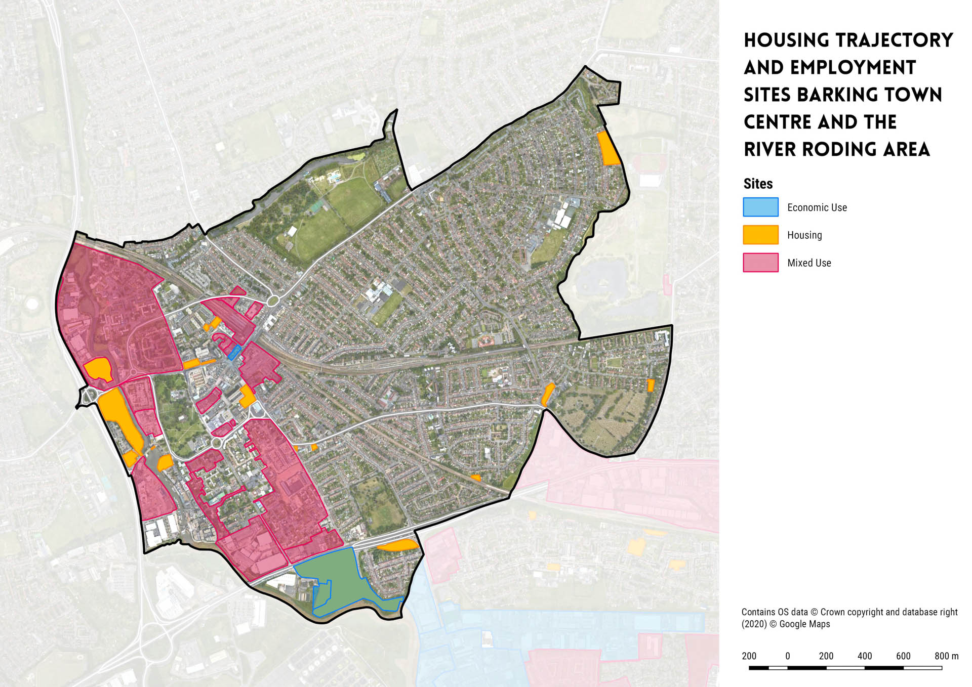
Figure 39: Barking Town Centre and the River Roding housing and employment site allocations (based on the July 2020 housing trajectory and the November 2019 employment trajectory)
CURRENT INFRASTRUCTURE IN BARKING TOWN CENTRE AND THE RIVER RODING AREA
| Infrastructure Type | Current infrastructure within sub-area (all) |
| PHYSICAL INFRASTRUCTURE | |
| Flood Defences | Raised defence (man-made) along the River Roding and River Thames, Barking Creek barrier, secondary tidal defences on River Roding numerour minor defences structures along Mayes Brook (fluvial flood storage), Ship and Shovel Relief Sewer and Loxford Water |
| Water Supply | Essex and Suffolk Water estimate good supply borough-wide up to 2060 |
| Transport – Road Network | Principal road network:
|
| Transport – Rail Network |
|
| Transport – Bus | Main bus routes: 5, 62, 169, 238, 287, 366, 368, 687, EL1, EL2, EL3, NI5, |
| Transport – Walking & Cycling | Cycle routes:
|
| Electricity | 275kV power line running along western boundary of sub-area (National Grid) |
| Gas | Unknown |
| Telecomms. and Internet | 2 – 93 Mbit/s broadband download speed range in sub-area |
| District Energy Heating | Barking Town Centre network – supplied to Gascoigne East (Phase 1 – 381 dwellings) in March 2018 |
| Waste | Jenkins Lane Reuse and Recycling Centre (>1km away in LB Newham) |
| SOCIAL INFRASTRUCTURE | |
| Early Years and Childcare Provision | Abbey Children’s Centre Day Nursery, Playaway at BLC, Barney Bears, Royal Gate Kids Pre School, Childville Pre School at Gascoigne, Chesnut at the Gascoigne, Arden House & The Maples,Westbury Day Nursery, Eastbury CC Nurs., Play & Learn Barking, Orange and Lemon, Playland, Spinduliukus, Calvary Greatfields Nursery |
| Primary Schools | Manor Infant School, Manor Junior School, Eastbury Community School, Eastbury Primary School, Ripple Primary School, Gascoigne Primary School, St Joseph’s Catholic Primary School, St Margaret’s C of E Primary School, Northbury Primary School |
| Secondary Schools | Barking Abbey School, Eastbury Community School, Greatfields School |
| SEN | No facilities within the sub-area |
| Further Education | Provided in existing secondary schools |
| Adult Learning | Adult College of Barking and Dagenham |
| Healthcare | John Smiths Medical Centre (GP), Highgrove Surgey (GP), Gupta Dr & Partners Surgery (GP), Abbey Medical Centre (GP), Dr N Niranjan (GP), NHS The Child & Family Centre (GP), Dr John’s Surgery (GP), Shifa Medical Practice (GP), The Barking Medical Group Practice (GP), Barking Community Hospital, Ripple Road Medical Centre (Branch Surgery), Dr Ansari Movers Lane Surgery (Branch Surgery) |
| Police | Barking Police Centre |
| Fire and Rescue Service | Barking Fire Station |
| Ambulance Service | No facilities within the sub-area |
| Arts and Cultural Facilities | Ice House Court (artist workspace), A House for Artists (live in artist workspaces), Broadway Theatre (dance and music venue), The Victoria (music venue), Simplicity Records Ltd. and Nasha Records Ltd. (music office-based businesses), Bow Arts ( live in artist workspace and creative workspace), Studio 3 (creative workspace), Deuce Lounge, Kings Lounge, Victoria, Barking Dog, Boathouse Cafe and Bar, IBIS Hotel (Cafe Riviera), Jolly Fisherman, Spotted Dog and the Royal Oak (pubs) |
| Community Centres | Hedgecock Community Centre, Eastbury Manor House, Ripple Centre, Barking Learning Centre, Abbey Community Hall, Gascoigne Community Centre, Galleon Community Centre |
| Libraries | No facilities within the sub-area |
| Children’s Play and Youth Facilities | 12 outdoor play spaces (see play spaces map for localities) |
| Indoor & Outdoor Sports | Abbey Leisure Centre, Barking & District Indoor Bowls, Barking Abbey School (Long Birdge Campus & Leisure Centre), Barking Park, Eastbury Community School, Eastbury Primary School, Greatfields Park, St Margarets C of E Primary School, The Gym |
| GREEN INFRASTRUCTURE | |
| Parks and Open Spaces | Barking Park, Abbey Playing Field, Greatfields Park, Abbey Green Park |
| Allotments | Barking Park Allotments |
| Burial Ground | Rippleside Burial Ground |
PLANNED INFRASTRUCTURE IN BARKING TOWN CENTRE AND THE RIVER RODING AREA
9.3 THAMES ROAD, BARKING RIVERSIDE AND CASTLE GREEN
| KEY FIGURES | |
| Current population (ONS Mid-18 Estimate Range): | 13,586 – 14,141 |
| Number of homes allocated throughout the Plan period (2019-2037)
(based on July 2020 housing trajectory): |
Approx. 13,170 units |
| Number of homes allocated beyond the Plan period (2037+ (based on July 2020 housing trajectory)): | Approx. 11,250 units |
| Total employment development area: | To be confirmed |
| Flood Zone: | 2 and 3 |
| Estimated population increase during Plan period (based on July 2020 housing trajectory): | 30,291 persons |
| Estimated population increase beyond Plan period (based on July 2020 housing trajectory): | 25,875 persons |
|
Major development sites: |
Barking Riverside, Rippleside (Castle Green), Thames Road |
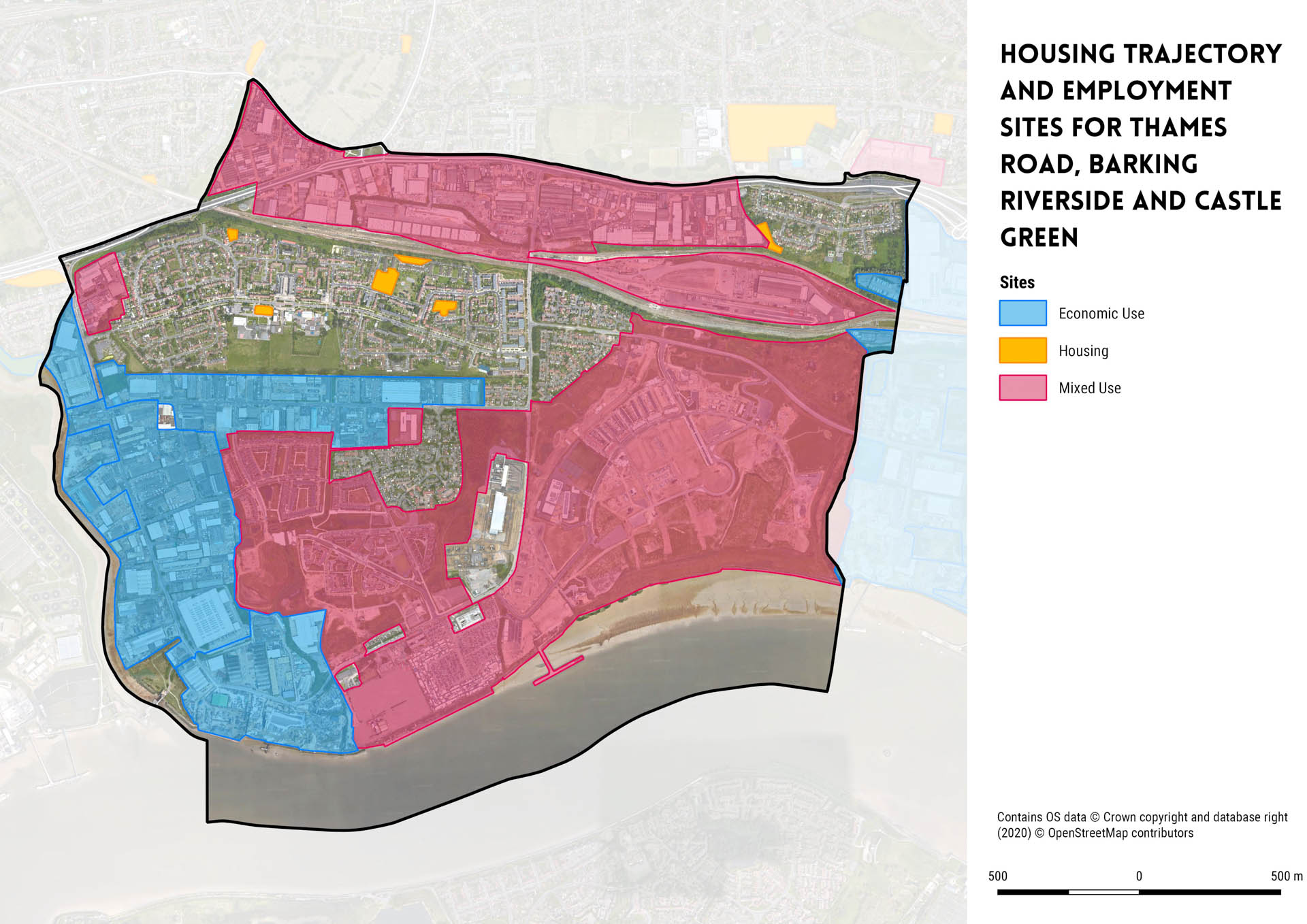
Figure 40: Thames Road, Barking Riverside and Castle Green housing and employment site allocations (based on the July 2020 housing trajectory and the November 2019 employment trajectory)
CURRENT INFRASTRUCTURE IN THAMES ROAD, BARKING RIVERSIDE AND CASTLE GREEN AREA
| Infrastructure Type | Current Infrastructure within sub-area (all) |
| PHYSICAL INFRASTRUCTURE | |
| Flood Defences | Raised defence (man-made) along the River Roding and River Thames, Barking Creek barrier, secondary tidal defences on River Roding, numerour minor defences structures along the Ship and Shovel Relief Sewer |
| Water Supply | Essex and Suffolk Water estimate good supply borough-wide up to 2060 |
| Transport – Rail Network | No stations within sub-area |
| Transport – Bus | Main bus routes: EL1, EL2, EL3, 173, 287 |
| Transport – Walking and Cycling | Cycle routes: Cycle Superhighway 3 (parallel to A13) |
| Transport – River | No existing river passenger services |
| Electricity | 400 kV and 275kV power line (NG) east-west direction through sub-area, including some electric. assets in the vicinity of Barking Riverside |
| Gas | Unknown |
| Telecomms. and Internet | 2 – 93 Mbit/s broadband download speed range in sub-area |
| District Energy Heating | No facilities within the sub-area |
| Waste | Jenkins Lane Reuse and Recycling Centre (>1km away in LB Newham) |
| SOCIAL INFRASTRUCTURE | |
| Early Years and Childcare Provision | Sue Bramley CC Nursery, Barking Riverside, Childville at Thames View, Spectacular Kidz Day Nursery and Pre School, Kiddies Lounge Pre School and Day Nursery |
| Primary Schools | Thames View Junior School, Thames View Infant School, George Carey Church of England Primary School, Riverside School |
| Secondary Schools | Riverside School |
| Special Education Needs and Disabilities | No facilities within the sub-area |
| Further Education | Provided in existing secondary schools |
| Adult Learning | No facilities within the sub-area |
| Healthcare | Riverside Clinic (Branch Surgery), Thames View Health Centre |
| Police | Barking Police Centre |
| Fire and Rescue Service | No facilities within the sub-area |
| Ambulance Service | No facilities within the sub-area |
| Arts and Cultural Facilities | Lighterman (pub), Ship and Shovel (pub), Other Fabrications Ltd. (making & manufacturing, set & exhibit.) |
| Community Centres | Thames View Community Hall, Scrattons Social Club and Community Hall |
| Libraries | Thames View Library |
| Children’s Play and Youth Facilities | 8 outdoor play spaces (see play spaces map for localities) |
| Indoor & Outdoor Sports | Thames View Junior School, Rivergate Centre, Riverside School |
| GREEN INFRASTRUCTURE | |
| Parks and Open Spaces | Alderman Avenue Green Space, Newlands Park, Scrattons Farm Green Space |
| Allotments | No facilities within the sub-area |
| Burial Ground | No facilities within the sub-area |
PLANNED INFRASTRUCTURE IN THAMES ROAD, BARKING RIVERSIDE AND CASTLE GREEN AREA
9.4 DAGENHAM DOCK, BEAM PARK AND THE STAMPING PLANT
| KEY FIGURES | |
| Current population (ONS Mid-18 Estimate Range): | 0 – 991 |
| Number of homes allocated throughout the Plan period (2019-2037) (based on July 2020 housing trajectory): | Approx. 6,316 units |
| Number of homes allocated beyond the Plan period (2037+ (based on July 2020 housing trajectory)): | Approx. 0 units |
| Total employment development area: | To be confirmed |
| Flood Zone: | 2 and 3 |
| Estimated population increase during Plan period (based on July 2020 housing trajectory): | 14,527 persons |
| Estimated population increase beyond Plan period (based on July 2020 housing trajectory): | 0 persons |
| Major development sites: | Stamping Plant, Beam Park, GSR and Gill sites |
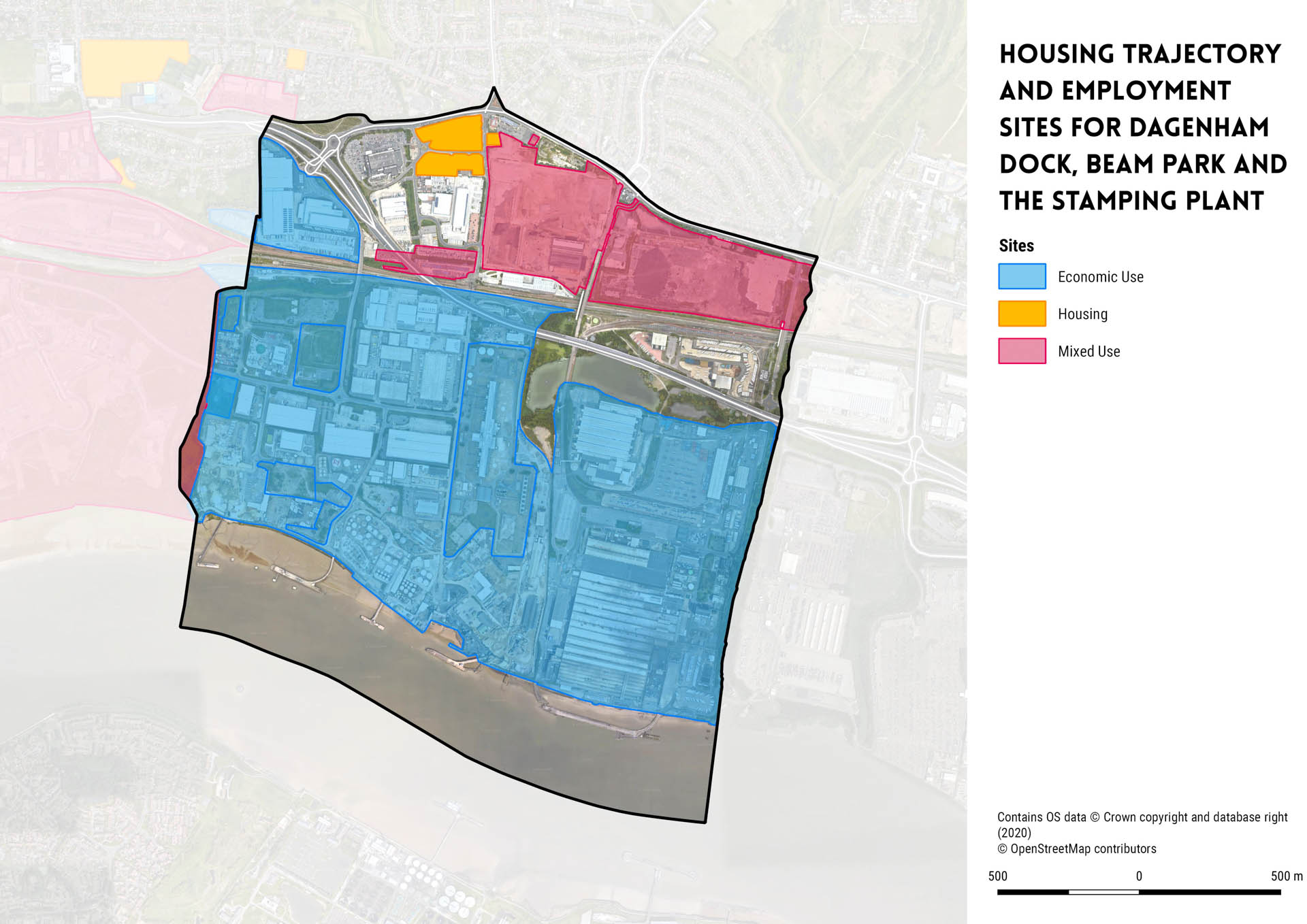
Figure 41: Dagenham Dock, Beam Park and the Stamping Plant housing and employment site allocations (based on the July 2020 housing trajectory and the November 2019 employment trajectory)
CURRENT INFRASTRUCTURE IN DAGENHAM DOCK, BEAM PARK AND THE STAMPING PLANT AREA
| Infrastructure Type | Current Infrastructure within sub-area (all) |
| PHYSICAL INFRASTRUCTURE | |
| Flood Defences | Raised defence (man-made) along the River Thames, numerour minor defences structures at Dagenham Breach, drainage system outfall and fluvial flood storage along Beam River |
| Water Supply | Essex and Suffolk Water estimate good supply borough-wide up to 2060 |
| Transport – Road Network | Principal network: A13 (Alfreds Way) |
| Transport – Rail Network | Dagenham Dock (c2c Grays via Rainham service) |
| Transport – Bus | Main bus routes: EL2 |
| Transport – Walking & Cycling | No major cycle routes within the sub-area |
| Electricity | 400 kV and 275kV power line (NG) east-west direction through sub-area |
| Gas | Unknown |
| Telecomms. and Internet | 2 – 55 Mbit/s broadband download speed range in sub-area |
| District Energy Heating | No facilities within the sub-area |
| Waste | Frizlands Lane Depot (>1km away) |
| SOCIAL INFRASTRUCTURE | |
| Early Years and Childcare Provision | No facilities within the sub-area |
| Primary Schools | No facilities within the sub-area |
| Secondary Schools | No facilities within the sub-area |
| Special Education Needs and Disabilities | No facilities within the sub-area |
| Further Education | Provided in existing secondary schools |
| Adult Learning | No facilities within the sub-area |
| Healthcare | No facilities within the sub-area |
| Police | No facilities within the sub-area |
| Fire and Rescue Service | No facilities within the sub-area |
| Ambulance Service | No facilities within the sub-area |
| Arts and Cultural Facilities | Brewers Fayre (pub) |
| Community Centres | No facilities within the sub-area |
| Libraries | No facilities within the sub-area |
| Children’s Play and Youth Facilities | 0 outdoor play spaces (see play spaces map for localities) |
| Indoor & Outdoor Sports | No facilities within the sub-area |
| GREEN INFRASTRUCTURE | |
| Parks and Open Spaces | No facilities within the sub-area |
| Allotments | No facilities within the sub-area |
| Burial Ground | No facilities within the sub-area |
PLANNED INFRASTRUCTURE IN DAGENHAM DOCK, BEAM PARK AND THE STAMPING PLANT AREA
9.5 DAGENHAM EAST AND DAGENHAM VILLAGE
| KEY FIGURES | |
| Current population (ONS Mid-18 Estimate Range): | 30,301 – 31,987 |
| Number of homes allocated throughout the Plan period (2019-2037)
(based on July 2020 housing trajectory): |
Approx. 1,217 units |
| Number of homes allocated beyond the Plan period (2037+ (based on July 2020 housing trajectory)): | Approx. 0 units |
| Total employment development area: | To be confirmed |
| Flood Zone: | 2 and 3 |
| Estimated population increase during Plan period (based on July 2020 housing trajectory): | 2,799 persons |
| Estimated population increase beyond Plan period (based on July 2020 housing trajectory): | 0 persons |
| Major development sites: | Ibscott Close Estate |

Figure 42: Dagenham East and Dagenham Village housing and employment site allocations (based on the July 2020 housing trajectory and the November 2019 employment trajectory)
CURRENT INFRASTRUCTURE IN DAGENHAM EAST AND DAGENHAM VILLAGE
| Infrastructure Type | Current Infrastructure within sub-area (all) |
| PHYSICAL INFRASTRUCTURE | |
| Flood Defences | Numerous defence structures along the Wantz Stream |
| Water Supply | Essex and Suffolk Water estimate good supply borough-wide up to 2060 |
| Transport – Rail Network | Principal Network: Rainham Road South, Church Elm Lane, Reede Road, Ballards Road |
| Transport – Bus | Dagenham East Station (Underground District Line) |
| Transport – Walking and Cycling | Main bus routes: 103, 145, 173, 174, 175, 287, |
| Transport – River | No existing major cycle routes |
| Electricity | No facilities within the sub-area |
| Gas | Unknown |
| Telecomms. and Internet | 2 – 93 Mbit/s broadband download speed range in sub-area |
| District Energy Heating | No facilities within the sub-area |
| Waste | Frizlands Lane Depot (>1km away) |
| SOCIAL INFRASTRUCTURE | |
| Early Years and Childcare Provision | Nurseries: Heritage Day, Elm Lane, Ford Road, Leys CC, Jon Perry CC, Lets Play, Childville at Dag. Parish Hall, Trinity, Leaping Toads |
| Primary Schools | Eastbrook School, Richard Alibon Primary School, Hunters Hall Primary School, William Ford Church of England Junior School, John Perry Primary School, The Leys Primary School, Marsh Green Primary School, Beam County Primary School, Village Infants’ School |
| Secondary Schools | Eastbrook School, Elutec, Dagenham Park Church of England School |
| Special Education Needs and Disabilities | No facilities within the sub-area |
| Further Education | Provided in existing secondary schools |
| Adult Learning | No facilities within the sub-area |
| Healthcare | Parkview Medical Centre (GP), The Surgery Dewey Road (GP), Church Elm Lane Health Centre (GP), The Broad Street Walk-in Centre (Hospital), Broad Street Medical Practice (GP), First Avenue Surgery (GP) |
| Police | No facilities within the sub-area |
| Fire and Rescue Service | No facilities within the sub-area |
| Ambulance Service | No facilities within the sub-area |
| Arts and Cultural Facilities | Pubs: Eastbrook, Pipe Major, Cross Keys, Admiral Vernon, Lord Denman, prop and costume-making: Londoneast UK |
| Community Centres | No facilities within the sub-area |
| Libraries | No facilities within the sub-area |
| Children’s Play and Youth Facilities | 13 outdoor play spaces (see play spaces map for localities) |
| Indoor & Outdoor Sports | Dagenham & Redbridge FC, Dagenham Park Leisure Centre, Eastbrook School, Elutec, Golds Gym, John Perry Primary School, Manor Road Sports Ground, Old Dagenham Park, Pondfield Park, The Leys, William Ford C of E Junior School |
| GREEN INFRASTRUCTURE | |
| Parks and Open Spaces | Eastbrook End Country Park, Beam Valley Country Park, Old Dagenham Park |
| Allotments | Exeter Road Allotments, Manning Road Allotment |
| Burial Ground | No facilities within the sub-area |
PLANNED INFRASTRUCTURE IN DAGENHAM EAST AND DAGENHAM VILLAGE
9.6 BECONTREE HEATH AND RUSH GREEN
| KEY FIGURES | |
| Current population (ONS Mid-18 Estimate Range): | 19,145 – 22,208 |
| Number of homes allocated throughout the Plan period (2019-2037) (based on July 2020 housing trajectory): | Approx. 561 units |
| Number of homes allocated beyond the Plan period (2037+ (based on July 2020 housing trajectory)): | Approx. 0 units |
| Total employment development area: | To be confirmed |
| Flood Zone: | 2 and 3 |
| Estimated population increase during Plan period (based on July 2020 housing trajectory): | 1,290 persons |
| Estimated population increase beyond Plan period (based on July 2020 housing trajectory): | 0 persons |
| Major development sites: | None |

Figure 43: Becontree Heath and Rush Green housing and employment site allocations (based on the July 2020 housing trajectory and the November 2019 employment trajectory)
CURRENT INFRASTRUCTURE IN BECONTREE HEATH AND RUSH GREEN AREA
| Infrastructure Type | Current Infrastructure within sub-area (all) |
| PHYSICAL INFRASTRUCTURE | |
| Flood Defences | No hard defences along the River Rom and River Beam within the sub-area |
| Water Supply | Essex and Suffolk Water estimate good supply borough-wide up to 2060 |
| Transport – Road Network | Principal network:
|
| Transport – Rail Network | No existing station within the sub-area |
| Transport – Bus | Main bus routes: 5, 103, 128, 150, 174, 175, 499, EL2, NI5 |
| Transport – Walking & Cycling | No major cycling routes |
| Electricity | No facilities within the sub-area |
| Gas | Unknown |
| Telecomms. and Internet | 2 – 93 Mbit/s broadband download speed range in sub-area |
| District Energy Heating | Becontree existing heat network (currently serving 170 dwellings and Becontree Health Leisure Centre, capacity for 50 dwell. total |
| Waste | Frizlands Lane Depot |
| SOCIAL INFRASTRUCTURE | |
| Early Years and Childcare Provision | The Ark, Beacon Pre-School, William Bellamy CC School, Kidzland Nursery, Tubbies, YMCA, Cornerstone Academy, 1st Steps, Morning Stars |
| Primary Schools | William Bellamy Primary School, Rush Green Primary School, |
| Secondary Schools | All Saints Catholic School & Technology College, Robert Clack Upper School |
| Special Education Needs and Disabilities | No facilities within the sub-area |
| Further Education | Provided in existing secondary schools |
| Adult Learning | No facilities within the sub-area |
| Healthcare | Laburnum Health Centre (GP), Rush Green Medical Centre (GP) |
| Police | No facilities within the sub-area |
| Fire and Rescue Service | Dagenham Fire Station |
| Ambulance Service | No facilities within the sub-area |
| Arts and Cultural Facilities | Three Travellers (pub and live music venue) |
| Community Centres | Heath Park Community Centre, Wantz Hall |
| Libraries | Rush Green Library, Wantz Library |
| Children’s Play and Youth Facilities | 6 outdoor play spaces (see play spaces map for localities) |
| Indoor & Outdoor Sports | May & Baker Sports & Social Club, Barking & Dagenham College, Trinity School, Becontree Health & Leisure Centre, Robert Clack School (Upper), William Bellamy Primary School, All Saints Catholic School & Technology College |
| GREEN INFRASTRUCTURE | |
| Parks and Open Spaces | Central Park, Eastbrook End Country Park |
| Allotments | Farlands Allotment |
| Burial Ground | Eastbrook End Cemetery |
PLANNED INFRASTRUCTURE IN BECONTREE HEATH AND RUSH GREEN AREA
9.7 BECONTREE
| KEY FIGURES | |
| Current population (ONS Mid-18 Estimate Range): | 76,615 – 79,732 |
| Number of homes allocated throughout the Plan period (2019-2037)
(based on July 2020 housing trajectory): |
Approx. 1,386 units |
| Number of homes allocated beyond the Plan period (2037+ (based on July 2020 housing trajectory)): | Approx. 0 units |
| Total employment development area: | To be confirmed |
| Flood Zone: | 2 and 3 |
| Estimated population increase during Plan period (based on July 2020 housing trajectory): | 3,189 persons |
| Estimated population increase beyond Plan period (based on July 2020 housing trajectory): | 0 persons |
| Major development sites: | None |

Figure 44: Becontree housing and employment site allocations (based on the July 2020 housing trajectory and the November 2019 employment trajectory)
CURRENT INFRASTRUCTURE IN BECONTREE
| Infrastructure Type | Current Infrastructure within sub-area (all) |
| PHYSICAL INFRASTRUCTURE | |
| Flood Defences | Raised defences (man-made), culverted channels and flood defence structures within Mayes Brook |
| Water Supply | Essex and Suffolk Water estimate good supply borough-wide up to 2060 |
| Transport – Rail Network |
|
| Transport – Bus | Principal network: A1083, A124, A1153 |
| Transport – Walking and Cycling | Bus routes: 62, 128, 145, 150, 173, 287, 364, 368, 499 |
| Transport – River | No major cycle routes |
| Electricity | No facilities within the sub-area |
| Gas | Unknown |
| Telecomms. and Internet | 2 – 93 Mbit/s broadband download speed range in sub-area |
| District Energy Heating | Pilot project Becontree heat network serving Becontree Health Leisure Centre and 170 Countryside Properties |
| Waste | Frizlands Lane Depot less than km |
| SOCIAL INFRASTRUCTURE | |
| Early Years and Childcare Provision | Playaway at Becontree Children’s Centre, Chesnuts at Markyates, Playdays, Tendercubs at Porters Avenue, Play and Learn at Becontree, Quality Kidz Nurseries, Playaway at Sydney Russell, Buttercups, Harmony House at Castle Green and Childhood Centre, ABC Pre-School, Childville Pre-School at St Johns, Kinder Kapers Too, Chestnuts at Halbutt Street, Crowned Kids Day Nursery, Quality Kidz Nurseries – campden, Tendercubs at Woodward Avenue |
|
Primary Schools |
Monteagle Primary School, The James Cambell Primary School, Godwin Primary School, Thomas Arnold Primary School, St. Peter’s Catholic Primary School, Roding Primary School, Parsloes Primary School, The Sydney Russell School Primary, Dorothy Barley Junior Academy, Dorothy Barley Infant School, Manor Longbridge School, The Saint Teresa Catholic Primary School, Southwood Primary School, Five Elms Primary School, Becontree Primary School, St Vincent’s Catholic Primary School, Henry Green Primary School, Valence Primary School, Grafton Primary School |
| Secondary Schools | Goresbrook School, Jo Richardson Community School |
| Special Education Needs and
Disabilities |
No facilities within the sub-area |
| Further Education | Provided in existing secondary schools |
| Adult Learning | The Adult College |
| Healthcare | St Albans Surgery (GP), Jaiswal Dr B (GP), Drs K Alkaisy & F Islam Associates (GP), Hedgemans Road Surgery (GP), Gables Surgery (GP), Porters Avenue Health Centre (GP), Fanshawe Health Centre (GP), Halbutt Street Surgery (GP), Dr A. Arif & Dr U A. Afser (GP), Five
Elms Medical Practice (GP), Heathway Medical Centre (GP), Tulasi Medical Centre (GP), Green Lane Surgery (GP), Becontree Medical Centre (GP), Valence Medical Centre (Branch Surgery) |
| Police | No facilities within the sub-area |
| Fire and Rescue Service | No facilities within the sub-area |
| Ambulance Service | Becontree Ambulance Station |
| Arts and Cultural Facilities | Valence House Museum, Cherry Tree (pub and live music venue), Kingsley Hall (community centre with theatre and studios), Catching Records Ltd. (music office-based), Vue Dagenham (cinema), Chiquito Mexican Bar and Grill (pub), Roundhouse (pub), Beacon Tree
(Sizzling) (pub) |
| Community Centres | Hatfield Community Centre, Ted Ball Memorial Hall, Fanshawe Community Centre |
| Libraries | Markyate Road Library, Valence Library, Castle Green Community Centre |
| Children’s Play and Youth Facilities | 12 outdoor play spaces (see play spaces map for localities) |
| Indoor & Outdoor Sports | Barking FC, Barking Rugby Football Club, Barking Sportshouse & Gym, Castle Green, Dorothy Barley Junior Academy, Fanshawe Hall, Future Youth Zone, Goals Soccer Centre, Goresbrook Park, Goresbrook School, Jim Peters Stadium, Kingsley Hall, Mayesbrook Park,
Parsloes Park, Robert Clack School (Lower), Sydney Russell Leisure Centre, The Body Factory, The Gym, St Teresa Catholic Primary School, Valence Park, Valence Primary School (Bonham site) |
| GREEN INFRASTRUCTURE | |
| Parks and Open Spaces | Castle Green, Goresbrook Park, Parsloes Park, Mayesbrook Park, Valence Park |
| Allotments | Hedgeman Road Allotments, Gale Street Allotments, Longbridge Road, Linkway Allotments, Chittys Lane Allotments |
| Burial Ground | No facilities within the sub-area |
PLANNED INFRASTRUCTURE IN BECONTREE
9.8 CHADWELL HEATH AND MARKS GATE
| KEY FIGURES | |
| Current population (ONS Mid-18 Estimate Range): | 17,650 – 19,006 |
| Number of homes allocated throughout the Plan period (2019-2037) (based on July 2020 housing trajectory): | Approx. 3,868 units |
| Number of homes allocated beyond the Plan period (2037+ (based on July 2020 housing trajectory)): | Approx. 685 units |
| Total employment development area: | To be confirmed |
| Flood Zone: | None |
| Estimated population increase during Plan period (based on July 2020 housing trajectory): | 8,896 persons |
| Estimated population increase beyond Plan period (based on July 2020 housing trajectory): | 1,576 persons |
| Major development sites: | Chadwell Heath Industrial Estate |

Figure 45: Chadwell Heath and Marks Gate housing and employment site allocations (based on the July 2020 housing trajectory and the November 2019 employment trajectory)
CURRENT INFRASTRUCTURE IN CHADWELL HEATH AND MARKS GATE
| Infrastructure Type | Current Infrastructure within sub-area (all) |
| PHYSICAL INFRASTRUCTURE | |
| Flood Defences | No hard flood defences within sub-area |
| Water Supply | Essex and Suffolk Water estimate good supply borough-wide up to 2060 |
| Transport – Road Network | Principal network: A12, Whalebone Lane North, Whalebone Lane South, High Road |
| Transport – Rail Network | Chadwell Heath Rail Station (London Overground services between London Liverpool Street and Shenfield) |
| Transport – Bus | Bus routes: 62, 66, 86, 173, 362, 368, N86 |
| Transport – Walking & Cycling | No existing major cycle routes |
| Electricity | No facilities within the sub-area |
| Gas | Unknown |
| Telecomms. and Internet | 2 – 93 Mbit/s broadband download speed range in sub-area |
| District Energy Heating | No facilities within the sub-area |
| Waste | Frizlands Lane Depot less than km |
| SOCIAL INFRASTRUCTURE | |
| Early Years and Childcare Provision | Monkey Puzzle, The Oaks, Marks Gate Children’s Centre Day Nursery, Furze Children’s Centre Day Nursery, St Marks Pre School, St Chad’s Pre School, Chadwell Heath Nursery, Montessori and me, Sunnyside |
| Primary Schools | Warren Junior School, Marks Gate Junior, Marks Gate Infant School, Furze Infant School |
| Secondary Schools | The Warren School |
| Special Education Needs and Disabilities | No facilities within the sub-area |
| Further Education | Provided in existing secondary schools |
| Adult Learning | No facilities within the sub-area |
| Healthcare | Mark’s Gate Health Centre (GP) |
| Police | No facilities within the sub-area |
| Fire and Rescue Service | No facilities within the sub-area |
| Ambulance Service | No facilities within the sub-area |
| Arts and Cultural Facilities | Bar Rollerbowl (bar), Harrow (bar), Toby Carvery Moby Dick (bar), Tollgate Tavern (bar) |
| Community Centres | Mark’s Gate Community Hall, Chadwell Heath Community Centre |
| Libraries | Mark’s Gate Library, Robert Jayes Library |
| Children’s Play and Youth Facilities | 3 outdoor play spaces (see play spaces map for localities) |
| Indoor & Outdoor Sports | Anytime Fitness, Cranfield Golf Centre, West Ham United FC (Training Ground), Warren Sports Centre, St Chads Park, St Marks Church |
| GREEN INFRASTRUCTURE | |
| Parks and Open Spaces | St. Chad’s Park, Kingston Hill Recreation Ground |
| Allotments | Hedgeman Road Allotments, Gale Street Allotments, Longbridge Road, Linkway Allotments, Chittys Lane Allotments |
| Burial Ground | No facilities within the sub-area |
7. SOCIAL INFRASTRUCTURE
Figure 19: Barking Learning Centre (film LBBD, source)
This section of the IDP presents the infrastructure requirements associated with ‘social infrastructure’ covering:
EDUCATION
Policy DM34 Planning for Social Infrastructure of the emerging Local Plan states that ‘proposals for new and/or enhanced social/cultural infrastructure facilities should demonstrate that there is a local need or demand’.
The Council is responsible for school places in the Borough; the Council has a statutory duty to ensure that sufficient school places are available within the area for every child. Free schools and academies are outside local authority control, but they are included in pupil place planning analysis as part of the Borough offer. Of relevance to infrastructure planning – despite changes in local authority powers to open new schools – the authority, in its role as commissioner of new school places, has a statutory duty to ensure there are sufficient school places in the Borough for every child who wants one.
Local authorities are open to legal challenge in the courts if they fail to provide sufficient places. As school places are no longer solely provided by the Council, the Authority must work with other providers, to ensure that the need for school places is met.
7.1 Early Years and Childcare Provision
7.1.1 The Childcare Act (2016) outlines that it is the duty of local authorities to secure early years provision free of charge for qualifying children or working parents, for a period equivalent to 30 hours in each of the 38 weeks in any year. In September 2017, the Government doubled the amount of free childcare from 15 to 30 hours a week for working parents of 3 and 4-year old children.
7.1.2 Policy SP4 of the emerging Local Plan (Delivering Social Infrastructure, in the Right Locations) stipulates that ‘the Council will seek to ensure that a range of high quality social and cultural infrastructure facilities for existing and new residents and workers are provided in appropriate locations throughout the Borough’. This includes all Early Years’ provision.
7.1.3 The Borough delivers early years and childcare (EY&C) provision through a mixed model of school-based, council-maintained and private voluntary and community-led provision (not maintained by a local authority). The Council is responsible for administrating the Government-funded Free Early Education Entitlement for vulnerable 2-year olds and Free Early Education for all 3 and 4-year olds. The Borough also supports settings to provide high quality early education through the provision of advice, support and training.
7.1.4 The early years funding system was reformed last year and provided an increase in funding for Barking & Dagenham which was largely passed onto their providers, partners and schools in an increased basic unit rate of £4.50. The allocation increased from £19,681 in 2017/18 to £21,319 in 2018/19 – the Early Years’ indicative allocation for 2019/20 has not yet been published.
CURRENT PROVISION
7.1.5 The Council’s Childcare Sufficiency Assessment [53] (2018) recorded 234 childcare providers in the Borough, offering approximately 6,719 early years childcare places through childminders, nursery classes in schools and private, voluntary and independent nurseries. The Assessment recorded that, at the time, there were sufficient childcare places in the Borough to meet demand, and there were vacancies available for all types of provision.
7.1.6 The Early Years’ funding system was reformed in 2018 and provided an increase in funding for Barking & Dagenham. This funding was largely passed onto their providers, partners and schools in an increased basic unit rate of £4.50. The allocation increased from £19,681 in 2017/18 to £21,319 in 2018/19’. Allocations for 2019/2020 and 2020/2021 for 2, 3 and 4 years olds are set out in Table 10.
INFRASTRUCTURE PLANNING CONSIDERATIONS
7.1.7 At present, the Council can meet the demand for 3 and 4-year old places within school nurseries and non-maintained settings. However, due to the increased need for places to meet the 2-year-old offer, coupled with the increase to 30-hour periods for eligible 3 and 4-year olds, pressure may be placed on the future availability of places. Currently, 2-year-olds’ places are not offered in schools, therefore all demand for this age group has to be met from the non-maintained sector.
7.1.8 There are guidelines in terms of what physical premises for early years must comprise of. These are set out in the welfare requirements of the Early Years Foundation Stage. Although not required by law, the Council wishes for all early years provision to have an outdoor play area. A number of early years settings would be needed to meet potential demand generated from the new housing developments in the Borough. Each new setting will cost in the region of £1.2m to build and equip based on a recent new build nursery.
7.1.9 The Council advises on the requirement for new facilities based on the places generated by new development. Based on the growth proposed in the emerging Local Plan (July 2020 housing trajectory figures), 53 new early settings are required over the Plan period (up to 2036/37). This demand is likely to be vary by sub-area to reflect the differing quantity of development coming forward. Sub-area estimates for early years settings are presented in Table 11. These are the modelled output figures provided by the Council in August 2020.
Table 09: Early years vacancies
Table 10: Early years allocation rates for 2019/20 and 2020/21
Table 11: Early years setting requirements over the Plan period (based on July 2020 housing trajectory)
Figure 20: Existing early years settings in Barking and Dagenham
7.2 Primary Education
CURRENT PROVISION
7.2.1 The Council is responsible for school places planning in the Borough. The Borough has 47 primary phase schools, and 4 all-through schools with primary (as shown in Figure 21). Of this there are:
7.2.2 The above list is detailed within the Council’s internally published schools list, which is currently being redrafted to reflect changes from the start of the new academic year.
7.2.3 Primary schools are distributed fairly evenly throughout Barking and Dagenham however there is a lack of primary schools within the most northern and southern areas (Chadwell Heath and land adjacent to the River Thames respectively) [54]. Furthermore, there is no planned school provision located within development areas to the west of Barking town centre.
INFRASTRUCTURE PLANNING CONSIDERATIONS
7.2.4 The demand assessment outlined in Table 13 is based on the January 2020 Update of the Future Planning Programme for Basic Need (including SEN places) 2019 to 2027 [55], which provides a forecast of possible school places required to 2027/2028. Although this time period does not cover the complete Local Plan period (to 2037), the majority of the planning period is included. These figures and demands are monitored regularly within the Education Department and there are regular meetings with the Department for Education (DfE) regarding future demand. With regard
to the Local Plan’s emerging housing trajectory, recent discussions with Council officers point to there being an additional demand for primary school places in Barking Town Centre, however further details on this matter are not available at this time. Further details will be provided as and when the IDP is periodically reviewed.
2019 / 20
3814
131
4048
216
2022 / 23
178
2023 / 24
320
Table 12: LBBD school demand forecasting – additional demand from proposed developments
7.2.5 It is important to note that school roll projections are challenging to forecast and are frequently updated to ensure that figures align with the latest growth projections available. Central to this, wider complexities such as school catchment areas and the overspill of students into neighbouring local authority boundaries need to be considered when establishing Borough-wide forecasts. As such, the figures within this IDP reflect the Council’s latest Capital Programme (January 2020) and not the emerging growth trajectory within the Local Plan. This information will be kept under review to ensure that any future changes in school roll forecasts are included within this report.
7.2.6 Registered birth rates in Barking and Dagenham have remained fairly stable since 2008, according to Borough-wide birth data. Births are anticipated to gradually rise between 2018-2028 , to an estimated 4894 births in 2028. Given the rise in birth rates and high level of planned regeneration for the area (including an expected minimum of 41,000 additional homes over the Plan period), it is expected that school provision will not be able to accommodate future need. In cases where a need for school places has been made known, the Local Plan should provide an enabling framework for the delivery of new and expanded primary and secondary schools. To establish demand forecasts covering all of the time to the end of the Plan period (2028 to 2037), it will be essential that Local Plan housing targets and housing trajectories are regularly updated and published by the Council.
7.2.7 Chapter 9 of this report sets out proposed primary school sites which been secured and/or planned for by sub-area as well as indicative assessments of future demand for further school places, as in accordance with information provided by Council officers. This information will be closely monitored to ensure that the IDP reflects the latest position on school roll figures through the careful consideration of both growth projections and any fluxes in school places demand based on the current population.
4137
3687
4137
3943
4317
4119
• Greatfields Primary (3FE) YrR
Implications of the above: additional 180YrR places, total capacity=4317
4497
4125
• Beam Park (3FE)
• Mallard Primary
Implications of the above: additional 180YrR places, total capacity=4497
4497
4112
4587
4111
Implications of the above: additional 90YrR places, total capacity 4587
4677
4144
Implications of the above: additional 90YrR places, total capacity 4677
4677
4184
4677
4270
Table 13: LBBD long-term basic need future planning programme
Figure 21: Primary Schools in Barking and Dagenham
7.3 Secondary Education
CURRENT PROVISION
7.3.1 As highlighted in the published schools list for the Borough, there are 8 secondary schools:
Additionally, there are 4 all-through schools with secondary departments, of which:
7.3.2 Secondary schools are distributed fairly evenly throughout the Borough; however, there are no secondary schools north of the A12 trunk road. There are particular demand issues in the Barking town centre area, as population in that locality continues to rise through planned housebuilding.
INFRASTRUCTURE PLANNING CONSIDERATIONS
7.3.3 Secondary school forecasting highlights how secondary school place demand will continue to rise over the next decade. By 2022, there is expected to be a demand for 20,629 secondary school places, rising from a pupil population of 14,546 in 2016/2017 [56].
7.3.4 These figures equate to an expected increase of circa. 660 Year 7 pupils until FY 2021. The figures and demands are monitored regularly within the Council’s Education Department, and there are regular meetings with DfE regarding future demand.
7.3.5 Long-term forecasting is subject to the rates of house building within the Borough: in any event, it is expected that secondary school place demand will rise over the next decade. This data is based on the May 2017 pupil census, together with the March 2017 GLA birth forecasts and house build information from the in-house Regeneration team.
7.3.6 With regard to the Local Plan’s emerging housing trajectory, recent discussions with Council officers point to there being an additional demand for secondary school places in Barking Town Centre, however further details on this matter are not available at this time. Further details will be provided as and when the IDP is periodically reviewed.
7.3.7 Longer term secondary school need and demand forecasts (including SEN places) within the Borough are listed in Table 14 [57].
7.3.8 The demand assessment outlined in Table 14 is based on the January 2020 Update of the Future Planning Programme for Basic Need (including SEN places) 2019 to 2027 [58] and not the emerging growth trajectory within the Local Plan. To establish demand forecasts covering the end of the Plan period (2028 to 2037), it is essential that Local Plan housing targets and housing trajectories are regularly updated and published by the Council. The Council’s review of school places will continue to be monitored closely, as well as any academy or free school development inside or outside the Borough, including any school expansions.
7.3.9 Chapter 9 of this report sets out secondary school sites which been secured and/or planned for by sub-area as well as indicative assessments of future demand for further school places, as in accordance with information provided by Council officers. This information will be closely monitored to ensure that the IDP reflects the latest position on school roll figures through the careful consideration of both growth projections and any fluxes in school places demand based on the current population.
7.3.10 It is important to note that a wider spatial lense may be necessary when determining secondary school places, as often pupils will travel between the Borough’s sub-areas to access schools. With this in mind, plans for future provision should take account of Borough-wide demand and associated movement patterns to establish where the optimal settings for new school provision are.
3450
3360
Implications: additional 90 Yr7 places, total capacity 3450
3450
3453
Implications: additional 120 Yr7 places, total capacity 3570
3570
3636
Implications: additional 90 Yr7 places, total capacity 3660
3660
3780
Implications: additional 90 Yr7 places, total capacity 3750
3750
4005
New Free School- East Dagenham (Beam High)
(240 Yr7 places, 4FE, 120 places)
3990
4064
New Free School- East Dagenham (Beam High) (6FE)
4173
4064
4230
4064
Table 14: LBBD long-term basic need future planning programme
Figure 22: Secondary schools in Barking and Dagenham
7.4 Special Educational Needs and Disabilities (SEND) Education
CURRENT PROVISION
7.4.1 In Barking and Dagenham, the majority of children with SEN or a disability attend mainstream schools. All education settings within the Borough must consider and be open to applications for children who have SEN who do not have an EHC plan and should also ensure that a child with SEN receives the support they need. Children with SEN are therefore accounted for within all other chapters within the Education section of this IDP.
7.4.2 There are 2 all-age special schools in the Borough, catering for children of 4 to 16 years’ old and a further special school which covers age 4 to 25 years.
INFRASTRUCTURE PLANNING CONSIDERATIONS
7.4.3 It has been noted that there is an additional need for SEN provision in the centre of the Borough. SEN provision up to 2022 is listed in Table 15 [59]. After this period, specialist places will be reported on, following a review.
7.5 Further Education (Post-16 Education)
7.5.1 Further Education (FE) is typically taken up by young people and adults aged 16 to 19, although it can also include people aged 19+ with regard to vocational learners and employers.
7.5.2 The Education Act 2008 raised the participation age (RPA) of young people in learning and/or training from 16 to 18. This legislation was enacted and came into force in 2015. RPA covers a variety of educational options, including:
7.5.3 Under the Education Act 1996, local authorities are required to secure sufficient suitable education and training provision for local young people who are over compulsory age, but under 19, or are aged 19-25 and are holders of an Education, Health and Care (EHC) Plan. Local authorities are also required to make education and training available to those aged between 20 and 25 with SEND under Section 68 of ESA 2008 [60 – Section 68 Education and Skills Act 2008 as updated by Section 20 of the Children and Families Act 2014].
7.5.4 There are 17 post-16 providers in Barking and Dagenham: 7 maintained schools, 6 academies, 1 sixth form centre, 1 college and 2 special schools [61]. In 2018, 918 students had an A level exam entry, of which 88.5% completed their main study programme, in comparison to the 92.5% national state school average.
7.5.5 Despite efforts by local schools and colleges, a key challenge for the areas concerns post-16 pupil retainment. Evidence shows that many young people are leaving Post-16 education within their first year, aged 17 [62]. To address this, the Council’s Education and Participation Strategy (2018-2022) suggests that ‘all education, training and employment providers need to collaborate closely to ensure the right courses and qualifications – both academic and vocational – […] are offered’.
INFRASTRUCTURE PLANNING CONSIDERATIONS
7.5.6 Barking and Dagenham’s Education and Participation Strategy outlines that a key priority for the authority is to increase numbers of young people progressing to high quality post-16 and post-18 destinations (including young people with SEND). A key role for the Council over the 2018-2022 period is to develop post-16 pathways and opportunities for young people from vulnerable groups, including those with SEND, Children in Need and those leaving care, in partnership with local schools and higher education providers.
7.5.7 Barking and Dagenham’s future planning programme for basic needs (including SEN places) [63] only addresses the demand forecast for future sixth form places. As shown in Table 16, as the education sector transitions to full alignment with the RPA, the demand for sixth form places is expected to grow over the next decade.
7.5.8 The planned provision of sixth form places will be reviewed through the emerging Sixth Form Review/ Strategy and will be used to inform the Council on exact learning requirements covering the total Plan period.
3292
3480
3787
4060
4362
5122
5380
5412
5480
Table 16: Forecast of sixth form places in Barking and Dagenham
7.6 Adult Learning
7.6.1 Adult Learning (AL) caters for people (aged 19 and over) wishing to take below degree-level classes across a wide range of subjects, to obtain both formal qualifications and informal learning. It supports adults by providing them with the skills and learning they require for work, an apprenticeship or alternative learning courses.
7.6.2 The provision of AL is managed by the Education and Skills Funding Agency (ESFA). Within the Borough, adult education provision is funded by the GLA through the Adult Education Budget (AEB). The responsibility of the AEB was taking over by the Mayor of London from central government at the start of the 2019/2020 academic year. The allocated London AEB for the 2019/2020 academic year totaled circa £306,000,000 [64].
7.6.3 Based on national-level calculations, it costs circa £120 per hour for delivery of an AEB class. Demand for adult learning is led by borough statistics; based on the number of adults with no formal qualification (which has recently fallen from 12.5% to 8.2%) and those with below Level 2 qualifications.
CURRENT PROVISION
7.6.4 Within Barking and Dagenham, there are only two specialist AL providers, as shown in Figure 23. The Adult College of Barking and Dagenham and Barking and Dagenham College offer a wide range of education courses for those wishing to develop personally or professionally.
7.6.5 AL providers have premises at the following addresses:
7.6.6 Current AL career pathways available within the Borough include [65]:
7.6.7 The Council also runs ‘Job Shops’ which helps people find a suitable job, as well as providing support with CV writing and interview preparation. Job Shops are based at Ripple Road and the Barking Learning Centre in Barking, as well as Dagenham Library and Barking Riverside. All centres are easily accessible by public transport.
7.6.8 Adult Learning services within the Borough also deliver Community Learning in schools and children centres. Using the Place Based Model (a model which integrates learner-centered and experiential schools in order to leverage local places as a learning ecosystem for students), opportunities to maximise the use of community centres and schools will be taken up.
INFRASTRUCTURE PLANNING CONSIDERATIONS
7.6.9 Both AL providers are located in the north of the Borough. As there are poor north-south transport linkages within the authority’s boundaries, residents in the south of the Borough may be prevented from attending an AL course.
7.6.10 Demand for space is likely to be dependent on the ability to share facilities with other types of community infrastructure such as community facilities, secondary schools, and university campus buildings. The opportunity to make use of community centres, schools and university campus buildings should be maximised.
7.6.11 Provision of AL services usually occurs in existing buildings, e.g. schools and facilities of specialist colleges, therefore capital spending is not required.
7.6.12 At current, the Council are delivering construction employability and job brokerage services at Barking Riverside in partnership with L&Q Homes, funded through the Construction Industry Training Board (CITB) and MCA Construction.
7.6.13 In addition, the Council has identified a need for a permanent adult learning base in the south of the Borough, to ensure that travel times are reasonable for local residents seeking to use the service.
Figure 23: Adult learning colleges in Barking and Dagenham
7.7 Healthcare
7.7.1 For the purposes of the IDP, health and social wellbeing provision consists of the following:
7.7.2 The Council has set a clear vision for the Borough: ‘No-one Left Behind’. This broad objective focuses on creating the conditions, partnerships and services that support improvements in the lives of its residents.
7.7.3 The provision of services to address health needs are complex. Matters such as workforce requirements, technology infrastructure and advanced technology accessibility for the community, changes in service model provision, prevention and self-care is an incomplete list of matters which need to be considered.
7.7.4 Moreover, these complexities need to be considered within the context of a changing system of service provision. The Health and Social Care Act 2012 has radically changed the way in which health care services are planned and organised. They are primarily provided by Clinical Commissioning Groups (CCGs). The Barking, Havering and Redbridge (BHR) CCG [66] is responsible for planning and buying (‘commissioning’) local health care services.
7.7.5 Sustainability and Transformation Partnerships (STPs) have been created across wider areas that incorporate several CCG areas; these partnerships are now working towards becoming Integrated Care Systems (ICS). The East London Health and Care Partnership (ELHCP) covers Barking and Dagenham, Hackney, Havering, Homerton, Newham, Redbridge, Tower Hamlets and Waltham Forest. The East London Health and Care Partnership is currently preparing a five-year plan (2019-2023), which will address different aspects of health and care services and associated supporting foundations. The published plan will be an iterative document and will be reviewed periodically.
7.7.6 Barking, Havering and Redbridge form a distinct ICS within the STP. In the ICS the NHS organisations, in partnership with local councils and others, take collective responsibility for managing resources, delivering NHS and Social Care standards, and improving the health of the population they serve. The model of primary care is changing with more care being delivered by primary care networks. The intention is to deliver primary care at scale, in line with the NHS five-year forward view and the emerging Long-Term Plan. This approach is further developed in the East London Health and Care Partnership Strategic Estates Plan.
7.7.7 The Plan provides a definition of the Primary and Community Estate needed to deliver the Five-Year Forward View; it includes an Estate which:
7.7.8 The Strategic Estates Plan [67] produced by the East London Health and Care Partnership in mid-2018 gives a strategic overview of the current estate and its challenges, including setting a path required to enable the ELHCP vision. Its vision is to ‘develop good quality and cost-effective estate infrastructure which meets the complex needs of a growing diverse and relatively transient population’.
7.7.9 The London Borough of Barking and Dagenham has a Health and Wellbeing Board, established in April 2013 under the Health and Social Care Act 2012. The focus of the Board is to address health and care provision issues, as well as reducing health inequalities within the Borough. The main functions of the Board are to understand local need and the wider determinants that impact on people’s health; ensuring that wellbeing need is met and guaranteeing that commissioners are responsive to health and wellbeing priorities. As a result, patients and the public should experience more joined-up services from the NHS and relevant bodies. The Board’s functions will be met and documented through the Health and Wellbeing Strategy, and the Joint Strategic Needs Assessment (2018) [68].
7.7.10 In respect of public health, the Barking and Dagenham Health and Wellbeing Board published the Joint Strategic Needs Assessment (JSNA) in 2018, that provides an evidence base for the Health and Wellbeing Strategy, which will cover the period from 2019-2023. The JSNA recognises the following factors as key determinants of health in Barking and Dagenham:
CURRENT PROVISION
7.7.11 Barking and Dagenham is served by the following acute care hospitals:
7.7.12 Barking and Dagenham has no hospital offering full services. Barking Community Hospital provides some, including a walk-in service. Patients requiring emergency care are diverted to either King George, Newham General or Queen’s Hospitals within the neighbouring boroughs of Redbridge, Newham and Havering. Queen’s Hospital offers a wide range of services, including: a regional neuroscience centre; a cancer centre; and a hyper acute stroke unit [69].
7.7.13 Mental health services are provided by the North East London NHS Foundation Trust. Services include a 24/7 Mental Health Direct ‘Talking Therapies’ treatment and CAMHs. At present, there are 101 services users in Supported Living, 147 in private accommodation receiving support and 7 in temporary accommodation receiving support within the Borough.
7.7.14 There are 35 (plus branch surgeries) GP practices operating within the Borough, with 97 full-time equivalent GPs across c. 7,000 square metres of space. The registered patient population is 229,515. Primary care planning analysis by Barking and Dagenham CCG [70 – Barking and Dagenham Primary Care Infrastructure Capacity Plan, Barking and Dagenham CCG (2017)] highlights that there is a lack of primary care capacity in the Borough, and that financial support will be required to mitigate the impact of population growth arising from new developments.
7.7.15 Additional funding would allow for improvements in existing primary care services and infrastructure.
7.7.16 Barking and Dagenham also has workforce issues, with a high proportion (40%) of GPs aged 60 or over – which may translate into an overall shortage in GPs in the Borough over the coming years as doctors reach retirement. Other health care provision issues within the Borough include:
7.7.17 The BHR CCG 15-Year Strategic Plan [71 – Barking and Dagenham, Havering and Redbridge Partnership, 15 – Year Strategic Estates Plan (2018)] states that Barking and Dagenham has a high proportion of Local Improvement Finance Trust (LIFT) properties (joint venture between the public and private sector), with a low level of freehold properties (14 leasehold, 2 freehold). In addition, 34.5% of rated GP surgeries in Barking and Dagenham require improvement or are deemed inadequate.
7.7.18 There are 3 residential care homes within Barking and Dagenham available for Barking and Dagenham residents, these include: Abbey Care home, George Brooker House and Kallar Lodge. In addition, the following 7 residential care homes also provide nursing care, including: alexander Court, Bennetts Castle, Chaseview, Cherry Orchard, Chestnut Court, Hanbury Court and Park View. These are operated by a number of different providers.
INFRASTRUCTURE PLANNING CONSIDERATIONS
7.7.19 To accommodate the new influx of residents from the Barking Riverside development, the Barking and Riverside CCG has agreed to allow more space for primary care at the Thames View Health Centre building. In addition, a new healthcare facility of 2,800sqm will be developed in the Barking Riverside area to serve Barking Riverside’s new residents.
7.7.20 Current facilities in Barking town centre are deemed inadequate and are unable to cope with the expected localised population growth. To counter this deficiency, utilisation works are currently underway to expand capacity within Barking. In the medium-term, Barking and Dagenham CCG seeks to rationalise the current services available into one centralised primary care hub in order to accommodate the population growth (56,000 patients over 5,000sqm.
7.7.21 In the east of the Borough, medium-term priorities involve a new primary care hub to enable delivery at a scale of c.28,500 patients/2,500 sqm. These considerations take account of the Castle Green development, which will result in an additional 9,000 local patients by 2028.
7.7.22 NHS England has designated Barking Riverside as a ‘Healthy New Town’ demonstrator site. Over the majority of the Local Plan period, Barking Riverside will benefit from: new social infrastructure (including a new health facility); embedded green space policy; a Care City NHS Innovation Test bed (designed to implement new models of health and social care delivery); and through incorporating the 10 Healthy New Town Principles into section 106 contributions.
7.7.23 With regard to mental health provision, there is a projected rise in demand for mental health social care services of 5% over the next 5 years. Despite the additional projected demand, is it not anticipated that further schemes for mental health will be required up to 2024. After this period, further monitoring will be necessary to assess additional infrastructural requirements.
7.7.24 The list below outlines all infrastructure improvements/changes proposed by the Barking and Dagenham CCG over the course of the Plan period. The proposed changes take account of the expected population growth throughout the Borough over the next two decades.
SHORT TERM PROJECTS (2017/2018-2022/2023):
MEDIUM TERM PROJECTS (2023/2024 – 2027/2028):
LONG TERM PROJECTS (2028/2029-2032/2033):
2024
£5.6M Fit-out
rentalised cost
£5.6M
2024
Construction
£7.5 Fit-out
S106 or CIL/NHS
rentalised cost
–
£7.5M
2029
2029
2029
2029
Figure 24: Healthcare facilities in Barking and Dagenham
Figure 25: Care homes in Barking and Dagenham
EMERGENCY SERVICES
7.8 Police
7.8.1 The Metropolitan Police are responsible for policing services within the Barking and Dagenham, scrutinised by the Mayor’s Office for Policing and Crime (MOPAC). MOPAC has a strategic managing role, while the MPS run the day-to-day operations.
7.8.2 The Community Safety Partnership is a multi- agency strategic approach responsible for addressing crime in the area. The CSP is made up of representatives from the following agencies:
CSP has produced a Community Safety Partnership Plan (2019-2022) which includes a strategic assessment of local crime and a series of key priorities to prevent crime in Barking and Dagenham [72].
CURRENT PROVISION
7.8.3 There are 2 police stations within the Borough, these are:
7.8.4 Dagenham Police Station is the only station which provides 24/7 front counter access.
7.8.5 The East Area Command Unit (Barking and Dagenham, Havering and Redbridge) has seen a reduction in the number of police officers during the 2016-2019 period [73]. Police officer numbers fell from 1337 in April 2017 to 1262 in July 2019. Similarly, Metropolitan Special Constabulary (MSC) numbers fell by 57 personnel during the same period.
INFRASTRUCTURE PLANNING CONSIDERATIONS
7.8.6 The Metropolitan Police state that there is a requirement for a new car compound within the Borough, to be situated on an open industrial site which is 2-2.5ha in size.
7.8.7 The impact of large-scale development on the Metropolitan Police undoubtedly has funding implications. Funding for police services is currently provided by the Home Office and Ministry of Housing, Communities and Local Government (MHCLG). The funding mechanisms are the police grant, revenue support grant, redistributed business rates and specific grants. In addition, it is widely accepted that policing infrastructure can be included within CIL and and s106 obligations. S106 infrastructure is not limited to buildings and could include equipment such as surveillance infrastructure, CCTV, staff set up costs, vehicles, mobile IT and Police National Database. The Metropolitan Police is currently preparing a formula to enable collection of financial contributions and this will be used when availble by the Council.
7.8.8 The Metropolitan Police is planning to save £443 million by 2020-2021. As highlighted in the MPS’s Estate Strategy, one method of achieving this level of saving is to raise capital and lower costs by selling part of the MPS estate. This includes using current offices more efficiently, by increasing employee density. New investments to help modernise infrastructure will be addressed largely through revenue raised by these means.
7.9 Fire and Rescue Service
7.9.1 Fire and rescue provision in the Borough is overseen by the London Fire Commissioner, whom manages the London Fire Brigade. The London Fire Commissioner is the fire and rescue authority for London responsible for providing London’s fire and rescue service. All formal decisions regarding the London Fire Brigade are formally approved by the London Fire Commissioner [74] (subject to approval of the Mayor of London in some circumstances).
7.9.2 The aims and objectives of the London Fire Brigade are set out in the current London Safety Plan (2016) [75]. The London Safety Plan provides a framework designed to steer the key activities of the London Fire Brigade, whilst also including target response times for fire engines on a London- wide basis. The Plan includes an overview of emergency response types and a series of short, medium- and long-term priorities for the London Fire Brigade covering the Plan period from April 2017 to March 2021. Key headline targets include i) achieving fairness for Londoners by having all London boroughs below the national average rate for primary fire, and ii) reducing the rate of fires in the home.
CURRENT PROVISION
7.9.3 The London Fire Brigade strategically plans the future provision of fire station localities and fire engine services. Often, responding to incidents in a particular borough will rely on resources from outside the borough as well as from fire stations located within a borough. There are two fire stations within Barking and Dagenham [76], these are:
7.9.4 Barking Fire Station currently holds two appliances, a 90mm hose layer (4km reach) and a foam unit. Dagenham Fire Station currently possesses 2 appliances, and an aerial appliance and platform.
7.9.5 In 2018, Barking and Dagenham stations sent a first fire engine to 84 per cent of all incidents (1,721) within the Borough – Ilford station (in Redbridge) sent a first response to eight per cent of emergency incidents (171) in the Borough, and East Ham station (Newham) attended four per cent of incidents; stations at Romford, Hornchurch and Wennington also sent a first response to incidents (around one per cent each). Concurrently, Barking and Dagenham stations sent a first response to incidents outside the Borough (340 and 164 incidents respectively).
7.9.6 The LFB’s resources for London (which are also available for incidents in Barking and Dagenham) include specialist resources such as: 11 aerial appliances, 14 Fire Rescue Units, eight Command units (including one located at Barking station), two incident drones (on trial), two fire-boats based at Lambeth river station and a specialist fire investigation team including two fire dogs; as well as a host of other equipment to deal with emergency incidents [77].
7.9.7 The LFB also promote fire prevention and community safety within each London borough, undertaking home fire safety visits, and youth work. LFB also undertake building inspections and audits, to ensure compliance with the Fire Safety (Regulatory Reform) Order and taking enforcement action where appropriate.
INFRASTRUCTURE PLANNING CONSIDERATIONS
7.9.8 Improvements to Dagenham Fire Station were completed in 2016 as part of a £57 million Private Finance Initiative (PFI) project to build nine new stations in London. The overhaul of the station ensured that facilities met modern standards through the widening of existing appliance bays and redevelopment of ancillary accommodation for staff and the public. Improvements included: a new three-storey building with training facilities, a covered wash down, drill tower and yard. The new facilities are able to house a total of 94 employees covering the station 24 hours a day, 7 days a week. There are currently no plans to refurbish or expand Barking Fire Station [78].
7.9.9 The London Fire Brigade was donated 2x 64-metre aerial-level platforms through charitable donations. One of these platforms will be housed at Dagenham Fire Station. There are also plans to move Barking’s instant command unit to Plaistow. Both of the above will be delivered by 2024. Future developments must have due consideration for access routes and turning points, to allow for emergency crews to effectively respond.
7.10 Ambulance Service
7.10.1 The London Ambulance Service (LAS) is responsible for emergency urgent care provision across Barking and Dagenham. LAS is a pan-London organisation which employs over 5,300 staff, of which 89% are patient- facing roles [79]. Ambulances within the Borough are commissioned by the North East London CCG.
7.10.2 The LAS Quality Strategy: Vision 2020 and Annual Quality Account outlines goals and targets which focus in on the most needed areas of improvement. The two key aims are as follows: i) to accelerate delivery of the highest quality, best value care, and best staff experience across LAS by 2020; and ii) to embed continuous improvement into daily operations at LAS, and to ensure best support to services across LAS [80].
CURRENT PROVISION
7.10.3 There is currently one ambulance station in Barking and Dagenham – Becontree Ambulance Station, which is located off Goresbrook Road. Patients are transported to either Queen’s Hospital in Havering, King George’s Hospital in Redbridge, or Newham General Hospital. As referred to above, there are no acute care hospitals in the Borough.
INFRASTRUCTURE PLANNING CONSIDERATIONS
7.10.4 The LAS Strategy (2019-2023) seeks to develop the estate, recognising that modern provision needs to adopt ‘smart’ working principles which require fewer built facilities. The LAS states that this plan will be achieved through the creation of ‘operational deployment centres’ and co-location of vehicle preparation hubs. The Barking Havering and Redbridge University Hospitals NHS Trust Clinical Services Strategy (2016; cited in the NEL Strategic Estates Plan) [81] sets out a number of objectives, including the need to enhance urgent care centres at acute hospital sites, to ensure that patients receive rapid access to specialist medical opinion.
7.10.5 In addition to the above, the BHR CCG has earmarked plans for an LAS ‘Alternative Care Pathways’ which aims to reduce the pressure of urgent care demands by routing some patients to Urgent Treatment Centres (UTCs) and delivering additional care in peoples’ homes. The ‘Alternative Care Pathways’ programme is set to commence in Q3 of 2019/2020.
Figure 26: Emergency services localities in Barking and Dagenham
7.11 Arts and Culture
7.11.1 In planning terms, culture is loosely defined as the “accumulated influence of creativity, the arts, architecture, galleries, publishing, museums, libraries, archives, and heritage on our lives” [82]. Put simply, ‘culture’ is the collective effort of individuals engaging in various social norms and artistic practices. Within Barking and Dagenham, culture is encapsulated in a broad range of spaces and venues – including but not limited to: museums, publicly accessible heritage assets, music venues, galleries, exhibition spaces and creative studio spaces. For information on libraries, please see section 7.13.
7.11.2 Paragraph 20 of the NPPF states that “strategic policies should set out an overall strategy for the pattern, scale and quality of development, and make sufficient provision for […] cultural infrastructure”.
7.11.3 In 2017, the London Borough of Barking and Dagenham published its ‘Culture Everywhere’ Cultural Strategy 2017-2022 [83]. The Strategy provides a vision for the governance of culture across Barking and Dagenham. The ‘Culture Everywhere’ Strategy recognised social isolation and funding cuts as key challenges for the cultural sector within the Borough. A core recommendation from the Council’s No-One Left Behind Report [84] was the need for social empowerment as a means of encouraging greater civic activity and participation within Barking and Dagenham.
7.11.4 Echoing the headline messages from the Council’s ‘Culture Everywhere’ Strategy, the GLA’s Culture Strategy (2018) [85] states that “people and places are at the heart of the Mayor’s vision for Culture for all Londoners”. Subsequently, the GLA has published its Cultural Infrastructure Plan (2019) [86] which sets out ways in which London can fully support and grow cultural spaces in London for generations to come.
CURRENT PROVISION
7.11.5 There are a broad range of cultural spaces and venues within Barking and Dagenham which are governed by a variety of bodies, such as Borough- based and external organisations and the Council.
7.11.6 In terms of the total cultural provision Borough-wide, there are:
INFRASTRUCTURE PLANNING CONSIDERATIONS
7.11.7 In 2017, planning permission was granted to redevelop and refurbish the existing community facilities at Kingsley Hall (the Livewell Centre). The total cost of the redevelopment project costs in excess of £3,000,000, with CIL allocations making up £300,000 of the total. The proposed works include a new community café, roof garden, garden room and new WC and changing facilities, and the refurbishment of the first-floor theatre and sports hall/training kitchen.
7.11.8 In early 2020, the East End Women’s Museum were given the lease of a groundfloor unit situated in the residential development at Abbey Park Retail (south). The proposed works include the fit-out of the new premises. The overall cost of this scheme total £600,000, with £250,000 of the cost covered by CIL.
7.11.9 In addition, recent studies have been commissioned by the Council to establish the feasibility of a ‘Creative Enterprise Zone’ titled ‘Roding- Made’ [87 – Roding Made: A Creative Enterprise Zone in Barking and Dagenham Action Plan, DK-CM and New Economics Foundation] along the river Roding between Barking Town Centre and Barking Riverside.
7.11.10 The Creative Enterprise Zone is primarily located on existing Strategic Industrial Land (SIL) and related types. The spatial vision for the area consists of a number of discrete capital projects/actions which connect up existing industrial land from Barking Town Centre (adjacent to Ice House Quarter) to Barking Riverside. The proposed actions for this area are highly varied, offering creative clusters and productions spaces, with proposed deliverables spanning a range of creative initiatives such as: ‘A House for Artists Pilots’, ‘Roding Studios’ and a ‘Market for Making’. Ultimately, the Action Plan for the area sets out how this vision marries up to the emerging Local Plan, whilst also offering opportunities to untap creativity within the Borough. The Roding-Made scheme may also offer a proposed network of new public routes and connections and improvements to the public realm.
TOTAL FUNDING
INCOME
e.g. Generated Income
(real return of the social contract)
OUTCOME
Table 18: Budget breakdown for the Creative Enterprise Zone (RODING MADE: A Creative Enterprise Zone in Barking and Dagenham Action Plan, DK-CM and the New Economics Foundation)
Figure 27: Existing and proposed cultural facilities within Barking and Dagenham
7.12 Community Centres
7.12.1 Policy 3.16 (protection and enhancement of social infrastructure) of the current London Plan states that ‘London requires additional and enhanced infrastructure to meet the needs of its diverse and growing population’.
7.12.2 Furthermore, the emerging Local Plan (Policy SP8) places an emphasis on the need to sustain and build a network of community facilities, whilst ensuring that the cumulative impacts of future development have been accounted for.
7.12.3 Community centres in Barking and Dagenham can either be single or multi-purpose and can provide a range of different spaces for different community groups and individuals.
CURRENT PROVISION
7.12.4 There is a total of 19 council community centres within Barking and Dagenham, as shown in Figure 28. The Ripple Centre, the Hedgecock Community Centre and Galleon Community Centre are council-owned community centres leased out to community groups.
7.12.5 There are a further 7 children’s centres within the Borough which support babies, pre-school children and their families. Many have a privately-run nursery on-site or adjacent.
7.12.6 Children’s centres within Barking and Dagenham typically provide services including:
7.12.7 Developer contributions have proven a reliable source of funding for community centres in Barking and Dagenham. Over the 11-year period covering April 2008 – April 2019, £1,700,000 of s106 agreements have been partially triggered.
7.12.8 CIL is a funding mechanism that has been recently introduced to the Borough and it is envisioned that monies collected from CIL will be used to fund a range of projects including community centres.
7.12.9 The neighbourhood portion of the Community Infrastructure Levy (NCIL) is also used to improve community facilities (not exclusively community of children’s centres) and approximately £757,609 has been collected as at 30 September 2019.
7.12.10 The Barking Riverside development includes the provision of the new Rivergate Centre, providing shared civic facilities to new residents.
INFRASTRUCTURE PLANNING CONSIDERATIONS
7.12.11 The Council is set to publish a Community Assets Strategy in 2020. This document will outline future provision plans for all assets, including community centres. It is estimated that future income provided through NCIL will oscillate between £150k and £800k yearly. Alternative sources of Council income include funds received through Community Asset Transfers (CATs). A CAT is the transfer of the ownership and/or management of an asset (venue, building or space) from its public- sector owner to a community organisation for less than market value [88].
7.12.12 Barking and Dagenham’s Social Infrastructure Needs Assessment (2006) [89] outlines future demand for community spaces, based on projected population growth associated with new housing development and the evolving baseline population. Future community requirements at that time are highlighted in Table 19.
7.12.13 The 2018 document ‘No one left behind: We all belong’ [90] states that an on-going action by the Borough is to develop an asset policy which will include community facilities. This policy will include reviewing s106 and is expected to be delivered in 2020.
7.12.14 The Faith Groups and Meeting Places: Evidence Base Study (2017) [91] suggests a need for circa 38,400m2 additional purpose-built principal meeting room floor space by 2050, to meet the additional need generated by anticipated growth. Based on assumptions on faith space requirements outlined in the Faith Groups and Meeting Places Evidence Study, a total of 27,532.7sqm of new faith spaces across the Borough are required over the Plan period. Requirements for faith spaces by sub- area over the Plan period are outlined in Table 20.
7.12.15 With regard to children’s centres, it is noted that given the expected growth in the Borough over the next 20 years, it is considered that during the Plan period (up to 2037) there may be a future identified need, however this is yet to be confirmed. A potential £300,000 investment would be required to upgrade and refurbish the existing sites.
2,599
4,466
3,726
6,403
Table 19: Borough-wide demand for community spaces up to 2027 (LBBD Social Infrastructure Needs Assessment, 2006)
10,030.7
914.8
370.3
4,168.6
8,692.2
803.2
2,552.9
Table 20: Borough-wide demand for faith spaces over the Plan period
Figure 28: Community centres in Barking and Dagenham
7.13 Libraries
CURRENT PROVISION
7.13.1 There are 6 libraries within the Borough, as outlined in Table 21 below. In addition to Borough’s local library services, there is also a school library service available for primary, junior and infant schools to subscribe to.
Table 21: Barking and Dagenham’s library services
7.13.2 Barking and Dagenham’s Social Progress Index (2017) [92] revealed that the level of registered library users (per 1,000 population) varied across the Borough’s Wards. Registered library users for each Ward are as listed in Table 22.
7.13.3 As highlighted in Table 22, the wards of Longbridge and Eastbrook are significantly underperforming with regard to the levels of registered library users within their communities. By contrast, Abbey and Gascoigne have higher levels of registered library users. In total, there were 5,198 number of physical visits to libraries per 1,000 population in 2018/2019 [93].
INFRASTRUCTURE PLANNING CONSIDERATION
7.13.4 As outlined in the Community Infrastructure Plan (CIP, 2012-2025) [94], provision for new community spaces is required as part of the Barking Riverside development, to cater for the 9,642 additional homes forecasted over the Plan period. Provision for land for a new library has been made under a s106 obligation.
7.13.5 Barking and Dagenham’s CIP estimates that the cost of community infrastructure required to support growth in Barking and Dagenham to 2025 equates to £3,600,000 for libraries in the Borough (including revenue costs for Barking Riverside Library and ongoing maintenance fees of the existing estate). The Council note that additional library provision will be required throughout the Plan period to ensure statutory duty is met.
7.13.6 The estimated requirement is not currently known. As set out in the Social Infrastructure Needs Assessment (2006) [95], Borough-wide demand for library spaces up to 2027 is estimated to equate to 1,937sqm.
Ward
Rank ( / 17 )
76.54
1
23.69
8
6.98
15
22.18
10
1.64
16
21.19
11
62.24
2
28.05
6
14.95
12
0.00
17
14.95
12
8.52
14
36.38
3
28.36
5
26.63
7
33.40
4
22.80
9
Table 22: Registered library users in Barking and Dagenham, by ward
Figure 29: Library venues in Barking and Dagenham
7.14 Children’s Play and Youth Facilities
7.14.1 In England, a child is defined as anyone who has not yet reached their 18th birthday [96] Supplementary Planning Guidance relating to the London Plan (and dated 2012), entitled ‘Shaping Neighbourhoods: Play and Informal Recreation’ [97] sets out a benchmark space standard for new development schemes of a minimum of 10sqm per child (regardless of age) as a basis for assessing future requirements. Policy S4 of the Intend to Publish London Plan also states that “at least 10 sqm of playspace should be provided per child’.
7.14.2 Policy DMNE1 (Parks, Open Spaces and Play Space) of the emerging Local Plan states that ‘the Council will protect and enhance the Borough’s parks, public open spaces and playing pitches, working closely with a range of stakeholders to address deficiencies in quantity, quality and access’. Supporting text states that ‘development should not rely upon existing publicly accessible open space to contribute towards on-site communal amenity space and child play space’.
CURRENT PROVISION
7.14.3 Figure 30 shows the existing quantity and distribution of play spaces within the Borough (by type).
7.14.4 The Parks and Open Space Strategy (2017) [98] highlights that there are deficiencies of accessible play provision across all age groups within the Borough, particularly in the wards of Becontree, Whalebone, Albion, Eastbury, Heath, Longbridge, Parsloes, Valence and Village. For young children aged 0-5, accessible play spaces are deficient across the whole Borough, with the exception of parts of Gascoigne ward which benefit from high numbers of play spaces within housing estates.
INFRASTRUCTURE PLANNING CONSIDERATIONS
7.14.5 The Parks and Open Space Strategy outlines the following recommendations for future play spaces within the Borough:
7.14.6 Based on standards stipulated in the Intend to Publish London Plan, GLA central-trend population demographic models for 2020 [99 – (Barking and Dagenham Borough, average 31% of total population aged 0-17 based on 2020 GLA central trend population scenario). Model outputs based on July 2020 housing trajectory] play space requirements by sub-area are presented in Table 23. Population increase estimates are based on the Office for National Statistic’s average household size [100] and the Council’s July 2020 housing trajectory.
10,848
108,481
988
9,883
400
4,000
4,503
45,034
9,390
93,902
360
3,598
2,758
27,578
Table 23: Future play space requirements for Barking and Dagenham, by sub-area
Figure 30: Play Spaces in Barking and Dagenham
7.15 Indoor and Outdoor Sports
7.15.1 This section considers publicly accessible sports courts, swimming pools and sports pitches (both indoor and outdoor). In assessing the need for such facilities, it is important to be aware that some people may choose to use privately operated facilities within the Borough.
7.15.2 Paragraph 92(a) of the NPPF [101] urges planning authorities in policies to ‘plan positively for the provision of […] sports venues and open spaces […] to enhance the sustainability of communities and residential environments’.
7.15.3 Policy DMNE1 (Parks, Open Spaces and Play Spaces) of the emerging Local Plan states that the ‘Council will protect and enhance the Borough’s parks, public open spaces and playing pitches, working closely with a range of stakeholders to address deficiencies in quantity, quality and access.’ In addition, Policy DMS 1 (Protecting and/or Enhancing Existing Facilities) states that ‘development proposals that would result in the net loss of sports and recreational buildings and land, including playing fields will not be considered acceptable, unless they can meet one of the criteria set out in the paragraph 97 of the NPPF and the exceptions in Sport England Playing Field Policy, or their updated equivalent.’
7.15.4 Furthermore, Policy DMS2 (Planning for New Facilities) of the emerging Local Plan states that ‘proposals should provide opportunities for to co- locate or integrate community uses […] such as community halls, sports facilities and shared worship space’.
CURRENT PROVISION
7.15.5 Barking and Dagenham Council owns the leisure centres and the stadium situated within the Borough; however, these spaces are managed by Everyone Active [102].
7.15.6 There are five leisure centres within the Borough – Abbey Leisure Centre, Barking Abbey School Leisure Centre, Sydney Russell Leisure Centre, Becontree Heath Leisure Centre and Dagenham Park Leisure Centre.
7.15.7 Altogether, Sport England [103] highlights that there are 141 grass pitches, 32 sports halls, 27 artificial grass pitches, 18 studios, 17 health and fitness suites, 16 outdoor tennis courts, 9 swimming pools, 4 golf venues, 1 cycling venue and 1 athletics track within the Borough. These facilities are listed by sub-area in Chapter 9.
7.15.8 Barking and Dagenham’s leisure centres operate in a broader physical activity system which comprises: physical activity delivered by the Council (Sport and Physical Activities Public Health, Adult Social Care and Parks and Open Spaces); third sector/community-led physical activity provision; and the private sector offer comprising budget gyms to high end yoga / pilates venues.
7.15.9 In 2017, Sport England [104] found that within the Borough there was a high proportion of imported visits to sports halls in comparison to other London boroughs (49.4% compared to neighbouring boroughs such as Havering, which scored just 17.6% i.e. people entering the Borough for sports purposes). High levels of imported visits reflect the locations of sports halls and their overall catchments. By 2041, the imported visit figure is expected to fall to 46.8%.
7.15.10 Barking and Dagenham’s Parks and Open Space Strategy [105] found that the quality of football pitches is an issue for the Borough, and that many pitches could benefit from improved maintenance regimes and better drainage systems.
7.15.11 The Borough’s Playing Pitch Strategy [106] – which assesses future sports facilities demand up to 2021; estimates that there is future oversupply of 7.5 adult football pitches, +3.5 youth and +0.7 mini football pitches, an under-supply of cricket pitches, -2.675 senior rugby pitches and a future oversupply of approximately 4 hockey AGPs. In addition, there is concern that tennis court supply may dwindle up to 2021 as a result of deteriorating court surfaces.
INFRASTRUCTURE PLANNING CONSIDERATIONS
7.15.12 Baseline values for existing sport facility provision by sub-area are outlined in Table 24. Table 24 assesses the number of facilities per ‘000 of the current and future sub-area populations. Estimates are based on current population figures (Mid 2018 estimates) and project population figures based solely on the July 2020 housing trajectory. It is important to note that these baseline estimates do not take account of planned sports facilities, the quality and capacity of existing facilities, or the potential migration patterns of facilities users between sub-areas or further afield.
7.15.13 Future sports facility requirements were calculated using the Active Places Power Sports Facility calculator [107]. Sports facility requirements have been calculated for the duration of the Plan period (up to 2037), based on the estimated projected Borough-wide population increase of 95,987 (as estimated solely from the Council’s July 2020 housing trajectory). Adjustment demands for individual facility types were maintained at 0%. The population profile is based on GLA 2016-based Demographic Projections (ward projections), which was applied using
the model. Future Borough-wide requirements and indicative costings are set out in Table 25.
7.15.14 In 2019, planning permission was granted for the Parklife Parsloes Park development. The aim of this programme is to create a sustainable model for football facilities. This development will transform the existing football facilities into a new complex which includes: three full size artificial pitches, floodlights, a new changing pavillion, a new park hub, facilities for disabled people and a gym and dance studio.
(1 per ‘000 population)
(1 per ‘000 population)
(1 per ‘000 population)
(1 per ‘000 population)
18.3
13.6
7.8
33.9
9.8
20.3
3.4
22.0
0
0
13.8
22.1
12.7
42.9
Table 24: Current and future provision of sport facilities by sub-area
Table 25: Future indoor and outdoor sport facility requirements borough-wide up to 2037, based on July 2020 housing trajectory population estimates
Figure 31: Current and planned sport facilities in Barking and Dagenham